
Wabash Cannonball Trail facts for kids
Quick facts for kids Wabash Cannonball Trail |
|
|---|---|

Westbound tandem with picnic basket at Rotary Park
|
|
| Rails to Trails | |
| Length | Williams County: 9 mi. Fulton County: 26 mi. Lucas County: 22 mi. Henry County: 6 mi. Total: 63 miles |
| Location | |
| Established | 1995 |
| Designation | North Country National Scenic Trail |
| Trailheads | |
| Use | Hiking, bicycling, cross country skiing, equestrian |
| Highest point | 879 feet (268 m) |
| Lowest point | 640 feet (200 m) |
| Grade | flat to gentle railroad grades |
| Difficulty | |
| Months | 12 |
| Waymark |  |
| Sights | Oak Openings Preserve Metropark Fraker Mill Covered Bridge Wabash Railroad caboose |
| Hazards | US and State Route crossings |
| Surface | Lucas County: all paved Fulton County: 2 miles paved remainder: gravel |
| Right of way | Wabash Railroad |
| Website | http://wabashcannonballtrail.org |
The Wabash Cannonball Trail is a cool path in northwestern Ohio, USA. It's about 63 miles (101 km) long! This trail used to be a railroad line. Now, it's a great place for people to hike, bike, and enjoy nature.
Part of the trail, called the North Fork, is also part of the North Coast Inland Trail. This bigger trail plans to connect Indiana all the way to Pennsylvania. Some parts of the Wabash Cannonball Trail are even included in the North Country National Scenic Trail, which is a very long hiking trail.
Contents
History of the Wabash Cannonball Trail
The railroad line that became this trail was first built in 1855. Trains used it for a long time, until 1969. Later, the Norfolk Southern Railway bought it. In 1990, the railroad tracks were finally removed.
People in the area had a great idea. They wanted to turn the old railroad line into a public trail for fun and outdoor activities. So, on March 24, 1994, they bought the land from Norfolk Southern. That's how the Wabash Cannonball Trail was born!
Why is it called Wabash Cannonball?
The name "Wabash Cannonball" comes from an old American folk song from 1882. The song was about an imaginary train. It wasn't until 1949 that the Wabash Railroad actually named one of its real trains the Cannon Ball. This train traveled between Detroit and St. Louis.
Other Rail Trails in the Midwest
The Wabash Cannonball Trail is not the only old railroad line turned into a path. There are other similar trails in the Midwest, like:
- The Kiwanis Trail in Adrian, Michigan
- The Wabash Heritage Trail in West Lafayette, Indiana
- The Wabash Trail in Sangamon County, Illinois
Exploring the Wabash Cannonball Trail
The Wabash Cannonball Trail has two main parts: the North Fork and the South Fork.
North Fork Trail Section
The North Fork is the longer part of the trail. It's about 43 miles (69 km) long. This section generally runs next to the Ohio Turnpike (I-80/90) and US Route 20A.
It starts in Maumee and goes through towns like Monclova, Wauseon, and West Unity. The western end of this fork is near Montpelier, Ohio.
- Starting Point: The eastern end is near The Fallen Timbers Battlefield and Fort Miamis National Historic Site in Maumee. You can find parking there.
- Monclova: There's parking in the Village of Monclova. The Monclova Township Hall also has parking, restrooms, and a bike repair station!
- Oak Openings Preserve Metropark: This beautiful park has trails that connect to the Wabash Cannonball Trail. You can find restrooms and parking at the Ranger Station and near state=OH|SR|64.
- Fraker Mill Covered Bridge: This cool covered bridge crosses Bad Creek near Delta.
- Wauseon: In Wauseon, about 2 miles of the trail are paved. You'll find Rotary Park here with parking and restrooms.
- West Unity: Wabash Park in West Unity offers parking and restrooms.
- Western End: The North Fork ends near Montpelier, Ohio, where you'll find parking. Restrooms are available in Montpelier.
South Fork Trail Section
The South Fork is a shorter branch, about 18-mile (29 km) long. It splits off from the North Fork near Maumee and heads southwest.
- Starting Point: It also starts near The Fallen Timbers Battlefield and Fort Miamis National Historic Site in Maumee.
- The Shops at Fallen Timbers: This trail passes by a shopping area.
- Whitehouse: Near Whitehouse, Ohio, at state=OH|SR|64, you'll find parking, restrooms, and even a bicycle repair shop!
- Neapolis: Parking is available in Neapolis.
- Western End: The South Fork ends near Liberty Center, at County Road 6C, with parking available.
Trail Surface Conditions
The trail surface changes depending on where you are:
- Lucas County: All parts of the trail in Lucas County are paved. This makes it smooth for biking and walking.
- Fulton County: About 2 miles of the trail in Fulton County, near Wauseon, are also paved.
- Other Areas: The rest of the North Fork (in Fulton and Williams counties) and the South Fork (in Henry County) are unpaved. These sections are made of cinder, gravel, dirt, or grass.
Sometimes, the exact length of the trail might seem a little different depending on the map. This is because some maps count sections that are missing or include detours.
Images for kids
-
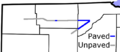
North Fork and South Fork of Wabash Cannonball Trail
-
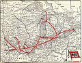
Wabash Railroad map, showing North and South Forks of the trail in Ohio


