
Sangamon County, Illinois facts for kids
Quick facts for kids
Sangamon County
|
|||
|---|---|---|---|

Sangamon County Courthouse in 2017
|
|||
|
|||

Location within the U.S. state of Illinois
|
|||
 Illinois's location within the U.S. |
|||
| Country | |||
| State | |||
| Founded | 1821 | ||
| Named for | Sangamon River | ||
| Seat | Springfield | ||
| Largest city | Springfield | ||
| Area | |||
| • Total | 877 sq mi (2,270 km2) | ||
| • Land | 868 sq mi (2,250 km2) | ||
| • Water | 8.7 sq mi (23 km2) 1.0% | ||
| Population
(2020)
|
|||
| • Total | 196,343 | ||
| • Density | 223.88/sq mi (86.44/km2) | ||
| Congressional districts | 13th, 15th | ||


Sangamon County is a place in the middle of Illinois, a state in the United States. It's like a big neighborhood with many towns and cities. In 2020, about 196,343 people lived here. The main city and county seat is Springfield, which is also the capital city of Illinois.
Sangamon County is part of the larger Springfield area. This means it's connected to nearby towns and cities for jobs and daily life.
Contents
History of Sangamon County

How Sangamon County Started
Sangamon County was created in 1821. It was formed from parts of Madison and Bond counties. The county got its name from the Sangamon River, which flows through it.
What Does "Sangamon" Mean?
The exact meaning of the name "Sangamon" is a bit of a mystery! One idea is that it comes from a word in the Pottawatomie language, Sain-guee-mon. This word might mean "where there is plenty to eat." Another idea is that French explorers named the river "St. Gamo" in the late 1600s. This was to honor an old French monk. The French way of saying "San-Gamo" might have become "Sangamon."
Abraham Lincoln's Connection to Sangamon County
Before he became President of the United States, Abraham Lincoln was a politician in Sangamon County. He worked in the Illinois Legislature, which is like the state's law-making group. Lincoln and other leaders helped make Springfield the capital of Illinois. Springfield is the main city in Sangamon County. Lincoln also represented this area when he was in the US House of Representatives.
Other important people from Sangamon County include Colonel Edmund Dick Taylor. He was known as "Father of the Greenback" because of his work with money. Also, the rich businessmen Jacob Bunn and John Whitfield Bunn lived and worked here. Their actions helped shape the history of Sangamon County.
Geography and Nature
Where is Sangamon County?
Sangamon County covers about 877 square miles. Most of this area, about 868 square miles, is land. The rest, about 8.7 square miles, is water.
Weather in Sangamon County
The weather in Sangamon County changes throughout the year. In Springfield, the county seat, January is usually the coldest month. Temperatures can be around 17°F. July is the warmest, with temperatures around 87°F. The county has seen very cold days, like -24°F in 1905. It has also had very hot days, like 112°F in 1954. Rain and snow also vary, with May usually being the wettest month.
Main Roads and Transportation
Many important roads run through Sangamon County. These include major highways like Interstate 55 and Interstate 72. These roads help people travel easily across the county and to other parts of Illinois.
 Interstate 55
 Interstate 55 Business Loop
 Interstate 72
 U.S. Route 36
 Illinois Route 4
 Illinois Route 29
 Illinois Route 54
 Illinois Route 97
 Illinois Route 104
 Illinois Route 124
 Illinois Route 123
 Illinois Route 125
The county also has public transportation. The Sangamon Mass Transit District helps people get around Springfield and nearby areas. There is also the Springfield train station and bus stops for longer trips.
Neighboring Counties
Sangamon County shares borders with several other counties:
- Menard County – to the north
- Logan County – to the northeast
- Macon County – to the east
- Christian County – to the southeast
- Montgomery County – to the south
- Macoupin County – to the south
- Morgan County – to the west
- Cass County – to the northwest
Protected Natural Areas
Sangamon County has special places that are protected for their history or nature. These include:
- Lincoln Home National Historic Site: This is where Abraham Lincoln lived before becoming president.
- Springfield 1908 Race Riot National Monument: This site remembers an important historical event.
- Sangchris Lake State Recreation Area: A state park for outdoor activities like fishing and boating.
People and Population
Who Lives in Sangamon County?
In 2010, there were about 197,465 people living in Sangamon County. Most people (83.6%) were white. About 11.8% were black or African American. Other groups included Asian people (1.6%) and American Indian people (0.2%). About 1.8% of the population was Hispanic or Latino.
Many people in Sangamon County have German (29.4%), Irish (14.8%), or English (12.1%) backgrounds. The average age in the county was about 39.2 years old.
Families and Homes
In 2010, there were about 82,986 homes in Sangamon County. About 30.4% of these homes had children under 18 living in them. Many homes (44.4%) were married couples living together. The average household had 2.33 people.
The median income for a family was about $66,917. This means half of the families earned more than this, and half earned less. About 13.4% of all people in the county lived below the poverty line. This included about 19.7% of children under 18.
Cities and Towns
Sangamon County has several cities, villages, and smaller communities.
Cities in Sangamon County
- Auburn
- Leland Grove
- Springfield (This is the main city and county seat.)
- Virden
Villages in Sangamon County
- Berlin
- Buffalo
- Cantrall
- Chatham
- Clear Lake
- Curran
- Dawson
- Divernon
- Grandview
- Illiopolis
- Jerome
- Loami
- Mechanicsburg
- New Berlin
- Pawnee
- Pleasant Plains
- Riverton
- Rochester
- Sherman
- Southern View
- Spaulding
- Thayer
- Williamsville
Smaller Communities (Unincorporated)
These are places that are not officially cities or villages, but people live there.
- Andrew
- Archer
- Barclay
- Barr
- Bates
- Berry
- Bissell
- Bradfordton
- Breckenridge
- Buckhart
- Buffalo Hart
- Cimic
- Clayville
- Farmingdale
- Glenarm
- Island Grove
- Lowder
- New City
- Riddle Hill
- Salisbury
- Toronto
- Zenobia
Townships in Sangamon County
Sangamon County is also divided into smaller areas called townships. These help manage local services.
- Auburn
- Ball
- Buffalo Hart
- Capital
- Cartwright
- Chatham
- Clear Lake
- Cooper
- Cotton Hill
- Curran
- Divernon
- Fancy Creek
- Gardner
- Illiopolis
- Island Grove
- Lanesville
- Loami
- Maxwell
- Mechanicsburg
- New Berlin
- Pawnee
- Rochester
- Springfield
- Talkington
- Williams
- Woodside
Education in Sangamon County
Many school districts serve the students of Sangamon County. These districts provide education from kindergarten through 12th grade. Some of these schools might have their main offices in other counties, but they still serve parts of Sangamon County.
- A-C Central Community Unit School District 262
- Community Unit School District 16
- Athens Community Unit School District 213
- Auburn Community Unit School District 10
- Ball-Chatham Community Unit School District 5
- Edinburg Community Unit School District 4
- Mount Pulaski Community Unit District 23
- North Mac Community Unit School District 34
- Pawnee Community Unit School District 11
- Porta Community Unit School District 202
- Pleasant Plains Community Unit School District 8
- Riverton Community Unit School District 14
- Rochester Community Unit School District 3A
- Sangamon Valley Community Unit School District 9
- Springfield School District 186
- Tri-City Community Unit School District 1
- Waverly Community Unit School District 6
- Williamsville Community Unit School District 15
Historical Sites and Forts
- Camp Butler: This is a historic site that was once a military camp.
Images for kids
-
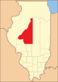
Sangamon County from the time of its creation to 1823
-
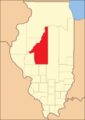
Sangamon County between 1823 and 1825
-
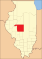
Sangamon County between 1825 and 1839
-
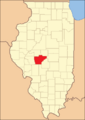
Sangamon in 1839, when the creation of Logan and Menard Counties reduced it to its present borders


See also
 In Spanish: Condado de Sangamon para niños
