Auburn, Illinois facts for kids
Quick facts for kids
Auburn
|
|
|---|---|
| Nickname(s):
The Redbud City
|
|

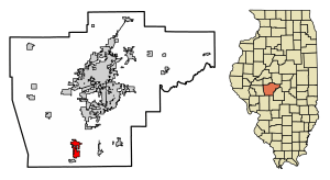
Location of Auburn in Sangamon County, Illinois.
|
|

Location of Illinois in the United States
|
|
| Country | United States |
| State | Illinois |
| County | Sangamon |
| Area | |
| • Total | 4.12 sq mi (10.68 km2) |
| • Land | 4.12 sq mi (10.68 km2) |
| • Water | 0.00 sq mi (0.00 km2) |
| Elevation | 610 ft (190 m) |
| Population
(2020)
|
|
| • Total | 4,574 |
| • Density | 1,109.12/sq mi (428.25/km2) |
| Time zone | UTC-6 (CST) |
| • Summer (DST) | UTC-5 (CDT) |
| ZIP Code(s) |
62615
|
| Area code(s) | 217 |
| FIPS code | 17-02921 |
| GNIS feature ID | 2394023 |
| Wikimedia Commons | Auburn, Illinois |
| Website | http://www.auburnillinois.us/ |
Auburn is a city located in Sangamon County, Illinois, United States. In 2020, about 4,574 people lived there. Auburn is part of the larger Springfield area. It's sometimes called "The Redbud City" because of the beautiful redbud trees.
Contents
History of Auburn
Auburn was first planned out in 1836. It was about a mile north of where it is today. Many towns named Auburn were planned in Illinois around this time. This period was known as the "town lot boom."
George and Asa Eastman bought a lot of land in the area. They were the ones who planned the town. Their sister, Hannah, named it after Auburn, Maine. This was near their family's old home.
Early Businesses and Survival
The Eastman family ran a tannery (where animal hides are made into leather) and a flour mill. The mill used steam power. They operated these businesses in Auburn until 1841. Then, they moved to Springfield.
After they left, Auburn only had about six households. Many towns started during this time failed. But Auburn survived because it was on a postal stagecoach line. This line ran between Alton and Springfield.
From 1839, Auburn became the place for the local post office. The stagecoach road followed what is now Illinois State Route 4. Even though it was small, Auburn had a tavern and shops. It was a meeting place for the people living in the countryside nearby.
Moving the Town
The Alton and Sangamon Railroad started running in 1852. Its route did not go through the original Auburn. So, in 1853, the town moved a mile south. This new spot was right on the railroad line.
By 1860, nearly 250 people lived in the relocated town. At first, it was called "Wineman." This name came from the local landowner who helped the railroad bypass the old Auburn. But when the state officially made it a town in 1865, it was renamed Auburn.
Coal Mining Era
From the 1880s until 1924, coal mining was very important to Auburn's economy. Most of the miners were new people who moved to the town. However, many local businesses were owned by families who had lived there for a long time.
First Rural Free Delivery
In 1896, the Auburn post office was part of a big test. It was the first place in Illinois to have Rural Free Delivery service. This meant mail was delivered directly to homes in the countryside. Three mail carriers rode routes that were 35 miles long.
The test was very successful. Some local farmers even changed their post office to Auburn to get this new service. The First Assistant Postmaster General noted that the roads were "almost as difficult of transit as when Abraham Lincoln 'rode the circuit'."
Town Square Fire
In 1910, a big fire destroyed much of Auburn's town square. This was a major event for the community.
Route 66 Connection
From 1926 to 1930, US Route 66 passed through Auburn. It followed a path similar to today's State Route 4. A part of the original Route 66 is still there just north of Auburn. It's called the "Auburn Brick Road."
This brick-paved road is special for its engineering. It is even listed in the National Register of Historic Places. The brick paving was not finished until 1931. By then, US 66 had already changed its route to the east.
Geography
According to the 2010 census, Auburn covers an area of about 4.08 square miles (10.6 square kilometers). All of this area is land.
Population Information
| Historical population | |||
|---|---|---|---|
| Census | Pop. | %± | |
| 1880 | 288 | — | |
| 1890 | 874 | 203.5% | |
| 1900 | 1,281 | 46.6% | |
| 1910 | 1,814 | 41.6% | |
| 1920 | 2,660 | 46.6% | |
| 1930 | 2,242 | −15.7% | |
| 1940 | 1,952 | −12.9% | |
| 1950 | 1,963 | 0.6% | |
| 1960 | 2,209 | 12.5% | |
| 1970 | 2,594 | 17.4% | |
| 1980 | 3,616 | 39.4% | |
| 1990 | 3,724 | 3.0% | |
| 2000 | 4,317 | 15.9% | |
| 2010 | 4,771 | 10.5% | |
| 2020 | 4,574 | −4.1% | |
| U.S. Decennial Census | |||
In 2000, there were 4,317 people living in Auburn. These people lived in 1,618 households. About 1,187 of these were families. The population density was about 1,368 people per square mile.
Many households (42%) had children under 18 living with them. More than half (56.6%) were married couples. About 22.9% of households were single people living alone.
The average age in Auburn was 33 years old. About 30.4% of the people were under 18. About 11.5% were 65 or older.
Notable People
- Dutch Leonard was born in Auburn. He was a MLB pitcher for 20 years.
- Roswell Magill (1895–1963) was born in Auburn. He was a leading expert on taxes in the 1930s.
See Also
 In Spanish: Auburn (Illinois) para niños
 | Precious Adams |
 | Lauren Anderson |
 | Janet Collins |


