
Morgan County, Illinois facts for kids
Quick facts for kids
Morgan County
|
|
|---|---|

Morgan County Courthouse, Jacksonville
|
|

Location within the U.S. state of Illinois
|
|
 Illinois's location within the U.S. |
|
| Country | |
| State | |
| Founded | 1823 |
| Named for | Daniel Morgan |
| Seat | Jacksonville |
| Largest city | Jacksonville |
| Area | |
| • Total | 572 sq mi (1,480 km2) |
| • Land | 569 sq mi (1,470 km2) |
| • Water | 3.5 sq mi (9 km2) 0.6% |
| Population
(2020)
|
|
| • Total | 32,915 |
| • Density | 57.54/sq mi (22.218/km2) |
| Time zone | UTC−6 (Central) |
| • Summer (DST) | UTC−5 (CDT) |
| Congressional district | 15th |
Morgan County is a county in the state of Illinois. In 2020, about 32,915 people lived here. The main city and government center is Jacksonville.
Morgan County is part of a larger area called the Jacksonville Micropolitan Statistical Area. This area is also linked to the bigger Springfield–Jacksonville–Lincoln Combined Statistical Area.
Contents
History of Morgan County
Morgan County was created in 1823. It was formed from parts of Greene and Sangamon Counties. The county was named after General Daniel Morgan. He was a hero who won an important battle against the British in the American Revolutionary War. This battle was called the Battle of Cowpens.
The city of Jacksonville was started in 1825. It was founded by settlers from New England. These settlers were often called "Yankees." They were descendants of English Puritans who came to New England in the 1600s. They moved west into the Northwest Territory in the early 1800s. Many came after the Erie Canal was finished and the Black Hawk War ended.
New England was becoming crowded. Families were large, and there wasn't enough land for everyone to farm. So, many Yankee families moved to the Midwest. When they arrived in the area that is now Jacksonville, it was mostly thick forests and wild prairies. The New Englanders built farms and roads. They also set up government buildings and mail routes.
These settlers brought their New England values with them. They strongly believed in education and built many schools. They also supported ending slavery, which was called abolitionism. Most of them belonged to the Congregationalist Church. Some had become Methodists, Presbyterians, or Baptists before moving. Jacksonville kept many of these New England traditions for a long time.
-
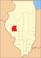
Morgan County from 1823 to 1837
-
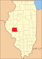
Morgan County between 1837 and 1839, before Scott County was formed
-
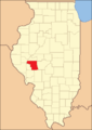
Morgan County between 1839 and 1845
-
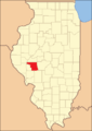
Morgan County in 1845, showing its current borders


Geography and Nature
Morgan County covers about 572 square miles. Most of this area, 569 square miles, is land. The rest, about 3.5 square miles, is water.
The 90th Meridian of Longitude passes through Morgan County. You can even see a road sign for it on I-72!
Climate and Weather
| Weather chart for Jacksonville, Illinois | |||||||||||||||||||||||||||||||||||||||||||||||
|---|---|---|---|---|---|---|---|---|---|---|---|---|---|---|---|---|---|---|---|---|---|---|---|---|---|---|---|---|---|---|---|---|---|---|---|---|---|---|---|---|---|---|---|---|---|---|---|
| J | F | M | A | M | J | J | A | S | O | N | D | ||||||||||||||||||||||||||||||||||||
|
1.4
34
15
|
1.7
40
19
|
3.2
52
29
|
3.8
64
39
|
4.9
74
49
|
4.4
83
59
|
3.9
87
63
|
3.4
85
60
|
3.5
79
52
|
2.6
68
41
|
3.5
52
31
|
2.5
39
20
|
||||||||||||||||||||||||||||||||||||
| temperatures in °F precipitation totals in inches source: The Weather Channel |
|||||||||||||||||||||||||||||||||||||||||||||||
|
Metric conversion
|
|||||||||||||||||||||||||||||||||||||||||||||||
The weather in Jacksonville changes throughout the year. In January, the average low temperature is about 15 degrees Fahrenheit. In July, the average high temperature is about 87 degrees Fahrenheit. The coldest temperature ever recorded was -28 degrees Fahrenheit in February 1934. The hottest was 114 degrees Fahrenheit in July 1954.
The amount of rain and snow also changes. January usually gets about 1.35 inches of precipitation. May is the wettest month, with about 4.86 inches.
Main Roads
 Interstate 72
 U.S. Route 36
 U.S. Route 67
 Illinois Route 78
 Illinois Route 100
 Illinois Route 104
 Illinois Route 111
 Illinois Route 267
Neighboring Counties
- Cass County – to the north
- Sangamon County – to the east
- Macoupin County – to the southeast
- Greene County – to the south
- Pike County – to the west
- Scott County – to the southwest
- Brown County – to the northwest
Protected Areas
Part of the Meredosia National Wildlife Refuge is located in Morgan County. This is a special place that protects wildlife.
People of Morgan County
| Historical population | |||
|---|---|---|---|
| Census | Pop. | %± | |
| 1830 | 12,714 | — | |
| 1840 | 19,547 | 53.7% | |
| 1850 | 16,064 | −17.8% | |
| 1860 | 22,112 | 37.6% | |
| 1870 | 28,463 | 28.7% | |
| 1880 | 31,514 | 10.7% | |
| 1890 | 32,636 | 3.6% | |
| 1900 | 35,006 | 7.3% | |
| 1910 | 34,420 | −1.7% | |
| 1920 | 33,567 | −2.5% | |
| 1930 | 34,240 | 2.0% | |
| 1940 | 36,378 | 6.2% | |
| 1950 | 35,568 | −2.2% | |
| 1960 | 36,571 | 2.8% | |
| 1970 | 36,174 | −1.1% | |
| 1980 | 37,502 | 3.7% | |
| 1990 | 36,397 | −2.9% | |
| 2000 | 36,616 | 0.6% | |
| 2010 | 35,547 | −2.9% | |
| 2020 | 32,915 | −7.4% | |
| 2023 (est.) | 32,140 | −9.6% | |
| US Decennial Census 1790-1960 1900-1990 1990-2000 2010 |
|||
In 2010, there were about 35,547 people living in Morgan County. There were 14,104 households, which are groups of people living together. The population density was about 62.5 people per square mile. This means that for every square mile of land, there were about 62.5 people.
Most people in the county were white (90.9%). About 6.0% were Black or African American. Other groups made up smaller percentages. About 2.0% of the population was of Hispanic or Latino background.
Many people in Morgan County have German (25.9%), American (21.6%), Irish (15.4%), or English (14.5%) roots. Many who say they have "American" ancestry actually have English roots. Their families have been in North America for a very long time, often since the 1600s.
About 28.3% of households had children under 18 living with them. The average household had 2.30 people. The average age of people in the county was 40.8 years old.
Cities and Towns
Cities
- Jacksonville (This is the county seat)
- Waverly
Villages
Unincorporated Communities
These are smaller communities that are not officially cities or villages.
Education
Morgan County has many schools and school districts. Here are some of them:
- A-C Central Community Unit School District 262
- Community Unit School District 16
- Franklin Community Unit School District 1
- Greenfield Community Unit School District 10
- Jacksonville School District 117
- Meredosia-Chambersburg Community Unit School District 11
- Pleasant Plains Community Unit School District 8
- Scott-Morgan Consolidated Unit School District 2
- Triopia Community Unit School District 27
- Virginia Community Unit School District 64
- Waverly Community Unit School District 6
- Winchester Community Unit School District 1
There are also special state-run schools in Morgan County:
- Illinois School for the Deaf (for students who are deaf or hard of hearing)
- Illinois School for the Visually Impaired (for students who are blind or have low vision)
Private Schools
- Routt Catholic High School
Colleges and Universities
- Illinois College
- Lincoln Land Community College Jacksonville Outreach Center
- MacMurray College (This college is now closed)
See also
 In Spanish: Condado de Morgan (Illinois) para niños
