
Pike County, Illinois facts for kids
Quick facts for kids
Pike County
|
|
|---|---|
|
County
|
|

Pike County Courthouse, Pittsfield
|
|

Location within the U.S. state of Illinois
|
|
 Illinois's location within the U.S. |
|
| Country | |
| State | |
| Founded | January 31, 1821 |
| Named for | Zebulon Pike |
| Seat | Pittsfield |
| Largest city | Pittsfield |
| Area | |
| • Total | 849 sq mi (2,200 km2) |
| • Land | 831 sq mi (2,150 km2) |
| • Water | 18 sq mi (50 km2) 2.1% |
| Population
(2020)
|
|
| • Total | 14,739 |
| • Density | 17.360/sq mi (6.703/km2) |
| Time zone | UTC−6 (Central) |
| • Summer (DST) | UTC−5 (CDT) |
| Congressional district | 15th |
Pike County is a county in the U.S. state of Illinois. It is located in western Illinois, between the Mississippi River and the Illinois River. In 2020, about 14,739 people lived here. The main town and county seat is Pittsfield.
Contents
The History of Pike County
How Pike County Was Formed
Pike County was created in January 1821. It was formed from parts of Edwards and Madison Counties. The county was named after Zebulon Pike. He was an explorer who led an expedition in 1806. His job was to map the southern and western parts of the Louisiana Purchase. Pike also fought in the War of 1812 and died in 1813.
Before European settlers arrived, French traders and hunters traveled through the area. Pike County was much larger at first. It stretched from the Illinois and Mississippi rivers all the way north to the Wisconsin border. The first county seat was Cole's Grove. In 1822, Chicago was even described as a small village within Pike County.
New Philadelphia: A Special Town
The New Philadelphia Town Site is a very important historical place. It was listed on the National Register of Historic Places in 2005. Later, it became a National Historic Landmark in 2009. In 2022, it was made a National Park.
This town was founded by Frank McWorter. He was an early free Black settler in Pike County. New Philadelphia was the first town in the United States founded by a Black man. McWorter bought land for the town without even seeing it. He used money from selling land to buy freedom for his family members who were enslaved.
In 1836, he founded the town of New Philadelphia near Barry. He was elected mayor and lived there his whole life. The town grew, but later, a railroad was built that bypassed it. This made the town's growth slow down. Eventually, it was abandoned in the 20th century. Today, the town site is an archaeological site.
Pike County Today
In recent years, Pike County has become well-known for whitetail deer hunting. It is especially popular for bowhunting.
Geography of Pike County
Land and Water
Pike County covers a total area of about 849 square miles (2,199 square kilometers). Most of this area, about 831 square miles (2,152 square kilometers), is land. The remaining 18 square miles (47 square kilometers) are water.
The county is located on high ground between two major rivers. The Illinois River forms its eastern border. The Mississippi River borders Missouri to the west.
Major Roads
Pike County has two important interstate highways. I-72 crosses both the Illinois and Mississippi rivers to enter the county. I-172 also extends into the county.
 Interstate 72
 Interstate 172
 U.S. Route 36
 U.S. Route 54
 Illinois Route 57
 Illinois Route 96
 Illinois Route 99
 Illinois Route 100
 Illinois Route 104
 Illinois Route 106
 Illinois Route 107
Neighboring Counties
Pike County borders many other counties. It is one of the few counties in the U.S. that touches as many as nine other counties.
- Adams County – north
- Brown County – northeast
- Scott County – east
- Morgan County – east
- Greene County – southeast
- Calhoun County – south
- Pike County, Missouri – southwest
- Ralls County, Missouri – west
- Marion County, Missouri – northwest
Protected Areas
Part of the Great River National Wildlife Refuge is located in Pike County. This area helps protect wildlife and their habitats.
People of Pike County (Demographics)
| Historical population | |||
|---|---|---|---|
| Census | Pop. | %± | |
| 1830 | 2,396 | — | |
| 1840 | 11,728 | 389.5% | |
| 1850 | 18,819 | 60.5% | |
| 1860 | 27,249 | 44.8% | |
| 1870 | 30,768 | 12.9% | |
| 1880 | 33,751 | 9.7% | |
| 1890 | 31,000 | −8.2% | |
| 1900 | 31,595 | 1.9% | |
| 1910 | 28,622 | −9.4% | |
| 1920 | 26,866 | −6.1% | |
| 1930 | 24,357 | −9.3% | |
| 1940 | 25,340 | 4.0% | |
| 1950 | 22,155 | −12.6% | |
| 1960 | 20,552 | −7.2% | |
| 1970 | 19,185 | −6.7% | |
| 1980 | 18,896 | −1.5% | |
| 1990 | 17,577 | −7.0% | |
| 2000 | 17,384 | −1.1% | |
| 2010 | 16,430 | −5.5% | |
| 2020 | 14,739 | −10.3% | |
| 2023 (est.) | 14,342 | −12.7% | |
| US Decennial Census 1790-1960 1900-1990 1990-2000 2010 |
|||
In 2010, there were 16,430 people living in Pike County. The population density was about 19.8 people per square mile. Most residents, about 96.9%, were white. About 1.7% were Black or African American. Small percentages were Asian, American Indian, or from other races. About 1.0% of the population was of Hispanic or Latino origin.
Many people in Pike County have German (26.3%), American (16.8%), English (15.1%), or Irish (13.4%) backgrounds. The average age of people living in Pike County was 42.5 years old.
Towns and Villages
Settlements
| Settlement | Population | Type | Townships |
|---|---|---|---|
| Barry | 1,318 | City | Barry |
| Baylis | 200 | Village | New Salem |
| Detroit | 83 | Village | Detroit |
| El Dara | 78 | Village | Derry |
| Florence | 17 | Village | Detroit |
| Griggsville | 1,226 | City | Griggsville |
| Hull | 461 | Village | Kinderhook |
| Kinderhook | 216 | Village | Barry, Kinderhook |
| Milton | 271 | Village | Montezuma |
| Nebo | 340 | Village | Spring Creek |
| New Canton | 359 | Town | Pleasant Vale |
| New Salem | 136 | Village | New Salem |
| Pearl | 138 | Village | Pearl |
| Perry | 397 | Village | Perry |
| Pittsfield† | 4,576 | City | Newburg, Pittsfield |
| Pleasant Hill | 966 | Village | Pleasant Hill |
| Rockport | 67 | CDP | Atlas |
| Time | 29 | Village | Hardin |
| Valley City | 13 | Village | Flint |
† – County seat
Townships
| Township | Population | Housing Units | Total Area | Land Area | Water Area |
|---|---|---|---|---|---|
| Atlas | 563 | 321 | 67.88 sq mi (175.8 km2) | 63.71 sq mi (165.0 km2) | 4.17 sq mi (10.8 km2) |
| Barry | 1,675 | 791 | 38.51 sq mi (99.7 km2) | 38.50 sq mi (99.7 km2) | 0.01 sq mi (0.026 km2) |
| Chambersburg | 241 | 89 | 29.63 sq mi (76.7 km2) | 29.09 sq mi (75.3 km2) | 0.54 sq mi (1.4 km2) |
| Cincinnati | 31 | 54 | 26.73 sq mi (69.2 km2) | 23.82 sq mi (61.7 km2) | 2.91 sq mi (7.5 km2) |
| Derry | 247 | 115 | 37.40 sq mi (96.9 km2) | 37.40 sq mi (96.9 km2) | 0.00 sq mi (0 km2) |
| Detroit | 312 | 163 | 26.98 sq mi (69.9 km2) | 26.24 sq mi (68.0 km2) | 0.74 sq mi (1.9 km2) |
| Fairmount | 188 | 109 | 37.62 sq mi (97.4 km2) | 37.62 sq mi (97.4 km2) | 0.00 sq mi (0 km2) |
| Flint | 96 | 47 | 16.17 sq mi (41.9 km2) | 15.31 sq mi (39.7 km2) | 0.86 sq mi (2.2 km2) |
| Griggsville | 1,430 | 671 | 37.64 sq mi (97.5 km2) | 37.64 sq mi (97.5 km2) | 0.00 sq mi (0 km2) |
| Hadley | 262 | 130 | 36.86 sq mi (95.5 km2) | 36.84 sq mi (95.4 km2) | 0.02 sq mi (0.052 km2) |
| Hardin | 212 | 105 | 37.41 sq mi (96.9 km2) | 37.39 sq mi (96.8 km2) | 0.02 sq mi (0.052 km2) |
| Kinderhook | 840 | 422 | 37.91 sq mi (98.2 km2) | 37.86 sq mi (98.1 km2) | 0.05 sq mi (0.13 km2) |
| Levee | 47 | 39 | 25.03 sq mi (64.8 km2) | 22.02 sq mi (57.0 km2) | 3.01 sq mi (7.8 km2) |
| Martinsburg | 419 | 186 | 37.74 sq mi (97.7 km2) | 37.74 sq mi (97.7 km2) | 0.00 sq mi (0 km2) |
| Montezuma | 540 | 254 | 34.45 sq mi (89.2 km2) | 33.75 sq mi (87.4 km2) | 0.70 sq mi (1.8 km2) |
| Newburg | 949 | 428 | 37.55 sq mi (97.3 km2) | 37.21 sq mi (96.4 km2) | 0.35 sq mi (0.91 km2) |
| New Salem | 573 | 276 | 38.21 sq mi (99.0 km2) | 38.21 sq mi (99.0 km2) | 0.00 sq mi (0 km2) |
| Pearl | 282 | 193 | 25.26 sq mi (65.4 km2) | 24.63 sq mi (63.8 km2) | 0.63 sq mi (1.6 km2) |
| Perry | 594 | 310 | 37.22 sq mi (96.4 km2) | 37.21 sq mi (96.4 km2) | 0.01 sq mi (0.026 km2) |
| Pittsfield | 4,477 | 1,982 | 37.86 sq mi (98.1 km2) | 37.81 sq mi (97.9 km2) | 0.06 sq mi (0.16 km2) |
| Pleasant Hill | 1,259 | 631 | 37.60 sq mi (97.4 km2) | 37.56 sq mi (97.3 km2) | 0.04 sq mi (0.10 km2) |
| Pleasant Vale | 563 | 321 | 67.88 sq mi (175.8 km2) | 63.71 sq mi (165.0 km2) | 4.17 sq mi (10.8 km2) |
| Ross | 573 | 286 | 38.98 sq mi (101.0 km2) | 38.97 sq mi (100.9 km2) | 0.01 sq mi (0.026 km2) |
| Spring Creek | 591 | 295 | 37.41 sq mi (96.9 km2) | 37.40 sq mi (96.9 km2) | 0.01 sq mi (0.026 km2) |
- Atlas Township
- Barry Township
- Chambersburg Township
- Cincinnati Township
- Derry Township
- Detroit Township
- Fairmount Township
- Flint Township
- Griggsville Township
- Hadley Township
- Hardin Township
- Kinderhook Township
- Levee Township
- Martinsburg Township
- Montezuma Township
- Newburg Township
- New Salem Township
- Pearl Township
- Perry Township
- Pittsfield Township
- Pleasant Hill Township
- Pleasant Vale Township
- Ross Township
- Spring Creek Township
Unincorporated Communities
These are smaller communities that are not officially organized as cities or villages.
- Atlas
- Bedford
- Chambersburg
- East Hannibal
- Fishhook
- Maysville
- Munger
- New Hartford
- Pike Station
- Seehorn
- Straut
- Summer Hill
Ghost Towns
These are towns that no longer exist or are completely abandoned.
Images for kids
-
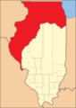
Pike County from the time it was created until 1823
-
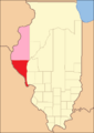
Pike County between 1823 and 1825, including extra territory
-
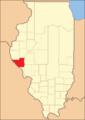
Pike County in 1825, showing its current borders


See also
 In Spanish: Condado de Pike (Illinois) para niños
