Marion County, Missouri facts for kids
Quick facts for kids
Marion County
|
|
|---|---|

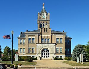
Marion County courthouse in Palmyra
|
|

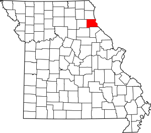
Location within the U.S. state of Missouri
|
|
 Missouri's location within the U.S. |
|
| Country | |
| State | |
| Founded | December 23, 1826 |
| Named for | Francis Marion |
| Seat | Palmyra |
| Largest city | Hannibal |
| Area | |
| • Total | 444 sq mi (1,150 km2) |
| • Land | 437 sq mi (1,130 km2) |
| • Water | 7.4 sq mi (19 km2) 1.7% |
| Population
(2020)
|
|
| • Total | 28,525 |
| • Density | 64/sq mi (25/km2) |
| Time zone | UTC−6 (Central) |
| • Summer (DST) | UTC−5 (CDT) |
| Congressional district | 6th |
| Website | http://marioncountymo.com/ |
Marion County is a county in the northeastern part of Missouri. In 2020, about 28,525 people lived here. The main town where the county government is located is Palmyra.
What's special about Marion County is that it has two courthouses. One is in Palmyra, and the other is in Hannibal. The county was officially started on December 23, 1826. It was named after General Francis Marion. He was a hero from the American Revolutionary War, known as the "Swamp Fox." Before it became a county, this area was called the "Two Rivers Country."
Contents
Geography of Marion County
Marion County covers a total area of about 444 square miles. Most of this is land, around 437 square miles. The rest, about 7.4 square miles, is water.
Neighboring Counties
Marion County shares borders with several other counties:
- Lewis County (to the north)
- Adams County, Illinois (to the northeast)
- Pike County, Illinois (to the southeast)
- Ralls County (to the south)
- Monroe County (to the southwest)
- Shelby County (to the west)
Main Roads
Many important roads pass through Marion County:
 I-72
I-72 US-24
US-24 US-36
US-36 US-61
US-61 Route 6
 Route 79
 Route 168
 Great River Road
Public Transportation
You can find these transportation options in the county:
- Burlington Trailways (bus service)
- OATS Transit (local bus service)
- Amtrak Illinois Zephyr and Carl Sandburg (train service, proposed)
Railroads
Trains are also important for moving goods through the county:
- BNSF Railway
- Norfolk Southern Railway
History of Marion County
Marion County was formed in 1845. It was created from parts of Ralls and Shelby Counties. Early settlers came from Virginia and Kentucky. They were mostly farmers looking for good land.
The county is named after General Francis Marion. He was a famous leader during the American Revolutionary War. The county seat, Palmyra, was started in 1833. It became an important port town on the Mississippi River.
By the late 1800s, farming was very important in Marion County. Tobacco was the main crop grown here. Farmers also grew cotton, wheat, barley, oats, and hay. They raised animals like horses, mules, and cattle.
The most famous person from Marion County is Mark Twain. His real name was Samuel Langhorne Clemens. He was born in 1835 in the village of Florida. His childhood experiences in Hannibal inspired his famous books. These include the adventures of Tom Sawyer and Huckleberry Finn.
During the American Civil War, the region was divided. However, those who supported the Union won out. Today, Marion County is still mainly a farming area. It has many historic places and buildings. Tourism is also a big industry, especially around Mark Twain's stories and settings.
Population of Marion County
| Historical population | |||
|---|---|---|---|
| Census | Pop. | %± | |
| 1830 | 4,837 | — | |
| 1840 | 9,623 | 98.9% | |
| 1850 | 12,230 | 27.1% | |
| 1860 | 18,838 | 54.0% | |
| 1870 | 23,780 | 26.2% | |
| 1880 | 24,837 | 4.4% | |
| 1890 | 26,233 | 5.6% | |
| 1900 | 26,331 | 0.4% | |
| 1910 | 30,572 | 16.1% | |
| 1920 | 30,226 | −1.1% | |
| 1930 | 33,493 | 10.8% | |
| 1940 | 31,576 | −5.7% | |
| 1950 | 29,765 | −5.7% | |
| 1960 | 29,522 | −0.8% | |
| 1970 | 28,121 | −4.7% | |
| 1980 | 28,638 | 1.8% | |
| 1990 | 27,682 | −3.3% | |
| 2000 | 28,289 | 2.2% | |
| 2010 | 28,781 | 1.7% | |
| 2020 | 28,525 | −0.9% | |
| U.S. Decennial Census 1790-1960 1900-1990 1990-2000 2010 |
|||
In 2010, there were 28,781 people living in Marion County. The population density was about 65 people per square mile. Most people in the county are White (93.26%). About 4.62% are Black or African American.
The average age in the county in 2010 was 37 years old. About 25.70% of the population was under 18.
2020 Census Information
| Race | Number of People | Percentage |
|---|---|---|
| White (not Hispanic) | 24,930 | 87.4% |
| Black or African American (not Hispanic) | 1,363 | 4.8% |
| Native American (not Hispanic) | 67 | 0.23% |
| Asian (not Hispanic) | 165 | 0.58% |
| Pacific Islander (not Hispanic) | 16 | 0.05% |
| Other/Mixed (not Hispanic) | 1,468 | 5.1% |
| Hispanic or Latino | 516 | 1.8% |
Education in Marion County
Marion County has several schools for students of all ages.
Public Schools
- Hannibal Public School District No. 60 in Hannibal
- Veterans Elementary School (Kindergarten to 5th grade)
- A.D. Stowell Elementary School (Kindergarten to 5th grade)
- Mark Twain Elementary School (Kindergarten to 5th grade)
- Oakwood Elementary School (Kindergarten to 5th grade)
- Eugene Field Elementary School (Kindergarten to 5th grade)
- Early Childhood Center (Preschool)
- Hannibal Middle School (6th to 8th grade)
- Hannibal High School (9th to 12th grade)
- Palmyra R-I School District in Palmyra
- Palmyra Elementary School (Kindergarten to 4th grade)
- Palmyra Middle School (5th to 8th grade)
- Palmyra High School (9th to 12th grade)
- Marion County R-II School District in Philadelphia
- Marion County Elementary School (Kindergarten to 6th grade)
- Marion County High School (7th to 12th grade)
Private Schools
- Holy Family Catholic School in Hannibal (Kindergarten to 9th grade)
- St. John’s Lutheran School in Hannibal (Kindergarten to 6th grade)
- Mission Hill Christian Academy in Palmyra, Missouri (Kindergarten to 12th grade)
Colleges and Universities
- Hannibal–LaGrange University in Hannibal is a private, four-year university.
Public Libraries
- Hannibal Free Public Library
- Palmyra Bicentennial Public Library
Communities in Marion County
Marion County has several cities, towns, and smaller communities.
Cities and Towns
- Hannibal
- Monroe City (mostly in Monroe County and a small part in Ralls County)
- Palmyra (the county seat)
Smaller Communities
- Barkley
- Bellville
- Benbow
- Cave City
- Ely
- Emerson
- Heather
- Helton
- Hester
- Little Union
- Mungers
- Naomi
- Nelsonville
- Newmarket
- North River
- Philadelphia
- Sharpsburg
- Smileyville
- Taylor
- Uva
- Warren
- West Ely
- West Quincy
- White Bear
- Withers Mill
- Woodland
Past Communities
Some communities that once existed in Marion County are:
Images for kids
See also
 In Spanish: Condado de Marion (Misuri) para niños
 | Toni Morrison |
 | Barack Obama |
 | Martin Luther King Jr. |
 | Ralph Bunche |


