Lewis County, Missouri facts for kids
Quick facts for kids
Lewis County
|
|
|---|---|

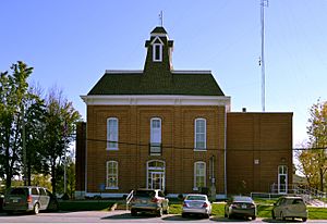
Lewis County Courthouse in Monticello
|
|

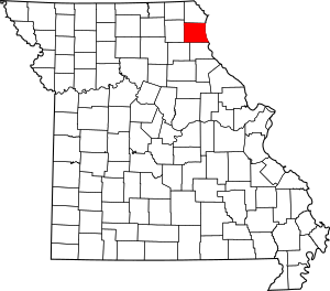
Location within the U.S. state of Missouri
|
|
 Missouri's location within the U.S. |
|
| Country | |
| State | |
| Founded | January 2, 1833 |
| Named for | Meriwether Lewis |
| Seat | Monticello |
| Largest city | Canton |
| Area | |
| • Total | 511 sq mi (1,320 km2) |
| • Land | 505 sq mi (1,310 km2) |
| • Water | 5.8 sq mi (15 km2) 1.1% |
| Population
(2020)
|
|
| • Total | 10,032 |
| • Density | 19.632/sq mi (7.580/km2) |
| Time zone | UTC−6 (Central) |
| • Summer (DST) | UTC−5 (CDT) |
| Congressional district | 6th |
Lewis County is a place in the northeastern part of Missouri, a state in the United States. It's called a county. In 2020, about 10,032 people lived there. The main town, or county seat, is Monticello. Lewis County was started on January 2, 1833. It was named after Meriwether Lewis, a famous explorer who was part of the Lewis and Clark Expedition. He also used to be the Governor of the Louisiana Territory.
Lewis County is also part of the larger Quincy, Illinois–Missouri area.
Contents
Geography of Lewis County
Lewis County covers a total area of about 511 square miles. Most of this is land (505 square miles), and a small part (about 5.8 square miles) is water.
Neighboring Counties
Lewis County shares borders with several other counties:
- Clark County (to the north)
- Hancock County, Illinois (to the northeast)
- Adams County, Illinois (to the southeast)
- Marion County (to the south)
- Shelby County (to the southwest)
- Knox County (to the west)
Main Roads
These are the most important roads that go through Lewis County:
Public Transportation
You can find these public transport options in the county:
- Burlington Trailways (bus service)
- OATS Transit (local transportation)
Railroads
- BNSF Railway (train tracks)
History of Lewis County
Lewis County was created in 1833. It was named after Meriwether Lewis, who explored the western United States with William Clark. The county is located in northeastern Missouri, right across the Mississippi River from Illinois.
Early settlers, mostly farmers from Virginia and Kentucky, moved to Lewis County. They liked the rich soil and easy river travel. The economy back then was based on farming, cutting down trees for wood, and mining for lead. The town of Canton also helped supply riverboats on the Mississippi River.
During the American Civil War, people in Lewis County had strong feelings for both the Union (the North) and the Confederacy (the South). There was some fighting, but the Union supporters eventually won control.
After the Civil War, slavery ended. The county's economy changed to focus on selling farm products like corn and wheat. Timber was also important. These goods were sent out from Canton, which was a busy port on the Mississippi River. Later, many young people from farms moved to the small towns in the county. The famous writer Mark Twain lived in the county for a short time. The beautiful river area inspired some of his writing.
Today, Lewis County is mostly rural, meaning it has a lot of countryside and farms. There are a few small towns, with Canton being the largest. The economy still relies on farming, especially soybeans and corn, and timber. Education is also important, as Canton is home to Culver–Stockton College. There are 12 historic places in the county listed on the National Register of Historic Places.
Population of Lewis County
| Historical population | |||
|---|---|---|---|
| Census | Pop. | %± | |
| 1840 | 6,040 | — | |
| 1850 | 6,578 | 8.9% | |
| 1860 | 12,286 | 86.8% | |
| 1870 | 15,114 | 23.0% | |
| 1880 | 15,925 | 5.4% | |
| 1890 | 15,935 | 0.1% | |
| 1900 | 16,724 | 5.0% | |
| 1910 | 15,514 | −7.2% | |
| 1920 | 13,465 | −13.2% | |
| 1930 | 12,093 | −10.2% | |
| 1940 | 11,490 | −5.0% | |
| 1950 | 10,733 | −6.6% | |
| 1960 | 10,984 | 2.3% | |
| 1970 | 10,993 | 0.1% | |
| 1980 | 10,901 | −0.8% | |
| 1990 | 10,233 | −6.1% | |
| 2000 | 10,494 | 2.6% | |
| 2010 | 10,211 | −2.7% | |
| 2020 | 10,032 | −1.8% | |
| U.S. Decennial Census 1790-1960 1900-1990 1990-2000 2010-2015 |
|||
In 2010, there were 10,211 people living in Lewis County. The county had about 21 people per square mile. Most people (about 96%) were White. About 2.5% were Black or African American. A small number of people were Native American, Asian, or from other backgrounds. About 0.7% of the population was Hispanic or Latino.
The average age of people in the county was 36 years old. About 25% of the population was under 18 years old.
2020 Census Information
| Race | Number of People | Percentage |
|---|---|---|
| White (not Hispanic) | 9,315 | 92.9% |
| Black or African American (not Hispanic) | 185 | 1.84% |
| Native American (not Hispanic) | 30 | 0.3% |
| Asian (not Hispanic) | 22 | 0.22% |
| Pacific Islander (not Hispanic) | 0 | 0% |
| Other/Mixed (not Hispanic) | 315 | 3.14% |
| Hispanic or Latino | 165 | 1.64% |
Education in Lewis County
Lewis County has several schools and libraries.
Public Schools
- Canton R-V School District in Canton
- Canton Elementary School (for grades K-6)
- Canton High School (for grades 7-12)
- Lewis County C-1 School District in Ewing
- Highland Elementary School (for grades K-6)
- Highland Junior-Senior High School (for grades 7-12)
Private Schools
- Cedar Falls School in Canton (for grades K-12) – This is a non-religious school.
Colleges and Universities
- Culver-Stockton College in Canton – This is a private, four-year college.
Public Libraries
- Canton Public Library
- Labelle Branch Library
- Lagrange Branch Library
Communities in Lewis County
Cities and Towns
- Canton
- Ewing
- La Belle
- La Grange
- Lewistown
- Monticello (This is the county seat, where the main county government offices are.)
Smaller Communities
These are smaller places in Lewis County that are not officially cities or towns:
See also
 In Spanish: Condado de Lewis (Misuri) para niños
 | Victor J. Glover |
 | Yvonne Cagle |
 | Jeanette Epps |
 | Bernard A. Harris Jr. |


