La Belle, Missouri facts for kids
Quick facts for kids
La Belle, Missouri
|
|
|---|---|

Location of La Belle, Missouri
|
|
| Country | United States |
| State | Missouri |
| County | Lewis |
| Area | |
| • Total | 0.68 sq mi (1.77 km2) |
| • Land | 0.68 sq mi (1.76 km2) |
| • Water | 0.00 sq mi (0.01 km2) |
| Elevation | 738 ft (225 m) |
| Population
(2020)
|
|
| • Total | 664 |
| • Density | 976.47/sq mi (377.18/km2) |
| Time zone | UTC-6 (Central (CST)) |
| • Summer (DST) | UTC-5 (CDT) |
| ZIP code |
63447
|
| Area code(s) | 660 |
| FIPS code | 29-39512 |
| GNIS feature ID | 2395561 |
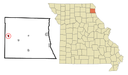
La Belle is a small city in western Lewis County, Missouri, in the United States. In 2020, about 664 people lived there. It is part of the Quincy, Illinois–Missouri area.
Contents
History of La Belle
The name "La Belle" comes from a French phrase meaning "the beautiful." This name was chosen because of the pretty scenery around the area. A post office opened in La Belle in 1856. The first people settled here permanently in 1857. The town's layout was officially planned in 1871. La Belle became an official city in 1872. Before that, it was a village and a stop for stage coaches.
Geography of La Belle
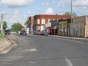
La Belle is located in Missouri at specific coordinates: 40.115624 degrees North and -91.915919 degrees West. The city covers a total area of about 0.68 square miles (1.76 square kilometers). All of this area is land. Missouri Route 6 goes through La Belle. This road is also known as State Street in many parts of the city.
Population in La Belle
| Historical population | |||
|---|---|---|---|
| Census | Pop. | %± | |
| 1880 | 341 | — | |
| 1890 | 702 | 105.9% | |
| 1900 | 966 | 37.6% | |
| 1910 | 1,017 | 5.3% | |
| 1920 | 878 | −13.7% | |
| 1930 | 820 | −6.6% | |
| 1940 | 833 | 1.6% | |
| 1950 | 840 | 0.8% | |
| 1960 | 866 | 3.1% | |
| 1970 | 848 | −2.1% | |
| 1980 | 845 | −0.4% | |
| 1990 | 655 | −22.5% | |
| 2000 | 669 | 2.1% | |
| 2010 | 660 | −1.3% | |
| 2020 | 664 | 0.6% | |
| U.S. Decennial Census | |||
What the 2010 Census Showed
In 2010, the census counted 660 people living in La Belle. There were 277 households, which are groups of people living together. The city had about 970 people per square mile (377 people per square kilometer). Most of the people living in La Belle were White (92.9%). About 5.6% were African American. A small number (1.5%) were from two or more races. About 2.1% of the population identified as Hispanic or Latino.
The average age of people in La Belle was 43.3 years old. About 24.7% of the residents were under 18 years old. About 22.1% were 65 years old or older. The number of males and females in the city was almost equal.
Fun Things to Do in La Belle
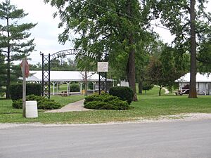
La Belle has a city park called Johnson Park. You can find it where Wood Street and Main Street meet. There is also a baseball field on the west side of town, near Highway 6. Many local teams play their summer games there.
During hunting seasons, many people visit La Belle. They come to hunt animals like white-tail deer and turkey in the nearby areas. The Missouri Department of Conservation manages a 112-acre (0.45 square kilometer) lake south of La Belle. This lake used to provide drinking water for the city from 1980 to 2003.
La Belle also has a public library branch. It has been open since 1935. In 1964, it became part of the Northeast Missouri Library Service.
Education in La Belle
Students in La Belle attend schools run by the Lewis County C-1 School district. Young people from La Belle go to Highland Elementary School. They also attend Highland Junior-Senior High School, which is located in Ewing, Missouri. The city also has the Labelle Branch Library, which is a public library.
See also
 In Spanish: La Belle (Misuri) para niños
 | William Lucy |
 | Charles Hayes |
 | Cleveland Robinson |


