Clark County, Missouri facts for kids
Quick facts for kids
Clark County
|
|
|---|---|

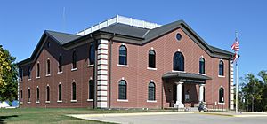
Clark County Courthouse in Kahoka
|
|

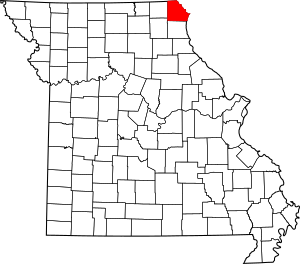
Location within the U.S. state of Missouri
|
|
 Missouri's location within the U.S. |
|
| Country | |
| State | |
| Founded | December 16, 1836 |
| Named for | William Clark |
| Seat | Kahoka |
| Largest city | Kahoka |
| Area | |
| • Total | 512 sq mi (1,330 km2) |
| • Land | 505 sq mi (1,310 km2) |
| • Water | 7.1 sq mi (18 km2) 1.4% |
| Population
(2020)
|
|
| • Total | 6,634 |
| • Density | 12.957/sq mi (5.003/km2) |
| Time zone | UTC−6 (Central) |
| • Summer (DST) | UTC−5 (CDT) |
| Congressional district | 6th |
Clark County is a place in the state of Missouri, USA. In 2020, about 6,634 people lived there. The main town, or county seat, is Kahoka.
The county was created on December 16, 1836. It is named after William Clark, a famous explorer. He was a leader of the Lewis and Clark Expedition and later became a governor of the Missouri area. Clark County is part of a larger area that includes towns like Fort Madison and Keokuk in Iowa and Illinois.
Contents
History
Early settlers were drawn to Clark County because the land was good for farming. It was also very inexpensive. One area was even called "Bit Nation." This was because land there sold for only about twelve and a half cents an acre. This amount was known as "one bit" of a Spanish dollar.
Geography
Clark County covers about 512 square miles (1,326 square kilometers). Most of this area, about 505 square miles, is land. The rest, about 7.1 square miles, is water.
Neighboring Counties
Clark County shares its borders with several other counties:
- Van Buren County, Iowa (to the north)
- Lee County, Iowa (to the northeast)
- Hancock County, Illinois (to the east)
- Lewis County (to the south)
- Knox County (to the southwest)
- Scotland County (to the west)
Main Roads
These are the major highways that run through Clark County:
Protected Natural Areas
Part of the Great River National Wildlife Refuge is located in Clark County. This is a special area set aside to protect wildlife.
Population Information
| Historical population | |||
|---|---|---|---|
| Census | Pop. | %± | |
| 1840 | 2,846 | — | |
| 1850 | 5,527 | 94.2% | |
| 1860 | 11,684 | 111.4% | |
| 1870 | 13,667 | 17.0% | |
| 1880 | 15,031 | 10.0% | |
| 1890 | 15,126 | 0.6% | |
| 1900 | 15,383 | 1.7% | |
| 1910 | 12,811 | −16.7% | |
| 1920 | 11,874 | −7.3% | |
| 1930 | 10,254 | −13.6% | |
| 1940 | 10,166 | −0.9% | |
| 1950 | 9,003 | −11.4% | |
| 1960 | 8,725 | −3.1% | |
| 1970 | 8,260 | −5.3% | |
| 1980 | 8,493 | 2.8% | |
| 1990 | 7,547 | −11.1% | |
| 2000 | 7,416 | −1.7% | |
| 2010 | 7,139 | −3.7% | |
| 2020 | 6,634 | −7.1% | |
| U.S. Decennial Census 1790-1960 1900-1990 1990-2000 2010-2015 |
|||
In 2010, there were 7,139 people living in Clark County. There were about 2,966 households, which are groups of people living together. The population density was about 15 people per square mile. Most of the people living in the county were White (98.83%).
About 25% of the population was under 18 years old. The average age of people in the county was 39 years.
Education
Clark County has both public and private schools for students.
Public Schools
The Clark County R-I School District serves students in the area. Its main office is in Kahoka.
- Running Fox Elementary School (Grades PK-5)
- Black Hawk Elementary School (Grades K-5)
- Clark County Middle School (Grades 6-8)
- Clark County High School (Grades 9-12)
Private Schools
- Shiloh Christian School in Kahoka (Grades 3-12) is a private Christian school.
Public Libraries
The Northeast Missouri Library Service helps provide books and resources to the community.
Communities
Clark County has several towns and villages where people live.
Cities
- Alexandria
- Kahoka (This is the county seat, the main town for county government)
- Revere
- Wayland
- Wyaconda
Villages
Census-designated Places
These are areas that are like towns but are not officially incorporated as cities or villages.
Other Unincorporated Places
See also
 In Spanish: Condado de Clark (Misuri) para niños
 | James Van Der Zee |
 | Alma Thomas |
 | Ellis Wilson |
 | Margaret Taylor-Burroughs |


