Van Buren County, Iowa facts for kids
Quick facts for kids
Van Buren County
|
|
|---|---|
|
|
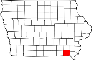
Location within the U.S. state of Iowa
|
|
 Iowa's location within the U.S. |
|
| Country | |
| State | |
| Founded | December 7, 1836 |
| Named for | Martin Van Buren |
| Seat | Keosauqua |
| Largest city | Keosauqua |
| Area | |
| • Total | 491 sq mi (1,270 km2) |
| • Land | 485 sq mi (1,260 km2) |
| • Water | 5.7 sq mi (15 km2) 1.2% |
| Population
(2020)
|
|
| • Total | 7,203 |
| • Density | 14.670/sq mi (5.664/km2) |
| Time zone | UTC−6 (Central) |
| • Summer (DST) | UTC−5 (CDT) |
| Congressional district | 2nd |
Van Buren County is a county in the state of Iowa, USA. In 2020, about 7,203 people lived here. This makes it one of the least populated counties in Iowa.
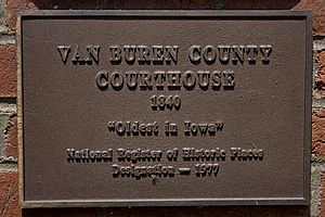
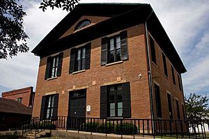
The main town and county seat is Keosauqua. It has the oldest courthouse in Iowa that is still being used. It's also the second oldest courthouse in the entire United States!
Contents
History of Van Buren County
Van Buren County was created on December 7, 1836. At that time, it was part of the Wisconsin Territory. It was separated from Des Moines County.
The county was named after Martin Van Buren, who later became a US President. On July 4, 1838, it became part of the Iowa Territory. Later, Iowa became a state.
The county's courthouse was built in September 1843. It was designed in the Greek Revival style. This building is Iowa's oldest courthouse that is still in use today. It is also the second oldest in the whole country!
The Honey War
Van Buren County has a fun story from its past called "The Honey War." This happened when the border between Missouri and the Wisconsin Territory was not clear. Missouri tried to collect taxes from people living north of a line called the Sullivan Line. But the people said Missouri had no right to tax them.
The sheriff from Van Buren County arrested the sheriff from Kahoka, Missouri. Missourians were also accused of "stealing honey from bee trees." This happened in what is now Lacey-Keosauqua State Park.
Both governors sent troops to solve the problem. But luckily, no one was hurt or killed. The US Congress then stepped in to help. The border problem was finally fixed in 1846 when Iowa became a state. Congress decided that the original Sullivan Line was correct, favoring Iowa.
Local Arts
Van Buren County is also home to Iowa's oldest community theater group. It's called the "Van Buren Players." This group started performing in 1963 and is still active today!
Geography
Van Buren County covers about 491 square miles. Most of this area, about 485 square miles, is land. The rest, about 5.7 square miles, is water.
Main Roads
Neighboring Counties
- Jefferson County (north)
- Henry County (northeast)
- Lee County (east)
- Clark County, Missouri (southeast)
- Scotland County, Missouri (southwest)
- Davis County (west)
Population Information
| Historical population | |||
|---|---|---|---|
| Census | Pop. | %± | |
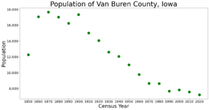
| 1850 | 12,270 | — | |
| 1860 | 17,081 | 39.2% | |
| 1870 | 17,672 | 3.5% | |
| 1880 | 17,043 | −3.6% | |
| 1890 | 16,253 | −4.6% | |
| 1900 | 17,354 | 6.8% | |
| 1910 | 15,020 | −13.4% | |
| 1920 | 14,060 | −6.4% | |
| 1930 | 12,603 | −10.4% | |
| 1940 | 12,053 | −4.4% | |
| 1950 | 11,007 | −8.7% | |
| 1960 | 9,778 | −11.2% | |
| 1970 | 8,643 | −11.6% | |
| 1980 | 8,626 | −0.2% | |
| 1990 | 7,676 | −11.0% | |
| 2000 | 7,809 | 1.7% | |
| 2010 | 7,570 | −3.1% | |
| 2020 | 7,203 | −4.8% | |
| 2023 (est.) | 7,266 | −4.0% | |
| U.S. Decennial Census 1790-1960 1900-1990 1990-2000 2010-2018 |
|||
Recent Census Data (2020)
In 2020, the county had 7,203 people. This means there were about 14.7 people for every square mile. Most people (97.24%) reported being of one race. About 94.53% were non-Hispanic White.
There were 3,500 homes in the county, and 2,984 of them were lived in.
Older Census Data (2010)
In 2010, there were 7,570 people living in Van Buren County. There were 3,108 households, which are groups of people living together in a home. About 25.4% of these homes had children under 18.
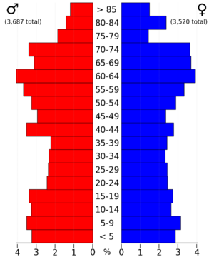
The population was spread out by age. About 24.1% of people were under 18 years old. And 19.8% of people were 65 years or older. The average age was 43.3 years.
Communities
Cities
Census-Designated Places (CDPs)
These are areas that are like towns but are not officially incorporated as cities.
Unincorporated Communities
These are small communities that do not have their own local government.
- Iowaville
- Lebanon
- Mt. Zion
- Pittsburg
- Selma
- Winchester
Townships
Townships are smaller areas within a county, often used for local administration. Here are the townships from the 1850 US Census Records:
- Birmingham Township
- Bonaparte Township
- Cedar Township
- Chequest Township
- Des Moines Township
- Farmington Township
- Harrisburg Township
- Jackson Township
- Keosauqua Township
- Lick Creek Township
- Union Township
- Van Buren Township
- Vernon Township
- Village Township
- Washington Township
Population Ranking of Communities
This table shows the communities in Van Buren County, ranked by how many people lived there in 2020.
† county seat
| Rank | City/Town/etc. | Type | Population (2020 Census) |
|---|---|---|---|
| 1 | † Keosauqua | City | 936 |
| 2 | Farmington | City | 579 |
| 3 | Milton | City | 380 |
| 4 | Birmingham | City | 367 |
| 5 | Bonaparte | City | 359 |
| 6 | Stockport | City | 272 |
| 7 | Cantril | City | 224 |
| 8 | Douds | CDP | 156 |
| 9 | Leando | CDP | 121 |
| 10 | Mount Sterling | CDP | 33 |
Education
Here are the school districts that serve students in Van Buren County:
- Cardinal Community School District
- Davis County Community School District
- Fairfield Community School District
- Mount Pleasant Community School District
- Van Buren County Community School District
A former school district that used to serve the area was:
- Harmony Community School District
See also
 In Spanish: Condado de Van Buren (Iowa) para niños
 | Tommie Smith |
 | Simone Manuel |
 | Shani Davis |
 | Simone Biles |
 | Alice Coachman |


