Henry County, Iowa facts for kids
Quick facts for kids
Henry County
|
|
|---|---|

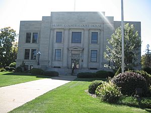
Henry County Courthouse
|
|

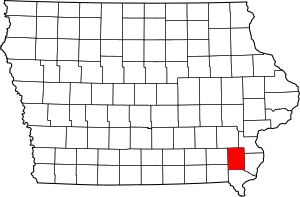
Location within the U.S. state of Iowa
|
|
 Iowa's location within the U.S. |
|
| Country | |
| State | |
| Founded | December 7, 1836 |
| Named for | Henry Dodge |
| Seat | Mount Pleasant |
| Largest city | Mount Pleasant |
| Area | |
| • Total | 437 sq mi (1,130 km2) |
| • Land | 434 sq mi (1,120 km2) |
| • Water | 2.2 sq mi (6 km2) 0.5% |
| Population
(2020)
|
|
| • Total | 20,482 |
| • Estimate
(2023)
|
19,547 |
| • Density | 46.87/sq mi (18.096/km2) |
| Time zone | UTC−6 (Central) |
| • Summer (DST) | UTC−5 (CDT) |
| Congressional district | 2nd |
Henry County is a place in Iowa, a state in the United States. It's like a big neighborhood or district. In 2020, about 20,482 people lived here. The main town, or county seat, is Mount Pleasant. The county got its name from General Henry Dodge, who was a governor of the Wisconsin Territory a long time ago.
Contents
History of Henry County
Henry County was officially created on December 7, 1836. At that time, it was part of the Wisconsin Territory. Later, on July 4, 1838, it became part of the Iowa Territory when that territory was formed. It was named after General Henry Dodge.
The first building used as a courthouse in Henry County was built between 1839 and 1840. A bigger courthouse was built in 1871. The current courthouse, which you can see today, started being used on August 4, 1914.
Geography and Location
Henry County covers a total area of about 437 square miles (1,132 square kilometers). Most of this area, about 434 square miles (1,124 square kilometers), is land. Only a small part, about 2.2 square miles (5.7 square kilometers), is water.
Main Roads in Henry County
Several important roads pass through Henry County, making it easy to travel around.
Public Transportation
- Mount Pleasant station is a train station in the county.
Neighboring Counties
Henry County shares borders with several other counties:
- Washington County to the north
- Louisa County to the northeast
- Des Moines County to the east
- Lee County to the south
- Van Buren County to the southwest
- Jefferson County to the west
Population and People

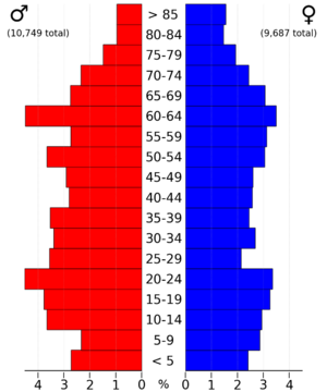
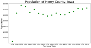
The population of Henry County changes over time. In the 2020 census, 20,482 people lived here. This means there were about 47 people living in each square mile.
Most people in Henry County reported being of one race (95.23%). There were 8,398 homes, and 7,746 of them were lived in.
Who Lives in Henry County?
Here's a look at the different groups of people living in Henry County, based on the 2020 census:
| Group | Number of People | Percentage |
|---|---|---|
| White | 17,643 | 86.14% |
| Black or African American | 501 | 2.44% |
| Native American | 60 | 0.3% |
| Asian | 451 | 2.2% |
| Pacific Islander | 8 | .04% |
| Other/Mixed (people who reported more than one race) | 736 | 3.6% |
| Hispanic or Latino (can be of any race) | 1,083 | 5.3% |
Cities and Towns
Henry County has several cities and smaller communities.
Cities in Henry County
Smaller Communities (Unincorporated)
These places are not officially cities but are still communities where people live. Some are called "CDP" which means census-designated place.
- Lowell (CDP)
- Mount Union (CDP)
- Oakland Mills
- Swedesburg (CDP)
- Tippecanoe
- Trenton (CDP)
Townships
Henry County is also divided into smaller areas called townships.
- Baltimore
- Canaan
- Center
- Jackson
- Jefferson
- Marion
- New London
- Salem
- Scott
- Tippecanoe
- Trenton
- Wayne
Biggest Communities by Population
This table shows the communities in Henry County from largest to smallest, based on the 2020 census. † means it's the county seat (the main town).
| Rank | City/Town/etc. | Type | Population (2020 Census) |
|---|---|---|---|
| 1 | † Mount Pleasant | City | 9,274 |
| 2 | New London | City | 1,910 |
| 3 | Winfield | City | 1,033 |
| 4 | Wayland | City | 964 |
| 5 | Salem | City | 394 |
| 6 | Olds | City | 192 |
| 7 | Hillsboro | City | 163 |
| 8 | Mount Union | CDP | 120 |
| 9 | Rome | City | 114 |
| 10 | Westwood | City | 101 |
| 11 | Coppock (partially in Jefferson and Washington Counties) | City | 36 |
Schools in Henry County
Students in Henry County attend schools in several different school districts:
- Danville Community School District
- Fairfield Community School District
- Fort Madison Community School District
- Mount Pleasant Community School District
- New London Community School District
- Van Buren County Community School District
- Waco Community School District
- Winfield-Mount Union Community School District
One school district that used to be in the area is the Harmony Community School District.
See also
 In Spanish: Condado de Henry (Iowa) para niños
 | Toni Morrison |
 | Barack Obama |
 | Martin Luther King Jr. |
 | Ralph Bunche |


