Louisa County, Iowa facts for kids
Quick facts for kids
Louisa County
|
|
|---|---|

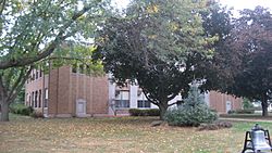
Louisa County Courthouse in Wapello
|
|

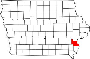
Location within the U.S. state of Iowa
|
|
 Iowa's location within the U.S. |
|
| Country | |
| State | |
| Founded | 1836 |
| Seat | Wapello |
| Largest city | Wapello |
| Area | |
| • Total | 418 sq mi (1,080 km2) |
| • Land | 402 sq mi (1,040 km2) |
| • Water | 16 sq mi (40 km2) 3.8% |
| Population
(2020)
|
|
| • Total | 10,837 |
| • Density | 25.93/sq mi (10.010/km2) |
| Time zone | UTC−6 (Central) |
| • Summer (DST) | UTC−5 (CDT) |
| Congressional district | 2nd |
Louisa County (/luˈaɪzə/ loo-EYE-zə) is a county located in the U.S. state of Iowa. It's like a smaller region within the state. As of the 2020 census, about 10,837 people lived there. The main town, or "county seat," where the government offices are, is Wapello.
Louisa County is also part of a larger area around Muscatine. This area is called the Muscatine Micropolitan Statistical Area.
Contents
History of Louisa County
Louisa County was officially created on December 7, 1836. At that time, it was part of the Wisconsin Territory.
How Louisa County Got Its Name
There are two main ideas about how Louisa County got its name:
- Some people believe it was named after Louisa Massey. She was well-known in the area. She bravely got justice for her brother after he was murdered.
- Others think it was named after Louisa County, Virginia.
On July 4, 1838, Louisa County became part of the new Iowa Territory.
The Courthouses of Louisa County
The county has had several courthouses over the years:
- The very first courthouse was a simple building made of wood.
- In 1840, a second courthouse was built. It was made of stone and was about 40 feet long and 20 feet wide.
- A third building was constructed in 1854.
- The courthouse that is used today was built in 1928. It's where important county business happens.
Geography of Louisa County
Louisa County covers a total area of about 418 square miles. Most of this area, about 402 square miles, is land. The remaining 16 square miles (about 3.8%) is water. The eastern side of the county is right next to the famous Mississippi River.
Main Roads in Louisa County
These are some of the important highways that pass through Louisa County:
Neighboring Counties
Louisa County shares borders with several other counties:
- To the northwest: Johnson County
- To the north: Muscatine County
- To the northeast: Rock Island County, Illinois
- To the east: Mercer County, Illinois
- To the south: Des Moines County
- To the southwest: Henry County
- To the west: Washington County
Protected Natural Areas
Part of the Port Louisa National Wildlife Refuge is located in Louisa County. This is a special area set aside to protect wildlife and their natural homes.
Population of Louisa County
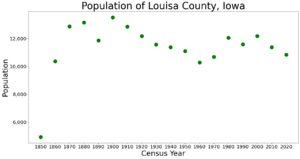
| Historical population | |||
|---|---|---|---|
| Census | Pop. | %± | |
| 1850 | 4,939 | — | |
| 1860 | 10,370 | 110.0% | |
| 1870 | 12,877 | 24.2% | |
| 1880 | 13,142 | 2.1% | |
| 1890 | 11,873 | −9.7% | |
| 1900 | 13,516 | 13.8% | |
| 1910 | 12,855 | −4.9% | |
| 1920 | 12,179 | −5.3% | |
| 1930 | 11,575 | −5.0% | |
| 1940 | 11,384 | −1.7% | |
| 1950 | 11,101 | −2.5% | |
| 1960 | 10,290 | −7.3% | |
| 1970 | 10,682 | 3.8% | |
| 1980 | 12,055 | 12.9% | |
| 1990 | 11,592 | −3.8% | |
| 2000 | 12,183 | 5.1% | |
| 2010 | 11,387 | −6.5% | |
| 2020 | 10,837 | −4.8% | |
| 2023 (est.) | 10,513 | −7.7% | |
| U.S. Decennial Census 1790-1960 1900-1990 1990-2000 2010-2018 |
|||
2020 Census Information

In 2020, the census counted 10,837 people living in Louisa County. This means there were about 26 people per square mile. There were 4,712 housing units, and 4,180 of them were lived in.
The population of Louisa County is made up of people from many different backgrounds:
| Group | Number | Percentage |
|---|---|---|
| White (not Hispanic) | 8,485 | 78.3% |
| Black or African American (not Hispanic) | 73 | 0.7% |
| Native American (not Hispanic) | 11 | 0.1% |
| Asian (not Hispanic) | 265 | 2.5% |
| Other/Mixed (not Hispanic) | 275 | 2.54% |
| Hispanic or Latino | 1,728 | 16% |
2010 Census Information
The 2010 census showed that 11,387 people lived in Louisa County. There were 5,002 housing units, and 4,346 of them were occupied.
Towns and Communities
Louisa County has several towns and a few smaller communities.
Cities in Louisa County
Unincorporated Communities
These are smaller places that are not officially cities:
- Cairo
- Toolesboro
Population Ranking of Cities (2020 Census)
This table shows the cities in Louisa County, ranked by how many people lived there in 2020. † county seat
| Rank | City/Town | Type | Population (2020 Census) |
|---|---|---|---|
| 1 | † Wapello | City | 2,084 |
| 2 | Columbus Junction | City | 1,830 |
| 3 | Morning Sun | City | 752 |
| 4 | Grandview | City | 437 |
| 5 | Columbus City | City | 392 |
| 6 | Letts | City | 363 |
| 7 | Fredonia | City | 222 |
| 8 | Oakville | City | 200 |
| 9 | Cotter | City | 39 |
See also
 In Spanish: Condado de Louisa (Iowa) para niños
 | Kyle Baker |
 | Joseph Yoakum |
 | Laura Wheeler Waring |
 | Henry Ossawa Tanner |


