Davis County, Iowa facts for kids
Quick facts for kids
Davis County
|
|
|---|---|

|
|

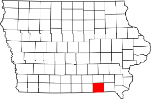
Location within the U.S. state of Iowa
|
|
 Iowa's location within the U.S. |
|
| Country | |
| State | |
| Founded | 1843 |
| Named for | Garrett Davis |
| Seat | Bloomfield |
| Largest city | Bloomfield |
| Area | |
| • Total | 505 sq mi (1,310 km2) |
| • Land | 502 sq mi (1,300 km2) |
| • Water | 2.7 sq mi (7 km2) 0.5% |
| Population
(2020)
|
|
| • Total | 9,110 |
| • Estimate
(2021)
|
9,138 |
| • Density | 18.040/sq mi (6.965/km2) |
| Time zone | UTC−6 (Central) |
| • Summer (DST) | UTC−5 (CDT) |
| Congressional district | 2nd |
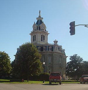
Davis County is a special area in the state of Iowa, USA. It's like a smaller region within the state. In 2020, about 9,110 people lived here. The main town and center of the county is Bloomfield.
Davis County is also part of a larger area called the Ottumwa, IA Micropolitan Statistical Area. This means it's connected to a bigger city for things like jobs and services.
Contents
Discovering Davis County's Past
Davis County got its name from a person named Garrett Davis. He was a important leader from Kentucky. Garrett Davis served in the US Congress from 1839 to 1847. Later, he became a US Senator for Kentucky.
Exploring Davis County's Geography
The U.S. Census Bureau says that Davis County covers a total area of about 505 square miles. Most of this area, about 502 square miles, is land. The rest, about 2.7 square miles, is water. That's about half a percent of the total area.
Important Roads in Davis County
These are some of the main roads that go through Davis County:
Neighboring Counties
Davis County shares its borders with several other counties:
- Wapello County (to the north)
- Monroe County (to the northwest)
- Van Buren County (to the east)
- Jefferson County (to the northeast)
- Scotland County, Missouri (to the southeast)
- Schuyler County, Missouri (to the southwest)
- Appanoose County (to the west)
Who Lives in Davis County?
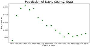
This chart shows how the population of Davis County has changed over many years. You can see if the number of people living here went up or down.
| Historical population | |||
|---|---|---|---|
| Census | Pop. | %± | |
| 1850 | 7,264 | — | |
| 1860 | 13,764 | 89.5% | |
| 1870 | 15,565 | 13.1% | |
| 1880 | 16,468 | 5.8% | |
| 1890 | 15,258 | −7.3% | |
| 1900 | 15,620 | 2.4% | |
| 1910 | 13,315 | −14.8% | |
| 1920 | 12,574 | −5.6% | |
| 1930 | 11,150 | −11.3% | |
| 1940 | 11,136 | −0.1% | |
| 1950 | 9,959 | −10.6% | |
| 1960 | 9,199 | −7.6% | |
| 1970 | 8,207 | −10.8% | |
| 1980 | 9,104 | 10.9% | |
| 1990 | 8,312 | −8.7% | |
| 2000 | 8,541 | 2.8% | |
| 2010 | 8,753 | 2.5% | |
| 2020 | 9,110 | 4.1% | |
| 2023 (est.) | 9,169 | 4.8% | |
| U.S. Decennial Census 1790-1960 1900-1990 1990-2000 2010-2018 |
|||
Davis County's Population in 2020
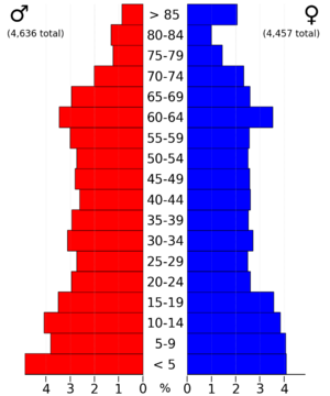
In 2020, the census counted 9,110 people living in Davis County. This means there were about 18 people for every square mile. Most people, about 97.5%, said they belonged to one race. About 95% were non-Hispanic White. Around 1.6% were Hispanic.
There were 3,579 homes in the county. Out of these, 3,258 homes were lived in.

Davis County's Population in 2010
The 2010 census showed that 8,753 people lived in Davis County. This was about 17 people per square mile. There were 3,600 homes, and 3,201 of them were occupied.
A Look at Religion in Davis County
Davis County is home to the largest group of Amish people in Iowa. As of 2024, there were 1,860 Amish members recorded here. The Amish are a group of people known for their simple lifestyle and traditional ways.
Towns and Areas in Davis County
Main Cities and Towns
These are the official cities in Davis County:
Smaller Communities
These are places where people live, but they are not officially organized as cities:
- Belknap
- Troy
- West Grove
What are Townships?
Davis County is divided into smaller areas called townships. These are like local districts that help manage the county.
- Cleveland
- Drakesville
- Fabius
- Fox River
- Grove
- Lick Creek
- Marion
- Perry
- Prairie
- Roscoe
- Salt Creek
- Soap Creek
- Union
- West Grove
- Wyacondah
How Big are the Cities?
This table shows the population of the cities in Davis County, based on the 2020 census. The city with the dagger symbol (†) is the county seat, which is the main administrative town.
| Rank | City/Town/etc. | Municipal type | Population (2020 Census) |
|---|---|---|---|
| 1 | † Bloomfield | City | 2,682 |
| 2 | Pulaski | City | 264 |
| 3 | Drakesville | City | 164 |
| 4 | Floris | City | 116 |
Famous People from Davis County
- John Pickler was a member of the United States House of Representatives. He used to live in Davis County.
Want to Learn More?
 In Spanish: Condado de Davis (Iowa) para niños
 | Stephanie Wilson |
 | Charles Bolden |
 | Ronald McNair |
 | Frederick D. Gregory |


