Schuyler County, Missouri facts for kids
Quick facts for kids
Schuyler County
|
|
|---|---|
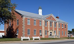
Schuyler County court house in Lancaster
|
|
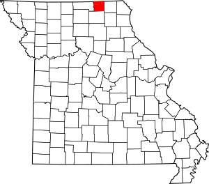
Location within the U.S. state of Missouri
|
|
 Missouri's location within the U.S. |
|
| Country | |
| State | |
| Founded | February 14, 1845 |
| Named for | Philip Schuyler |
| Seat | Lancaster |
| Largest city | Lancaster |
| Area | |
| • Total | 308 sq mi (800 km2) |
| • Land | 307 sq mi (800 km2) |
| • Water | 0.9 sq mi (2 km2) 0.3% |
| Population
(2020)
|
|
| • Total | 4,032 |
| • Density | 13.091/sq mi (5.054/km2) |
| Time zone | UTC−6 (Central) |
| • Summer (DST) | UTC−5 (CDT) |
| Congressional district | 6th |
Schuyler County is a cool place in northeastern Missouri, a state in the United States. In 2020, about 4,032 people lived here. This makes it one of the smaller counties in Missouri.
The main town and county seat is Lancaster. Schuyler County was created on February 14, 1845. It was named after General Philip Schuyler, an important leader from New York. He was a delegate to the Continental Congress and a U.S. Senator.
Schuyler County is part of the Kirksville area. Even a World War II ship, the USS Schuyler, was partly named after this county!
Contents
Exploring Schuyler County's Geography
Schuyler County covers about 308 square miles. Most of this area is land, with only a small part (0.3%) being water. It is the second-smallest county in Missouri by land area. Schuyler County shares its northern border with Iowa.
Neighboring Counties Around Schuyler
Schuyler County is surrounded by several other counties:
- Appanoose County, Iowa (to the northwest)
- Davis County, Iowa (to the northeast)
- Scotland County (to the east)
- Adair County (to the south)
- Putnam County (to the west)
Main Roads in Schuyler County
You can get around Schuyler County using these important highways:
People and Population in Schuyler County
| Historical population | |||
|---|---|---|---|
| Census | Pop. | %± | |
| 1850 | 3,287 | — | |
| 1860 | 6,697 | 103.7% | |
| 1870 | 8,880 | 32.6% | |
| 1880 | 10,470 | 17.9% | |
| 1890 | 11,249 | 7.4% | |
| 1900 | 10,840 | −3.6% | |
| 1910 | 9,062 | −16.4% | |
| 1920 | 8,383 | −7.5% | |
| 1930 | 6,951 | −17.1% | |
| 1940 | 6,627 | −4.7% | |
| 1950 | 5,760 | −13.1% | |
| 1960 | 5,052 | −12.3% | |
| 1970 | 4,665 | −7.7% | |
| 1980 | 4,979 | 6.7% | |
| 1990 | 4,236 | −14.9% | |
| 2000 | 4,170 | −1.6% | |
| 2010 | 4,431 | 6.3% | |
| 2020 | 4,032 | −9.0% | |
| U.S. Decennial Census 1790-1960 1900-1990 1990-2000 2010-2015 |
|||
In 2010, there were 4,431 people living in Schuyler County. There were 1,725 households, which are groups of people living together. About 1,193 of these were families.
The population density was about 14 people per square mile. Most people in the county (98.44%) were White. A small number of people were from other racial backgrounds. About 0.65% of the population was Hispanic or Latino.
About 29.60% of households had children under 18 living with them. Many households (59.10%) were married couples. The average household had 2.39 people.
The median age in the county was 41 years old. This means half the people were younger than 41 and half were older. About 24.60% of the population was under 18.
The median income for a household was $27,385. For families, it was $34,564. About 17.00% of the population lived below the poverty line. This included 22.10% of those under 18.
2020 Census Update
| Race | Num. | Perc. |
|---|---|---|
| White (NH) | 3,864 | 96% |
| Black or African American (NH) | 0 | 0% |
| Native American (NH) | 1 | 0.02% |
| Asian (NH) | 15 | 0.37% |
| Pacific Islander (NH) | 1 | 0.02% |
| Other/Mixed (NH) | 104 | 2.6% |
| Hispanic or Latino | 47 | 1.17% |
Education in Schuyler County
Schuyler County has public schools and a public library.
Public Schools
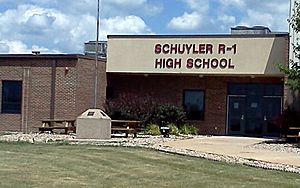
The main school district is the Schuyler County R-1 School District, located in Queen City. It includes:
- Schuyler County Elementary School (for grades K-6)
- Schuyler County Middle School (for grades 7-8)
- Schuyler County High School (for grades 9-12)
Public Libraries
- Schuyler County Library
Communities in Schuyler County
Schuyler County has several towns and one village.
Cities
- Downing
- Greentop (a small part is in Adair County)
- Lancaster (this is the county seat)
- Queen City
Village
Unincorporated Communities
These are smaller communities that are not officially organized as cities or villages:
Famous People from Schuyler County
Schuyler County has been home to some interesting people:
- Farrell Dobbs – He was a labor union leader and ran for president.
- William Preston Hall – Known as "The Colonel" or "Horse King of the World." He was famous for dealing exotic animals and breeding horses.
- Howard R. Hughes Sr. – He helped start the Hughes Tool Company. He was also the father of the famous millionaire, Howard Robard Hughes Jr..
- Rupert Hughes – A novelist and screenwriter. He was Howard Hughes Sr.'s brother and Howard Hughes Jr.'s uncle.
- Darrin Vincent – A talented bluegrass music producer and performer. He's been nominated for a Grammy award.
- Rhonda Vincent – An award-winning bluegrass music performer.
See also
 In Spanish: Condado de Schuyler (Misuri) para niños
 | Percy Lavon Julian |
 | Katherine Johnson |
 | George Washington Carver |
 | Annie Easley |


