Downing, Missouri facts for kids
Quick facts for kids
Downing, Missouri
|
|
|---|---|

Historic Downing railroad depot
|
|

Location of Downing, Missouri
|
|
| Country | United States |
| State | Missouri |
| County | Schuyler |
| Area | |
| • Total | 0.66 sq mi (1.72 km2) |
| • Land | 0.66 sq mi (1.71 km2) |
| • Water | 0.01 sq mi (0.01 km2) |
| Elevation | 873 ft (266 m) |
| Population
(2020)
|
|
| • Total | 300 |
| • Density | 455.24/sq mi (175.73/km2) |
| Time zone | UTC-6 (Central (CST)) |
| • Summer (DST) | UTC-5 (CDT) |
| ZIP code |
63536
|
| Area code(s) | 660 |
| FIPS code | 29-19990 |
| GNIS feature ID | 2394558 |
Downing is a small city located in Schuyler County, Missouri, in the United States. In 2020, about 300 people lived there. It is part of the Kirksville area, which is a group of nearby towns and cities.
Contents
History of Downing
Even though Downing officially became a town in 1872, people started settling in this area much earlier. Around 1837, a man named Henry Downing built a home and claimed land a few miles south of where the city is today.
The very first school in Schuyler County was also started near present-day Downing. In the spring of 1841, a simple log cabin was built for school use near Henry Downing's home. Miss Esther Hathaway was the first teacher there. Before it was called Downing, the small settlement was known as Cherry Grove.
Civil War Skirmish
During the American Civil War, a small fight happened near Cherry Grove on July 1, 1862. Soldiers from the pro-Union (Northern) side met a smaller group of Confederate (Southern) troops. The Confederate forces were defeated. The Union forces had one soldier seriously hurt. This event was part of a larger effort by Confederate Colonel Joseph C. Porter to gather soldiers in northeast Missouri.
Town Growth and the Railroad
In September 1872, the Missouri Town Company officially created the town plan and named it Downing. They named it after H. H. Downing, who was the president of the company. James Prime donated the land for the town, the railroad tracks, and the train station. The Missouri, Iowa, and Nebraska Railway built the train station in April 1872.
By the late 1880s, Downing was a busy place. It had many businesses like general stores, drug stores, grocery stores, and hardware stores. There were also restaurants, a blacksmith, and two hotels. Factories in Downing made things like tool handles and wagons. The town also had two large warehouses for buying and selling tobacco. At its busiest in 1902, over 155,000 pounds of tobacco were handled through Downing. The town's location on the Keokuk & Western railroad made it easy to ship goods, crops, and farm animals.
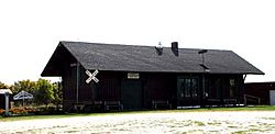
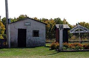
The Downing Railroad Depot is a very important historical building. It was added to the National Register of Historic Places in 1983. Today, the depot has been moved and is now a museum in a city park. Other old buildings, like the former Downing jail, are also nearby.
Geography of Downing
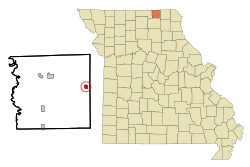
Downing is located in northeastern Missouri. The city covers a total area of about 0.67 square miles (1.72 square kilometers). Most of this area is land, with a very small part being water.
Population Information
| Historical population | |||
|---|---|---|---|
| Census | Pop. | %± | |
| 1880 | 152 | — | |
| 1890 | 406 | 167.1% | |
| 1900 | 501 | 23.4% | |
| 1910 | 513 | 2.4% | |
| 1920 | 566 | 10.3% | |
| 1930 | 514 | −9.2% | |
| 1940 | 507 | −1.4% | |
| 1950 | 453 | −10.7% | |
| 1960 | 463 | 2.2% | |
| 1970 | 406 | −12.3% | |
| 1980 | 462 | 13.8% | |
| 1990 | 359 | −22.3% | |
| 2000 | 396 | 10.3% | |
| 2010 | 335 | −15.4% | |
| 2020 | 300 | −10.4% | |
| U.S. Decennial Census | |||
Population in 2010
In 2010, there were 335 people living in Downing. These people lived in 160 homes, and 90 of these were families. The city had about 507 people per square mile.
About one-fifth of the people living in Downing were under 18 years old. About one-quarter of the residents were 65 years old or older. The average age of people in the city was about 45 years old.
See also
 In Spanish: Downing (Misuri) para niños
 | Laphonza Butler |
 | Daisy Bates |
 | Elizabeth Piper Ensley |


