Kirksville, Missouri facts for kids
Quick facts for kids
Kirksville, Missouri
|
|||
|---|---|---|---|
| City of Kirksville | |||
|
|
|||
|
|||

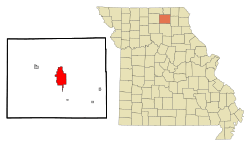
Location within Adair County and Missouri
|
|||
| Country | United States | ||
| State | Missouri | ||
| County | Adair | ||
| Township | Benton | ||
| Platted | 1841 | ||
| Incorporated | 1857 | ||
| Government | |||
| • Type | Council-manager government | ||
| Area | |||
| • Total | 14.42 sq mi (37.36 km2) | ||
| • Land | 14.39 sq mi (37.26 km2) | ||
| • Water | 0.04 sq mi (0.10 km2) | ||
| Elevation | 968 ft (295 m) | ||
| Population
(2020)
|
|||
| • Total | 17,530 | ||
| • Density | 1,218.55/sq mi (470.48/km2) | ||
| Demonym(s) | Kirksvillian | ||
| Time zone | UTC-6 (CST) | ||
| • Summer (DST) | UTC-5 (CDT) | ||
| ZIP code |
63501
|
||
| Area code | 660 | ||
| FIPS code | 29-39026 | ||
| GNIS feature ID | 2395547 | ||
| Website | kirksvillecity.com | ||
Kirksville is a city in Adair County, Missouri, in the United States. It is the main city and the county seat of Adair County. In 2020, about 17,530 people lived there. Kirksville is home to three colleges: Truman State University, Moberly Area Community College, and A.T. Still University.
Contents
History
Kirksville was first planned out in 1841. It became an official city in 1857.
How Kirksville Got Its Name
People say the town was named after Jesse Kirk. He was Kirksville's first postmaster. He also owned the first hotel and a tavern in town. The story goes that he shared a meal with surveyors. In return, they agreed to name the town after him.
Some people think the town was named after John Kirk. He was a president of Truman State University much later. But this is not true. Jesse Kirk's grandson said the town was named for Jesse's son, John. John was known for a local legend. He supposedly killed two deer with one bullet!
The Battle of Kirksville
A big battle happened in Kirksville during the American Civil War. It took place from August 6 to 9, 1862. Union soldiers, led by John McNeil, fought against Confederate volunteers. The Confederates were led by Joseph C. Porter.
The Union troops won the battle. Many Confederate soldiers were killed or hurt. Colonel McNeil, the Union leader, faced some criticism. He executed some Confederate prisoners after the battle. These prisoners had promised not to fight again.
Tornadoes in Kirksville
Kirksville has been hit by strong tornadoes.
On April 27, 1899, a very powerful tornado struck. It was an F4 tornado. It caused a lot of damage. It killed 34 people and destroyed hundreds of buildings. A popular song, "Just as the Storm Passed O'er," was written about this event.
On May 13, 2009, another large tornado hit Kirksville. This one was an EF2 tornado. It damaged or destroyed many homes and businesses. Two people living near the city were killed. About a dozen others were injured. This tornado was even shown on TV shows like Storm Chasers and Storm Stories.
Historic Places in Kirksville
Many buildings and places in Kirksville are very old and important. They are listed on the National Register of Historic Places. This means they are protected because of their history. Some of these places include:
- Adair County Courthouse
- Grim Building
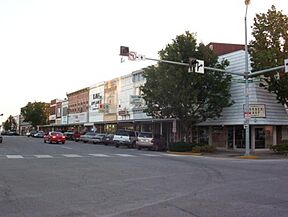
- Kirksville Courthouse Square Historic District
- Masonic Temple
- Travelers Hotel
- Trinity Episcopal Church
Geography
Kirksville covers about 14.43 square miles (37.36 square kilometers). Most of this area is land. Only a small part is water.
Kirksville's Climate
Kirksville has a climate with hot summers and cold winters. Summers are warm and humid. Winters are cold and snowy. Most rain falls in the summer. This rain often comes from thunderstorms. Sometimes, these storms can be very strong.
| Climate data for Kirksville, Missouri (1991–2020 normals, extremes 1893–present) | |||||||||||||
|---|---|---|---|---|---|---|---|---|---|---|---|---|---|
| Month | Jan | Feb | Mar | Apr | May | Jun | Jul | Aug | Sep | Oct | Nov | Dec | Year |
| Record high °F (°C) | 70 (21) |
78 (26) |
85 (29) |
93 (34) |
101 (38) |
106 (41) |
113 (45) |
111 (44) |
104 (40) |
95 (35) |
93 (34) |
74 (23) |
113 (45) |
| Mean maximum °F (°C) | 56.7 (13.7) |
62.7 (17.1) |
74.5 (23.6) |
82.1 (27.8) |
85.3 (29.6) |
91.2 (32.9) |
95.8 (35.4) |
95.6 (35.3) |
89.5 (31.9) |
82.0 (27.8) |
70.5 (21.4) |
58.7 (14.8) |
97.4 (36.3) |
| Mean daily maximum °F (°C) | 33.6 (0.9) |
38.4 (3.6) |
50.5 (10.3) |
62.4 (16.9) |
72.1 (22.3) |
81.4 (27.4) |
85.7 (29.8) |
84.3 (29.1) |
77.0 (25.0) |
64.6 (18.1) |
50.7 (10.4) |
38.6 (3.7) |
61.6 (16.4) |
| Daily mean °F (°C) | 24.3 (−4.3) |
28.7 (−1.8) |
39.8 (4.3) |
50.9 (10.5) |
61.7 (16.5) |
71.4 (21.9) |
75.6 (24.2) |
73.8 (23.2) |
65.6 (18.7) |
53.7 (12.1) |
40.7 (4.8) |
29.8 (−1.2) |
51.3 (10.7) |
| Mean daily minimum °F (°C) | 15.1 (−9.4) |
19.0 (−7.2) |
29.2 (−1.6) |
39.5 (4.2) |
51.2 (10.7) |
61.3 (16.3) |
65.5 (18.6) |
63.3 (17.4) |
54.3 (12.4) |
42.9 (6.1) |
30.7 (−0.7) |
21.1 (−6.1) |
41.1 (5.1) |
| Mean minimum °F (°C) | −4.8 (−20.4) |
−0.5 (−18.1) |
10.7 (−11.8) |
24.5 (−4.2) |
36.4 (2.4) |
48.2 (9.0) |
54.5 (12.5) |
52.2 (11.2) |
37.9 (3.3) |
26.7 (−2.9) |
14.6 (−9.7) |
−0.9 (−18.3) |
−10.5 (−23.6) |
| Record low °F (°C) | −23 (−31) |
−31 (−35) |
−13 (−25) |
8 (−13) |
22 (−6) |
37 (3) |
46 (8) |
40 (4) |
25 (−4) |
1 (−17) |
−10 (−23) |
−23 (−31) |
−31 (−35) |
| Average precipitation inches (mm) | 1.39 (35) |
2.01 (51) |
2.67 (68) |
4.09 (104) |
5.79 (147) |
5.94 (151) |
4.85 (123) |
4.16 (106) |
4.18 (106) |
3.29 (84) |
2.32 (59) |
1.78 (45) |
42.47 (1,079) |
| Average snowfall inches (cm) | 6.0 (15) |
4.6 (12) |
2.2 (5.6) |
0.8 (2.0) |
0.0 (0.0) |
0.0 (0.0) |
0.0 (0.0) |
0.0 (0.0) |
0.0 (0.0) |
0.1 (0.25) |
1.3 (3.3) |
4.0 (10) |
19.0 (48) |
| Average precipitation days (≥ 0.01 in) | 5.5 | 6.6 | 8.4 | 11.1 | 11.9 | 10.8 | 8.7 | 9.0 | 8.1 | 8.9 | 7.6 | 7.0 | 103.6 |
| Average snowy days (≥ 0.1 in) | 2.8 | 2.7 | 1.2 | 0.3 | 0.0 | 0.0 | 0.0 | 0.0 | 0.0 | 0.1 | 0.7 | 2.4 | 10.2 |
| Source: NOAA | |||||||||||||
Population and People
| Historical population | |||
|---|---|---|---|
| Census | Pop. | %± | |
| 1860 | 658 | — | |
| 1870 | 1,471 | 123.6% | |
| 1880 | 2,314 | 57.3% | |
| 1890 | 3,510 | 51.7% | |
| 1900 | 5,966 | 70.0% | |
| 1910 | 6,347 | 6.4% | |
| 1920 | 7,213 | 13.6% | |
| 1930 | 8,293 | 15.0% | |
| 1940 | 10,080 | 21.5% | |
| 1950 | 11,110 | 10.2% | |
| 1960 | 13,123 | 18.1% | |
| 1970 | 15,569 | 18.6% | |
| 1980 | 17,167 | 10.3% | |
| 1990 | 17,152 | −0.1% | |
| 2000 | 16,988 | −1.0% | |
| 2010 | 17,505 | 3.0% | |
| 2020 | 17,530 | 0.1% | |
| U.S. Decennial Census | |||
Kirksville is the main city in a larger area that includes Adair and Schuyler counties.
Who Lives in Kirksville?
In 2020, there were 17,530 people living in Kirksville. Most residents (82.28%) were white. About 7.25% were Black or African-American. About 3.65% were Asian. People of Hispanic or Latino background made up 1.9% of the population.
The average age in Kirksville was 23.7 years. This is because many young people attend the colleges there. About 17.3% of the population was under 18. A large group, 35.7%, were between 18 and 24 years old.
Congolese Community
Since 2015, many people from the Democratic Republic of the Congo have moved to Kirksville. They came to the U.S. through special visas. Many found jobs at a food facility nearby.
In 2014, only five Congolese families lived in Kirksville. By 2016, there were almost 40 families, totaling about 100 people. This led to more students in the Kirksville R-III School District needing English language help. The school district expanded its program to support them.
Students and teachers from Truman State University also helped the Congolese families. They helped them get used to life in Kirksville. Many of these new residents were well-educated. Learning English was the main challenge for them.
Education
Kirksville has three places for higher learning:
- Truman State University: This is a liberal arts school. It was once called the North Missouri Normal School and Commercial College.
- A.T. Still University: This university has the Kirksville College of Osteopathic Medicine. It was the first school for osteopathic medical and dental studies.
- Moberly Area Community College (MACC): This college has a campus in Kirksville.
Younger students attend schools run by the Kirksville R-III School District. This includes Kirksville High School.
Kirksville also has a public library, called the Adair County Public Library.
Media and News
Kirksville is part of a media market with Ottumwa, Iowa. This means they share some TV and radio stations.
Television stations include:
- KTVO (channel 3): This station shows programs from both ABC and CBS.
- K30MG-D (channel 15): This is a translator station for KYOU-TV in Ottumwa. It shows Fox, NBC, and The CW+ programs.
Radio stations include:
- KTRM: This is a student radio station from Truman State University.
- KRXL: This station plays classic rock music for the Kirksville and Ottumwa area.
For print news, Kirksville has the Kirksville Daily Express. It comes out most days of the week. Students at Truman State University also publish a weekly newspaper called the Index. Another student newspaper is The Monitor.
Truman students also create a weekly news show called News 36. You can watch it on CableOne channel 3 and on their campus station, TruTV.
Getting Around Kirksville
Public Transportation
Kirksville has a public transport system called Kirk-Tran. It offers bus service on a set route. The bus runs every hour from 7:00 AM to 6:00 PM on weekdays. On Fridays and Saturdays, it runs until 9:00 PM. There is no service on Sundays.
Trains
Kirksville used to have two train lines. Now, the closest train service is in La Plata, about 12.5 miles (20 km) away. You can catch Amtrak's Southwest Chief train there.
The old train lines in Kirksville are no longer used. The tracks were removed in the 1980s and 1990s. One old train station building still stands along Elson Street. There are plans to fix it up.
Air Travel
The City of Kirksville runs the Kirksville Regional Airport. It is about 4 miles (6 km) south of the city.
A radar base was built near Kirksville in 1952. It helped control aircraft. The Federal Aviation Administration (FAA) now uses the radar. It helps air traffic control centers guide planes flying over the region.
Sadly, there have been four fatal airplane accidents near Kirksville:
- On May 6, 1935, TWA Flight 6 crashed. Five people died, including Senator Bronson Cutting. This crash led to the creation of the Civil Aeronautics Administration.
- On May 22, 1962, Continental Airlines Flight 11 crashed. It was caused by an explosion. Some historians call this the first act of aviation terrorism.
- On October 20, 2004, Corporate Airlines Flight 5966 crashed. 13 of 15 people on board died.
- On November 5, 2013, a small plane crashed. Both people on board died.
City Services
Kirksville gets its water from two lakes: Hazel Creek Lake and Forrest Lake. Forrest Lake is part of Thousand Hills State Park.
Trash and recycling services in Kirksville are handled by Advanced Disposal. Most homes get electricity from AmerenUE. Liberty Utilities provides natural gas.
Famous People from Kirksville
Many notable people have connections to Kirksville:
- Doris Akers: A gospel singer and composer.
- Gordon Bell: An early computer engineer.
- Anthony Cistaro: An actor.
- Rusty Draper: A singer.
- Leo Goeke: An opera singer.
- Geraldine Page: An Academy Award-winning actress.
- Andrew Taylor Still: The founder of Osteopathic Medicine.
- Robert Taylor: A famous actor who lived in Kirksville as a child.
- Rhonda Vincent: An award-winning bluegrass singer.
|
See also
 In Spanish: Kirksville (Misuri) para niños
 | Aurelia Browder |
 | Nannie Helen Burroughs |
 | Michelle Alexander |


