Adair County, Missouri facts for kids
Quick facts for kids
Adair County
|
|
|---|---|

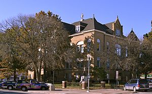
Adair County Courthouse in Kirksville
|
|

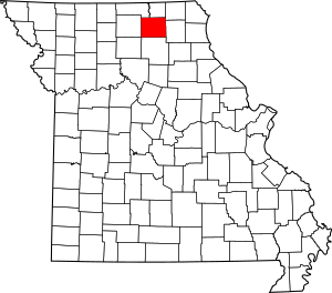
Location within the U.S. state of Missouri
|
|
 Missouri's location within the U.S. |
|
| Country | |
| State | |
| Founded | January 29, 1841 |
| Named for | Adair County, Kentucky |
| Seat | Kirksville |
| Largest city | Kirksville |
| Area | |
| • Total | 569 sq mi (1,470 km2) |
| • Land | 567 sq mi (1,470 km2) |
| • Water | 2.1 sq mi (5 km2) 0.4% |
| Population
(2020)
|
|
| • Total | 25,314 |
| • Density | 44.49/sq mi (17.177/km2) |
| Time zone | UTC−6 (Central) |
| • Summer (DST) | UTC−5 (CDT) |
| Congressional district | 6th |
Adair County is a county in the northeastern part of Missouri. In 2020, about 25,314 people lived there. The county seat, which is the main government town, is Kirksville.
Adair County was started on January 29, 1841. Many of its first settlers came from Kentucky. The county is named after Adair County, Kentucky, which was named for John Adair, a respected Governor of Kentucky.
Contents
History of Adair County
The first people to settle permanently in Adair County arrived in 1828. This was 25 years after the Louisiana Purchase, when the United States bought a huge area of land. It was also seven years after Missouri became a state. The Native American tribes, Sac and Fox, had given up their claims to the land four years earlier.
The first settlement was called "Cabins of White Folks," or just "The Cabins." It was about 6 miles (10 km) west of where Kirksville is today, along the Chariton River.
The Big Neck War
In July 1829, a group of Iowa (or Ioway) Native Americans, led by Chief Big Neck, returned to their old hunting grounds. This was against an agreement they had made. A disagreement started between some Ioway tribe members and the white settlers.
The settlers asked for help from nearby counties. Captain William Trammell arrived with about two dozen men. By then, the Ioways had moved north. Trammell's group followed them and a fight happened at a place called Battle Creek. Some people were killed on both sides, including Captain Trammell.
The surviving settlers went back to The Cabins, gathered their families, and moved south for safety. Later, a group of soldiers caught Chief Big Neck and his warriors. They were put on trial but were found not guilty and set free. This helped bring the conflict to a peaceful end.
A few months later, more white settlers returned to The Cabins and stayed for good. In 1832, the Blackhawk War caused some worry, even though the fighting was far away. To help calm fears, two small forts were built in Adair County: Fort Clark and Fort Matson. After a few months with no problems, both forts were left empty. Today, the spot where Fort Clark was is marked by a large rock and a plaque. The Fort Matson site is now a cemetery.
Adair County Courthouse
The Adair County courthouse is a large, three-story building in the middle of Kirksville. It was finished in 1899 and is built in a style called Romanesque architecture. The county didn't have its own courthouse for many years, from 1865 to 1899. They used rented spaces instead.
Finally, in 1897, voters agreed to spend $50,000 to build the current courthouse. It was a big deal because they had tried and failed four times before! The courthouse was added to the National Register of Historic Places in 1978, which means it's an important historical building.
Geography of Adair County
Adair County covers about 569 square miles (1,474 km²). Most of this area, about 567 square miles (1,469 km²), is land. Only a small part, about 2.1 square miles (5.4 km²), is water.
Rivers and Creeks
- Floyd Creek
Neighboring Counties
Adair County shares borders with these counties:
- Putnam County (to the northwest)
- Schuyler County (to the north)
- Scotland County (to the northeast)
- Knox County (to the east)
- Macon County (to the south)
- Linn County (to the southwest)
- Sullivan County (to the west)
Main Roads
Public Transportation
- Kirk-Tran
Railroads
People of Adair County (Demographics)
| Historical population | |||
|---|---|---|---|
| Census | Pop. | %± | |
| 1850 | 2,283 | — | |
| 1860 | 8,436 | 269.5% | |
| 1870 | 11,448 | 35.7% | |
| 1880 | 15,190 | 32.7% | |
| 1890 | 17,417 | 14.7% | |
| 1900 | 21,728 | 24.8% | |
| 1910 | 22,700 | 4.5% | |
| 1920 | 21,404 | −5.7% | |
| 1930 | 19,436 | −9.2% | |
| 1940 | 20,246 | 4.2% | |
| 1950 | 19,689 | −2.8% | |
| 1960 | 20,105 | 2.1% | |
| 1970 | 22,472 | 11.8% | |
| 1980 | 24,870 | 10.7% | |
| 1990 | 24,577 | −1.2% | |
| 2000 | 24,977 | 1.6% | |
| 2010 | 25,607 | 2.5% | |
| 2020 | 25,314 | −1.1% | |
| U.S. Decennial Census 1790-1960 1900-1990 1990-2000 2010-2015 |
|||
In 2000, there were about 24,977 people living in Adair County. The population density was about 44 people per square mile (17 people per km²).
The county's population was made up of different groups:
- 95.82% White
- 1.20% Black or African American
- 0.26% Native American
- 1.39% Asian
- 0.05% Pacific Islander
- 0.41% from other races
- 0.88% from two or more races.
About 1.26% of the people were Hispanic or Latino.
The median age in the county was 28 years old. This means half the people were younger than 28 and half were older.
Religion
Many people in Adair County follow a religion. The most common groups are:
- Southern Baptists (about 19.73%)
- United Methodists (about 14.27%)
- Roman Catholics (about 12.72%)
2020 Census Information
| Race | Num. | Perc. |
|---|---|---|
| White (NH) | 21,590 | 85.3% |
| Black or African American (NH) | 1,265 | 5% |
| Native American (NH) | 41 | 0.16% |
| Asian (NH) | 685 | 2.7% |
| Pacific Islander (NH) | 13 | 0.05% |
| Other/Mixed (NH) | 1,059 | 4.2% |
| Hispanic or Latino | 661 | 2.61% |
Education in Adair County
Adair County has several schools and colleges.
Public Schools
- Adair County R-I School District - Novinger
- Adair County R-I Elementary School (Grades K-6)
- Adair County R-I High School (Grades 7-12)
- Adair County R-II School District - Brashear
- Adair County R-II Elementary School (Grades K-6)
- Adair County R-II High School (Grades 7-12)
- Kirksville R-III School District - Kirksville
- Kirksville Primary School (Grades PK-2)
- Ray Miller Elementary School (Grades 3-5)
- Kirksville Middle School (Grades 6-8)
- Kirksville High School (Grades 9-12)
- La Plata R-2 School District - La Plata
- La Plata R-2 Elementary School (Grades K-6)
- La Plata R-2 High School (Grades 7-12)
- Note: These schools are in Macon County, Missouri, but their district includes parts of southern Adair County.
Private Schools
- Mary Immaculate Catholic School - Kirksville (Grades K-8) - A Roman Catholic school.
- Life Church School - Kirksville (Grades K-12) - A Nondenominational Christian school.
Colleges and Universities
- A.T. Still University - Kirksville (Known for its Kirksville College of Osteopathic Medicine)
- Truman State University - Kirksville - A public four-year university.
- Moberly Area Community College - Kirksville - A branch campus of the main college in Moberly.
Public Libraries
- Adair County Public Library
Communities in Adair County
Adair County has several cities, villages, and smaller communities.
Cities
- Brashear
- Greentop (mostly in Schuyler County)
- Kirksville (the county seat)
- Novinger
Villages
Unincorporated Communities
These are smaller places that are not officially part of a city or village.
Townships
Adair County is divided into ten areas called townships:
- Benton
- Clay
- Liberty
- Morrow
- Nineveh
- Pettis
- Polk
- Salt River
- Walnut
- Wilson
See also
 In Spanish: Condado de Adair (Misuri) para niños
 | William Lucy |
 | Charles Hayes |
 | Cleveland Robinson |

