Adair County, Kentucky facts for kids
Quick facts for kids
Adair County
|
|
|---|---|

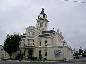
Adair County Courthouse in Columbia
|
|

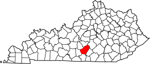
Location within the U.S. state of Kentucky
|
|
 Kentucky's location within the U.S. |
|
| Country | |
| State | |
| Founded | 1801 |
| Named for | John Adair |
| Seat | Columbia |
| Largest city | Columbia |
| Area | |
| • Total | 412 sq mi (1,070 km2) |
| • Land | 405 sq mi (1,050 km2) |
| • Water | 7.1 sq mi (18 km2) 1.7% |
| Population
(2020)
|
|
| • Total | 18,903 |
| • Estimate
(2023)
|
19,264 |
| • Density | 45.88/sq mi (17.715/km2) |
| Time zone | UTC−6 (Central) |
| • Summer (DST) | UTC−5 (CDT) |
| Congressional district | 1st |
Adair County is a county in the state of Kentucky, USA. In 2020, about 18,903 people lived there. Its main town, called the county seat, is Columbia. Columbia is also the only city in the county.
Adair County was started in 1801. It was named after John Adair. He was an important person in Kentucky, serving as the Speaker of the House and later as the Governor of Kentucky from 1820 to 1824. Adair County is special because it has some of the few remaining American Chestnut trees in the United States.
Contents
History of Adair County
Adair County was officially created on December 11, 1801. It was formed from parts of Green County. The town of Columbia was chosen as the county seat the next year. The first courthouse was built there in 1806.
The county got its name from John Adair. He was a brave soldier who fought in the Revolutionary War. He also led Kentucky troops in the famous Battle of New Orleans. Later, he became the eighth Governor of Kentucky. Adair County was the 44th of Kentucky's 120 counties to be formed.
The current courthouse in Columbia was finished in 1884. It replaced the first courthouse built in 1806.
Geography of Adair County
Adair County covers a total area of about 412 square miles (1,067 square kilometers). Most of this, about 405 square miles (1,049 square kilometers), is land. Only a small part, about 7.1 square miles (18 square kilometers), is water.
The county is part of the Pennyroyal Plateau region of Kentucky. It is also in the western part of Appalachia. More than 40% of the land in Adair County is covered with forests.
The Green River is the most important waterway in the county. However, large boats cannot travel on it. A dam on the river created Green River Lake. This lake is the main feature of Green River Lake State Park, which is partly in Adair County and partly in Taylor County.
Counties Next to Adair County
- Taylor County – to the north
- Casey County – to the northeast
- Russell County – to the east
- Cumberland County – to the south
- Metcalfe County – to the southwest
- Green County – to the northwest
Population in Adair County
| Historical population | |||
|---|---|---|---|
| Census | Pop. | %± | |
| 1810 | 6,011 | — | |
| 1820 | 8,765 | 45.8% | |
| 1830 | 8,217 | −6.3% | |
| 1840 | 8,466 | 3.0% | |
| 1850 | 9,898 | 16.9% | |
| 1860 | 9,509 | −3.9% | |
| 1870 | 11,065 | 16.4% | |
| 1880 | 13,078 | 18.2% | |
| 1890 | 13,721 | 4.9% | |
| 1900 | 14,888 | 8.5% | |
| 1910 | 16,503 | 10.8% | |
| 1920 | 17,289 | 4.8% | |
| 1930 | 16,401 | −5.1% | |
| 1940 | 18,566 | 13.2% | |
| 1950 | 17,603 | −5.2% | |
| 1960 | 14,699 | −16.5% | |
| 1970 | 13,037 | −11.3% | |
| 1980 | 15,233 | 16.8% | |
| 1990 | 15,360 | 0.8% | |
| 2000 | 17,244 | 12.3% | |
| 2010 | 18,656 | 8.2% | |
| 2020 | 18,903 | 1.3% | |
| 2023 (est.) | 19,264 | 3.3% | |
| U.S. Decennial Census 1790-1960 1900-1990 1990-2000 2010-2020 |
|||
In 2000, there were 17,244 people living in Adair County. The population density was about 42 people per square mile (16 people per square kilometer). The median age of people in the county was 37 years old.
Economy of Adair County
Adair County's economy is mostly based on farming. Farmers here raise animals like livestock, produce dairy products, and grow crops such as corn and tobacco. In the 1960s, the county also had a small oil boom, meaning they found and produced oil.
For a long time, it was hard for the county to grow because it didn't have good roads. But in 1973, the Cumberland Parkway was finished. This major road helped a lot with transportation. Since then, the county has continued to look for ways to improve its road connections, especially to the north.
Education in Adair County
The schools in Adair County are managed by the Adair County Schools system.
Here are the schools in the county:
- Adair County Primary Center
- Adair County Elementary School
- Adair County Middle School
- Adair County High School
Communities in Adair County
City
Unincorporated communities
These are smaller towns or areas that are not officially cities.
- Breeding
- Crocus (partly in Russell County)
- Glens Fork
- Gradyville
- Knifley
- Neatsville
- Pellyton
- Sparksville
- Cane Valley
- Coburg
- Holmes Bend
- Kellyville
Notable Residents of Adair County
Many interesting people have come from Adair County:
- Thomas E. Bramlette, who was a Governor of Kentucky.
- Robert Porter Caldwell (1821–1885), who served as a United States Congressman.
- E. A. Diddle, a famous men's basketball coach for Western Kentucky University.
- Janice Holt Giles (1909–1979), a writer known for her books about the region. She lived in Adair County for 30 years.
- James R. Hindman, who was a Lieutenant Governor of Kentucky.
- Sergeant Dakota Meyer (born 1988), who grew up in Adair County. In 2011, he received the Medal of Honor for his bravery.
- Pinkney H. Walker, who became the Chief Justice of the Illinois Supreme Court.
- Evelyn West, a well-known burlesque actress.
- Frank Lane Wolford, who was a U.S. Representative from Kentucky.
See also
 In Spanish: Condado de Adair (Kentucky) para niños
 | William Lucy |
 | Charles Hayes |
 | Cleveland Robinson |

