
Russell County, Kentucky facts for kids
Quick facts for kids
Russell County
|
|
|---|---|

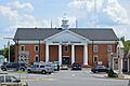
Russell County courthouse in Jamestown
|
|

Location within the U.S. state of Kentucky
|
|
 Kentucky's location within the U.S. |
|
| Country | |
| State | |
| Founded | December 14, 1825 |
| Named for | William Russell |
| Seat | Jamestown |
| Largest city | Russell Springs |
| Area | |
| • Total | 283 sq mi (730 km2) |
| • Land | 254 sq mi (660 km2) |
| • Water | 29 sq mi (80 km2) 10% |
| Population
(2020)
|
|
| • Total | 17,991 |
| • Estimate
(2023)
|
18,279 |
| • Density | 63.57/sq mi (24.55/km2) |
| Time zone | UTC−6 (Central) |
| • Summer (DST) | UTC−5 (CDT) |
| Congressional district | 1st |
Russell County is a special area in Kentucky, USA. It's like a big neighborhood with its own local government. The main town, called the county seat, is Jamestown. The biggest city in the county is Russell Springs.
In 2020, about 17,991 people lived here. Russell County was created a long time ago, on December 14, 1825. It was made from parts of other nearby counties: Adair, Cumberland, and Wayne Counties. The county is named after a person named William Russell.
In 2015, Jamestown and Russell Springs got super-fast internet. They were some of the first places in Kentucky to have this amazing optical fiber network. This means people there can get online very quickly!
Wolf Creek Dam is located in the southern part of Russell County. This dam holds back the Cumberland River to create Lake Cumberland. The lake is a huge attraction for visitors. Many people come here to enjoy the water and beautiful scenery. Right below the dam, you can also find the Wolf Creek National Fish Hatchery. This is a place where young fish are raised before being released into the water.
For a long time, Russell County was a "dry county." This meant that stores and restaurants could not sell alcohol. But on January 19, 2016, people in the county voted to change this rule. Now, alcohol can be sold there.
Contents
Exploring Russell County's Geography
Russell County covers a total area of about 283 square miles. Most of this area, about 254 square miles, is land. The rest, about 29 square miles, is water. This means about 10% of the county is covered by water.
The highest point in Russell County is called Dickerson Ridge. It's about 1,140 feet high and is in the very northern part of the county. The lowest point is about 530 feet high, along the Cumberland River.
Main Roads in Russell County
These are the most important roads that help people travel through Russell County:
- Cumberland Parkway
- U.S. Route 127 in Kentucky
- Kentucky Route 80
Neighboring Counties of Russell County
Russell County shares its borders with several other counties:
- Casey County (to the north)
- Pulaski County (to the northeast)
- Wayne County (to the southeast)
- Clinton County (to the south)
- Cumberland County (to the southwest)
- Adair County (to the west)
Population History of Russell County
| Historical population | |||
|---|---|---|---|
| Census | Pop. | %± | |
| 1830 | 3,879 | — | |
| 1840 | 4,238 | 9.3% | |
| 1850 | 5,349 | 26.2% | |
| 1860 | 6,024 | 12.6% | |
| 1870 | 5,809 | −3.6% | |
| 1880 | 7,591 | 30.7% | |
| 1890 | 8,136 | 7.2% | |
| 1900 | 9,695 | 19.2% | |
| 1910 | 10,861 | 12.0% | |
| 1920 | 11,854 | 9.1% | |
| 1930 | 11,930 | 0.6% | |
| 1940 | 13,615 | 14.1% | |
| 1950 | 13,717 | 0.7% | |
| 1960 | 11,076 | −19.3% | |
| 1970 | 10,542 | −4.8% | |
| 1980 | 13,708 | 30.0% | |
| 1990 | 14,716 | 7.4% | |
| 2000 | 16,315 | 10.9% | |
| 2010 | 17,565 | 7.7% | |
| 2020 | 17,991 | 2.4% | |
| 2023 (est.) | 18,279 | 4.1% | |
| U.S. Decennial Census 1790–1960 1900–1990 1990–2000 2010–2020 |
|||
In 2000, there were 16,315 people living in Russell County. There were 6,941 households, which are like homes where people live. About 4,796 of these were families. The population density was about 64 people for every square mile.
Most people in the county were White (98.34%). A smaller number were Black or African American (0.58%). Other groups included Native American, Asian, and Pacific Islander people. About 0.86% of the population identified as Hispanic or Latino.
About 29% of households had children under 18 living with them. Many households (55.3%) were married couples living together. About 10.2% had a female head of household without a husband present. About 28% of all households were made up of people living alone.
The average age of people in the county was 40 years old. About 22.5% of the population was under 18. About 16.5% were 65 years or older.
Towns and Communities in Russell County
Russell County has a few main towns and several smaller communities.
Cities
- Jamestown (This is the county seat, where the main government offices are)
- Russell Springs
Smaller Communities
These are smaller places that are not officially cities:
Historical Sites
- Creelsboro (This is a "ghost town," meaning it used to be a town but now very few or no people live there.)
Famous People from Russell County
Many interesting people have come from Russell County:
- Tara Conner: She was named Miss Kentucky USA in 2006 and then became Miss USA 2006.
- Vernie McGaha: He used to be a Kentucky State Senator, which means he helped make laws for the state.
- Doug Moseley: He was a pastor at a church in Russell Springs. Later, he also became a Kentucky state senator.
- Steve Wariner: A famous country music singer and songwriter. A road in Kentucky, State Route 80, is named after him!
- Jeff Hoover: A Republican member of the Kentucky House of Representatives. He was chosen as the Speaker in late 2016.
Images for kids
-
The Russell County courthouse in Jamestown, where local government business happens.
See also
 In Spanish: Condado de Russell (Kentucky) para niños
