Green River (Kentucky) facts for kids
Quick facts for kids Green River |
|
|---|---|

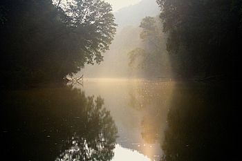
Green River near Mammoth Cave National Park
|
|

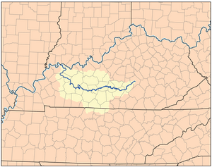
Green River Watershed
|
|
| Country | United States |
| Physical characteristics | |
| Main source | Lincoln and Casey counties in Kentucky 205 m (673 ft) |
| River mouth | Ohio River 110 m (360 ft) |
| Length | 384 mi (618 km) |
| Basin features | |
| Basin size | 25,400 km2 (9,800 sq mi) |
The Green River is a long river in Kentucky. It flows for about 384 miles (618 km). This river is a branch, or tributary, of the Ohio River. It starts in Lincoln County in south-central Kentucky. Other rivers that flow into the Green River include the Barren River, Nolin River, Pond River, and Rough River. The river got its name from Nathanael Greene. He was a general during the American Revolutionary War.
Contents
History of the Green River
After the American Revolutionary War, many soldiers received land along the Green River. This land was their payment for fighting in the war. The area also attracted many people who wandered from place to place. Because of this, the river valley was sometimes called "Rogue's Harbor."
In 1842, people made the Green River easier for boats to use. They built a series of locks and dams. These structures created a clear path for boats. This allowed boats to travel far inland, all the way to Bowling Green, Kentucky. Four locks and dams were built on the Green River. One more was built on the Barren River. The Barren River is a branch of the Green River that flows through Bowling Green.
Civil War and River Changes
During the American Civil War, a Confederate general named John Hunt Morgan led daring raids. He rode his troops through the Green River area. From there, he even reached into southern Indiana and Ohio.
Later, in 1901, two more locks and dams opened on the Green River. This allowed boats to travel to Mammoth Cave. Mammoth Cave National Park was created in 1941. The two upper locks and dams closed in 1950. In 1965, Lock and Dam #4 at Woodbury broke. This dam controlled both the Green and Barren rivers.
In 1969, the United States Army Corps of Engineers created Green River Lake. They did this by building a dam that held back a section of the river. The lake is about 8,200 acres (33 km²) in size. Today, this lake is the main part of Green River Lake State Park.
Native American Presence
There is still one Native American tribe living near the Green River. This tribe is called the Southern Cherokee Nation of Kentucky. In 1893, the governor at that time, John Y. Brown (1835–1904), officially recognized them as an Indian tribe.
The River's Path
The Green River flows through Mammoth Cave National Park. This park is located along miles 188 to 210 of the river. The river helps drain the cave system. It also controls the main water level inside Mammoth Cave. In 1906, a 9-foot (2.7 m) dam was built at Brownsville. This dam raised the water level in some parts of the cave. The higher water level likely kept Mammoth Cave connected to the nearby Flint Ridge Cave system. A drought later lowered the water, showing the connection. This made Mammoth Cave over 360 miles (580 km) long.
In 2017, several groups worked together to close and remove Green River Lock and Dam #6. This happened after a hole was found in the dam. Now, the Green River flows freely through Mammoth Cave National Park. However, water levels are still affected by water released from Green River Lake upstream. This change has made it easier for people to go canoeing and kayaking. It has also added more land to the National Park.
Transportation and Industry
The Green River is 384 miles (618 km) long. It is an important way to transport goods for the coal industry. Boats can travel on the river up to the closed Lock and Dam #3. This dam is also known as the Rochester Dam. It is at mile 108.5 of the river. In 2019, there were plans to fix Lock and Dam #3. They also planned to raise the water level behind it by up to three feet.
Muhlenberg County used to produce the most coal in the nation. It benefits a lot from having access to the river. The aluminium industry in Henderson County also uses the river. In 2002, more than 10 million short tons of goods were shipped on the river. These goods were mainly coal, petroleum coke, and aluminum ore.
River's Journey
The Green River starts near Kings Mountain, Kentucky. It then winds its way along, collecting water from smaller streams. It is then held back by a dam at Green River Lake near Campbellsville. After the lake, it continues flowing west. The Little Barren River joins it before it enters Mammoth Cave National Park. At the eastern end of the park, the Nolin River flows into it. The Nolin River comes from Nolin River Lake.
The Green River then keeps going west. The Barren River joins it next. After that, it turns more towards the northwest. It flows through western Kentucky. The river used to provide cooling water for the TVA Paradise Fossil Plant. This power plant was near Drakesboro, Kentucky, but it is now shut down. Near Sebree, the Green River still provides cooling water for the Robert Reed Power Station. This is a coal-fired power plant. Finally, the Green River empties into the Ohio River at Spottsville, Kentucky.
Biology of the Green River
The Green River is home to many different kinds of animals. It has more than 150 types of fish. It also has over 70 types of mussels. Some of Kentucky's largest fish live here. Also, some of the world's rarest mussel species can be found in the Green River.
Mussels
Some mussels in the Green River are endangered. This means they are at risk of disappearing forever. Others are threatened, meaning they could become endangered soon.
- Endangered species:
- Ring Pink Obovaria retusa
- Rough Pigtoe Pleurobema plenum
- Northern riffleshell Epioblasma torulosa rangiana
- Threatened species:
- Long solid Mussel Fusconaia subrotunda
- Pink Mucket Lampsilis abrupta
- Pyramid Pigtoe Pleurobema rubrum
 | Misty Copeland |
 | Raven Wilkinson |
 | Debra Austin |
 | Aesha Ash |

