Lincoln County, Kentucky facts for kids
Quick facts for kids
Lincoln County
|
|
|---|---|

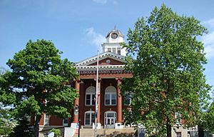
Lincoln County courthouse in Stanford
|
|

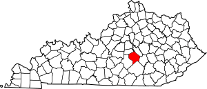
Location within the U.S. state of Kentucky
|
|
 Kentucky's location within the U.S. |
|
| Country | |
| State | |
| Founded | 1780 |
| Named for | Benjamin Lincoln |
| Seat | Stanford |
| Largest city | Stanford |
| Area | |
| • Total | 337 sq mi (870 km2) |
| • Land | 334 sq mi (870 km2) |
| • Water | 2.5 sq mi (6 km2) 0.7% |
| Population
(2020)
|
|
| • Total | 24,275 |
| • Estimate
(2023)
|
24,776 |
| • Density | 72.03/sq mi (27.81/km2) |
| Time zone | UTC−5 (Eastern) |
| • Summer (DST) | UTC−4 (EDT) |
| Congressional district | 5th |
Lincoln County is a county in south-central Kentucky. In 2020, about 24,275 people lived here. Its main town, or county seat, is Stanford. Lincoln County is part of the Danville area.
Contents
History of Lincoln County
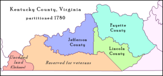
Lincoln County was created in June 1780. It was first called Lincoln County, Virginia. The Virginia General Assembly (which is like Virginia's state government) named it after Benjamin Lincoln. He was a general during the American Revolutionary War.
Lincoln County was one of three counties made from a larger area called Kentucky County. The other two were Fayette and Jefferson. This makes Lincoln County one of Kentucky's nine original counties.
The county's first main town was Harrodsburg. But in 1785, Lincoln County was divided. Harrodsburg then became the main town for the new Mercer County. After that, Stanford became the permanent main town for Lincoln County.

Geography of Lincoln County
Lincoln County covers about 337 square miles. Most of this area, about 334 square miles, is land. The rest, about 2.5 square miles, is water.
The county is in south-central Kentucky. It sits near the southern part of the Knobs region. This area has many small, rounded hills. The Knobs separate the Bluegrass region from the Eastern Pennyroyal Plateau. The Green River starts in Lincoln County. Lincoln County is also part of a larger area called Appalachia.
Neighboring Counties
- Boyle County (to the northwest)
- Garrard County (to the northeast)
- Rockcastle County (to the east)
- Pulaski County (to the south)
- Casey County (to the west)
People of Lincoln County
| Historical population | |||
|---|---|---|---|
| Census | Pop. | %± | |
| 1790 | 6,548 | — | |
| 1800 | 8,621 | 31.7% | |
| 1810 | 8,676 | 0.6% | |
| 1820 | 9,979 | 15.0% | |
| 1830 | 11,002 | 10.3% | |
| 1840 | 10,187 | −7.4% | |
| 1850 | 10,093 | −0.9% | |
| 1860 | 10,647 | 5.5% | |
| 1870 | 10,947 | 2.8% | |
| 1880 | 15,080 | 37.8% | |
| 1890 | 15,962 | 5.8% | |
| 1900 | 17,059 | 6.9% | |
| 1910 | 17,897 | 4.9% | |
| 1920 | 16,481 | −7.9% | |
| 1930 | 17,687 | 7.3% | |
| 1940 | 19,859 | 12.3% | |
| 1950 | 18,668 | −6.0% | |
| 1960 | 16,503 | −11.6% | |
| 1970 | 16,663 | 1.0% | |
| 1980 | 19,053 | 14.3% | |
| 1990 | 20,045 | 5.2% | |
| 2000 | 23,361 | 16.5% | |
| 2010 | 24,742 | 5.9% | |
| 2020 | 24,275 | −1.9% | |
| 2023 (est.) | 24,776 | 0.1% | |
| U.S. Decennial Census 1790-1960 1900-1990 1990-2000 2010-2020 |
|||
In 2000, there were 23,361 people living in Lincoln County. Most people (about 94%) were White. About 2.5% were Black or African American. A small number of people were from other groups. About 0.9% of the population was Hispanic or Latino.
There were 9,206 households. About 34% of these households had children under 18 living with them. Many households (about 59%) were married couples living together. About 24% of all households were single people living alone.
The average age of people in the county was 36 years old. About 26% of the population was under 18. About 13% were 65 years or older. For every 100 females, there were about 96 males.
The average income for a household in the county was about $39,833. For families, the average income was about $32,284. Some families in the county had lower incomes.
Towns and Places
Lincoln County has several towns and smaller communities.
Cities
- Crab Orchard
- Eubank (partly in Pulaski County)
- Hustonville
- Junction City (mostly in Boyle County)
- Stanford (This is the county's main town)
Special Places (Census-designated place)
Other Small Communities
- Blue Lick
- Chicken Bristle
- Dog Walk
- Halls Gap
- Highland
- Hubble
- Jumbo
- Kings Mountain
- Miracle
- Moreland
- Ottenheim
- Preachersville
- Rowland
- Turkeytown
- Walnut Flat
- Waynesburg
See also
 In Spanish: Condado de Lincoln (Kentucky) para niños
 | Sharif Bey |
 | Hale Woodruff |
 | Richmond Barthé |
 | Purvis Young |


