Hustonville, Kentucky facts for kids
Quick facts for kids
Hustonville, Kentucky
|
||
|---|---|---|

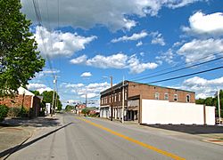
Main Street (KY 78) in Hustonville
|
||
|
||

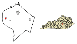
Location of Hustonville in Lincoln County, Kentucky.
|
||
| Country | United States | |
| State | Kentucky | |
| County | Lincoln | |
| Established | 1836 | |
| Incorporated | 1850 | |
| Area | ||
| • Total | 0.74 sq mi (1.91 km2) | |
| • Land | 0.74 sq mi (1.91 km2) | |
| • Water | 0.00 sq mi (0.00 km2) | |
| Elevation | 1,034 ft (315 m) | |
| Population
(2020)
|
||
| • Total | 387 | |
| • Density | 524.39/sq mi (202.51/km2) | |
| Time zone | UTC-5 (Eastern (EST)) | |
| • Summer (DST) | UTC-4 (EDT) | |
| ZIP code |
40437
|
|
| Area code(s) | 606 | |
| FIPS code | 21-38836 | |
| GNIS feature ID | 2404750 | |
Hustonville is a small city located in Lincoln County, Kentucky, in the United States. It is known as a "home rule-class city." This means it has the power to make its own local laws and decisions. In 2020, about 387 people lived there. Hustonville is part of the Danville Micropolitan Statistical Area, which is a group of nearby towns and cities that are connected economically.
Contents
History of Hustonville
Early Names and Settlement
Hustonville was first known as The Crossroads. This was because it was a meeting point for important trails. These trails connected the Kentucky and Green rivers. They also linked the Falls of the Ohio with Logan's Fort (now Stanford).
Later, the community was called Farmington. In 1818, a post office was built there. After that, it became known as Hanging Fork. This unusual name came from a local stream. The stream was named after two bandits who were dealt with by Virginia officers. For a short time in 1826, the town was called New Store. But then, its name went back to Hanging Fork.
Becoming Hustonville
The town officially became Hustonville on February 29, 1836. It was named after two local landowners. The post office also adopted the new name the following year. In 1850, the city was formally recognized by the state assembly. This made it an official city.
Building a Community
A man named William Logan Williams helped the community a lot. The local church needed a proper place to worship. So, Williams raised $6,000 to build a large church building. This church was finished in 1855. It still stands today as a reminder of his hard work.
Encouraged by this success, Williams decided to do more. He raised another $12,000 to build a college. This college was called Christian College. It was a beautiful brick building, about 100 feet long and 50 feet wide. It had three stories.
Notable People
After graduating from Centre College in Danville, Kentucky in 1889, Augustus O. Stanley taught at Christian College. He was a very important person. He later became a member of the U.S. House of Representatives and the U.S. Senate. He even served as the governor of Kentucky.
Geography of Hustonville
Hustonville is located at specific coordinates: 37.472800 degrees North and -84.817669 degrees West. The United States Census Bureau studies areas like Hustonville. According to their information, the city covers about 0.6 square miles (1.6 square kilometers). All of this area is land, with no large bodies of water inside the city limits.
Population and People
| Historical population | |||
|---|---|---|---|
| Census | Pop. | %± | |
| 1860 | 215 | — | |
| 1870 | 320 | 48.8% | |
| 1880 | 353 | 10.3% | |
| 1890 | 435 | 23.2% | |
| 1900 | 425 | −2.3% | |
| 1910 | 384 | −9.6% | |
| 1920 | 372 | −3.1% | |
| 1930 | 405 | 8.9% | |
| 1940 | 443 | 9.4% | |
| 1950 | 435 | −1.8% | |
| 1960 | 387 | −11.0% | |
| 1970 | 413 | 6.7% | |
| 1980 | 339 | −17.9% | |
| 1990 | 313 | −7.7% | |
| 2000 | 347 | 10.9% | |
| 2010 | 405 | 16.7% | |
| 2020 | 387 | −4.4% | |
| U.S. Decennial Census | |||
The population of Hustonville has changed over the years. In 2000, there were 347 people living in the city. By the 2010 census, the population had grown to 405 people. The most recent count in 2020 showed 387 residents. This means the number of people living in Hustonville has stayed fairly consistent over time.
See also
 In Spanish: Hustonville (Kentucky) para niños
 | William M. Jackson |
 | Juan E. Gilbert |
 | Neil deGrasse Tyson |


