
Rockcastle County, Kentucky facts for kids
Quick facts for kids
Rockcastle County
|
|
|---|---|

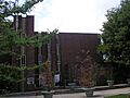
Rockcastle County courthouse in Mount Vernon
|
|

Location within the U.S. state of Kentucky
|
|
 Kentucky's location within the U.S. |
|
| Country | |
| State | |
| Founded | 1810 |
| Named for | Rockcastle River |
| Seat | Mount Vernon |
| Largest city | Mount Vernon |
| Area | |
| • Total | 318 sq mi (820 km2) |
| • Land | 317 sq mi (820 km2) |
| • Water | 1.6 sq mi (4 km2) 0.5% |
| Population
(2020)
|
|
| • Total | 16,037 |
| • Estimate
(2023)
|
16,190 |
| • Density | 50.43/sq mi (19.471/km2) |
| Time zone | UTC−5 (Eastern) |
| • Summer (DST) | UTC−4 (EDT) |
| Congressional district | 5th |
Rockcastle County is a county located in the southeastern part of Kentucky, a state in the United States. In 2020, about 16,037 people lived here. The main town and county seat is Mt. Vernon.
The county was started in 1810. It got its name from the Rockcastle River, which flows through the area. The river itself is named for the tall, rocky cliffs along its banks that look like castles. Rockcastle County is also part of a larger area that includes cities like Richmond and Lexington.
Contents
Geography
Rockcastle County covers a total area of about 318 square miles. Most of this area, about 317 square miles, is land. A small part, about 1.6 square miles, is water.
Neighboring Counties
Rockcastle County shares its borders with several other counties:
- Northwest: Garrard County
- North: Madison County
- West: Lincoln County
- East: Jackson County
- Southwest: Pulaski County
- Southeast: Laurel County
Special Natural Areas
Part of the famous Daniel Boone National Forest is located within Rockcastle County. This forest is a protected area known for its beautiful nature.
Population Information
| Historical population | |||
|---|---|---|---|
| Census | Pop. | %± | |
| 1820 | 2,249 | — | |
| 1830 | 2,865 | 27.4% | |
| 1840 | 3,409 | 19.0% | |
| 1850 | 4,697 | 37.8% | |
| 1860 | 5,343 | 13.8% | |
| 1870 | 7,145 | 33.7% | |
| 1880 | 9,670 | 35.3% | |
| 1890 | 9,841 | 1.8% | |
| 1900 | 12,416 | 26.2% | |
| 1910 | 14,473 | 16.6% | |
| 1920 | 15,406 | 6.4% | |
| 1930 | 15,149 | −1.7% | |
| 1940 | 17,165 | 13.3% | |
| 1950 | 13,925 | −18.9% | |
| 1960 | 12,334 | −11.4% | |
| 1970 | 12,305 | −0.2% | |
| 1980 | 13,973 | 13.6% | |
| 1990 | 14,803 | 5.9% | |
| 2000 | 16,582 | 12.0% | |
| 2010 | 17,056 | 2.9% | |
| 2020 | 16,037 | −6.0% | |
| 2023 (est.) | 16,190 | −5.1% | |
| U.S. Decennial Census 1790-1960 1900-1990 1990-2000 2010-2020 |
|||
The population of Rockcastle County has changed a lot over the years. In 1820, only 2,249 people lived here. The number grew steadily for many years, reaching its highest point in 2010 with 17,056 residents. By 2020, the population was 16,037.
Most people living in Rockcastle County are White. A small number of people are from other racial backgrounds. The average age of people in the county is about 36 years old.
Towns and Cities
These are the main communities in Rockcastle County:
- Brodhead
- Livingston
- Mount Vernon (This is the county seat, meaning it's where the county government is located.)
Images for kids
-
Rockcastle County courthouse in Mount Vernon
See also
 In Spanish: Condado de Rockcastle para niños
