Madison County, Kentucky facts for kids
Quick facts for kids
Madison County
|
|
|---|---|

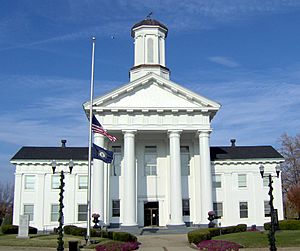
Madison County Courthouse in Richmond
|
|

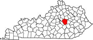
Location within the U.S. state of Kentucky
|
|
 Kentucky's location within the U.S. |
|
| Country | |
| State | |
| Founded | December 15, 1785 |
| Named for | James Madison |
| Seat | Richmond |
| Largest city | Richmond |
| Area | |
| • Total | 443 sq mi (1,150 km2) |
| • Land | 437 sq mi (1,130 km2) |
| • Water | 6.0 sq mi (16 km2) 1.3% |
| Population
(2020)
|
|
| • Total | 92,701 |
| • Estimate
(2023)
|
96,735 |
| • Density | 209.26/sq mi (80.79/km2) |
| Time zone | UTC−5 (Eastern) |
| • Summer (DST) | UTC−4 (EDT) |
| Congressional district | 6th |
Madison County is a county located in the central part of the U.S. state of Kentucky. In 2020, about 92,701 people lived here. Its main city and government center is Richmond. The county is named after James Madison, an important leader from Virginia who later became the fourth President of the United States.
Madison County is part of a larger area that includes Richmond-Berea, KY Micropolitan Statistical Area and the Lexington-Fayette–Richmond–Frankfort, KY combined statistical area.
For a long time, Madison County had rules about selling alcohol. It was considered a "moist county," meaning that while the county generally didn't allow alcohol sales, some cities within it, like Berea and Richmond, did. Also, some golf clubs could sell drinks. In 2023, the county voted to become a "wet county," meaning alcohol sales are now allowed more widely.
Madison County is home to important schools like Eastern Kentucky University and Berea College. You can also find the historic Boone Tavern here. The famous pioneer Daniel Boone once lived in Madison County and built Fort Boonesborough, which is now a state historic site you can visit.
Contents
History of Madison County
Early Explorers and Settlements
In 1769, an Indian trader named John Findley, along with Daniel Boone and four other people, explored the area that is now Madison County. They were on a hunting trip.
A few years later, in 1774, a group called the Transylvania Company, led by Judge Richard Henderson from North Carolina, bought a huge amount of land. This land, about 20 million acres, was west of the Appalachian Mountains and included what is now Madison County. They bought it from the Cherokee Nation.
Daniel Boone was then hired to create a path through the Cumberland Gap. This path helped people travel to the new lands. He also helped set up a settlement on the Kentucky River. This settlement, called Fort Boonesborough, started in April 1775.
Founding the County
In 1785, Madison County was officially created. It was formed from a part of Lincoln County, Virginia.
Geography of Madison County
According to the United States Census Bureau, Madison County covers a total area of 443 square miles. Most of this, about 437 square miles, is land. The remaining 6.0 square miles (or 1.3%) is water.
Main Roads
- Interstate 75
- U.S. 25
- U.S. 421
- KY 52
Neighboring Counties
Madison County shares borders with these other counties:
- Fayette County (to the north)
- Clark County (to the northeast)
- Estill County (to the east)
- Jackson County (to the southeast)
- Rockcastle County (to the south)
- Garrard County (to the southwest)
- Jessamine County (to the northwest)
People of Madison County (Demographics)
| Historical population | |||
|---|---|---|---|
| Census | Pop. | %± | |
| 1790 | 5,772 | — | |
| 1800 | 10,490 | 81.7% | |
| 1810 | 15,540 | 48.1% | |
| 1820 | 15,954 | 2.7% | |
| 1830 | 18,751 | 17.5% | |
| 1840 | 16,355 | −12.8% | |
| 1850 | 15,727 | −3.8% | |
| 1860 | 17,207 | 9.4% | |
| 1870 | 19,543 | 13.6% | |
| 1880 | 22,052 | 12.8% | |
| 1890 | 24,348 | 10.4% | |
| 1900 | 25,607 | 5.2% | |
| 1910 | 26,951 | 5.2% | |
| 1920 | 26,284 | −2.5% | |
| 1930 | 27,621 | 5.1% | |
| 1940 | 28,541 | 3.3% | |
| 1950 | 31,179 | 9.2% | |
| 1960 | 33,482 | 7.4% | |
| 1970 | 42,730 | 27.6% | |
| 1980 | 53,352 | 24.9% | |
| 1990 | 57,508 | 7.8% | |
| 2000 | 70,872 | 23.2% | |
| 2010 | 82,916 | 17.0% | |
| 2020 | 92,701 | 11.8% | |
| 2023 (est.) | 96,735 | 16.7% | |
| U.S. Decennial Census 1790-1960 1900-1990 1990-2000 2010-2020 |
|||
In 2000, there were 70,872 people living in Madison County. The population density was about 161 people per square mile.
Many young people live in Madison County because of the universities. In 2000, about 21.9% of the population was under 18 years old, and 18.8% were between 18 and 24 years old. The average age was 31 years. The presence of Eastern Kentucky University and Berea College helps explain why there are so many young adults here.
Education in Madison County
Schools
Madison County has two main school districts:
- Madison County Schools: This district has 10 elementary schools, 5 middle schools, and 2 high schools.
- Berea Independent Schools: This district has 1 elementary school, 1 middle school, and 1 high school.
The county is also served by Model Laboratory School, which is part of Eastern Kentucky University.
Colleges and Universities
- Eastern Kentucky University: Located in Richmond.
- Berea College: Located in Berea.
- National College of Business & Technology: Also located in Richmond.
Communities in Madison County
Cities
Other Communities
These are smaller communities in Madison County that are not officially cities:
- Baldwin
- Bighill
- Bobtown
- Boonesborough
- Buggytown
- Bybee
- College Hill
- Dreyfus
- Kingston
- Kirksville
- Million
- Moberly
- Newby
- Redhouse
- Round Hill
- Ruthton
- Speedwell
- Union City, Kentucky: This is where the entertainer Andrew Tribble was born. There's a historical marker at Union City Park to remember him.
- Valley View
- Waco
Economy
Military Presence
The Blue Grass Army Depot, a military facility, is located just south of Richmond.
Notable People from Madison County
- Frances Estill Beauchamp (1860–1923): An activist who worked for temperance (limiting alcohol) and social reform.
- Daniel S. Bentley (1850–1916): An American minister, writer, and founder of a newspaper.
- Daniel Boone: A famous American frontiersman and explorer who explored Kentucky.
- Kit Carson (1809–1868): A well-known American frontiersman.
- Mary Kavanaugh Eagle (1854–1903): An American activist, clubwoman, and book editor.
- Lonnie Napier (1940–2023): A former representative for House District 36 in the Kentucky House of Representatives.
Sister Communities
Madison County has a special connection with:
See also
 In Spanish: Condado de Madison (Kentucky) para niños
 | George Robert Carruthers |
 | Patricia Bath |
 | Jan Ernst Matzeliger |
 | Alexander Miles |

