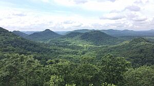
Estill County, Kentucky facts for kids
Quick facts for kids
Estill County
|
|
|---|---|
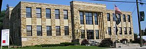
Estill County courthouse in Irvine
|
|
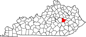
Location within the U.S. state of Kentucky
|
|
 Kentucky's location within the U.S. |
|
| Country | |
| State | |
| Founded | 1808 |
| Named for | James Estill |
| Seat | Irvine |
| Largest city | Irvine |
| Area | |
| • Total | 256 sq mi (660 km2) |
| • Land | 253 sq mi (660 km2) |
| • Water | 2.5 sq mi (6 km2) 1.0%% |
| Population
(2020)
|
|
| • Total | 14,163 |
| • Estimate
(2023)
|
13,936 |
| • Density | 55.32/sq mi (21.36/km2) |
| Time zone | UTC−5 (Eastern) |
| • Summer (DST) | UTC−4 (EDT) |
| Congressional district | 6th |
Estill County is a county located in the state of Kentucky, USA. In 2020, about 14,163 people lived there. Its main town, or county seat, is Irvine.
The county was created in 1808. It was named after Captain James Estill. He was a Kentucky soldier who died in a battle during the American Revolutionary War. In Estill County, the city of Irvine allows the sale of alcohol. However, other parts of the county outside Irvine do not.
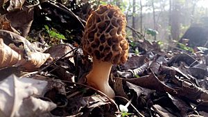
Estill County has two towns often called "twin cities." These are Irvine and Ravenna. Both towns are located along the Kentucky River. Ravenna is home to a former train facility. This facility is now used to restore old trains. Ravenna also hosts the annual Ravenna Railroad Festival. Irvine holds the yearly Mountain Mushroom Festival. This festival celebrates the many Morel Mushrooms found in the area.
Contents
History of Estill County
Estill County became Kentucky's 50th county in 1808. Land from Clark and Madison counties was used to form it. Early European settlers came to this area. They often traveled through Boonesborough.
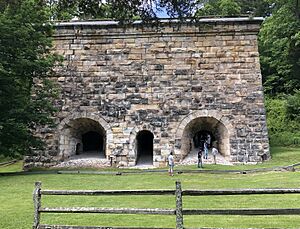
Estill County was one of the first places in the United States to have early factories. Iron mining and smelting began here in 1810. The iron industry grew strong in Estill County for many years. You can still see the old ruins of iron furnaces today. These include the Estill furnace, the Cottage furnace, and the Fitchburg Furnace. The Fitchburg furnace was very impressive. It stood 81 feet tall. It was the largest charcoal furnace in the world.
The iron industry started to decline after the American Civil War. This happened because the iron and wood needed for the furnaces ran out. Also, new technologies made charcoal furnaces old-fashioned. During the Civil War, Estill County strongly supported the Union.
The county was also known for the Estill Springs summer resort. This resort was near mineral springs in Irvine. It was a popular vacation spot in the 1800s. Famous Kentuckians like Henry Clay visited there. The current courthouse was built in 1941. It replaced an older building from the 1860s.
Geography of Estill County
Estill County covers about 256 square miles. Most of this is land (253 square miles). About 2.5 square miles is water. Estill County is where two Kentucky regions meet. These are the Bluegrass and the Cumberland Plateau. Because of this, people say it's where the "Bluegrass kisses the Mountains."
Estill County has two important rivers. The Red River forms the northern border. It is famous for its gorge in nearby Powell County. The Kentucky River flows through the middle of the county. Many of Estill County's towns, like Irvine and Ravenna, are built along the Kentucky River.
The county's landscape is very interesting. This is because of the Kentucky River's deep valley. Also, Estill County is on the edge of the Cumberland Plateau. The Pottsville Escarpment is a big feature here. It marks the line between the Bluegrass and the mountains. The land changes a lot in height. The highest point is Zion Mountain, at 1,511 feet. The lowest point is where the Kentucky River and Red River meet, at 566 feet.
Rivers and Streams
- Drowning Creek
Neighboring Counties
- Clark County (north)
- Powell County (northeast)
- Lee County (southeast)
- Jackson County (south)
- Madison County (west)
Protected Natural Areas
- Daniel Boone National Forest (part)
- Lilly Mountain Nature Preserve
People of Estill County
| Historical population | |||
|---|---|---|---|
| Census | Pop. | %± | |
| 1810 | 2,082 | — | |
| 1820 | 3,507 | 68.4% | |
| 1830 | 4,618 | 31.7% | |
| 1840 | 5,535 | 19.9% | |
| 1850 | 5,985 | 8.1% | |
| 1860 | 6,886 | 15.1% | |
| 1870 | 9,198 | 33.6% | |
| 1880 | 9,860 | 7.2% | |
| 1890 | 10,836 | 9.9% | |
| 1900 | 11,669 | 7.7% | |
| 1910 | 12,273 | 5.2% | |
| 1920 | 15,569 | 26.9% | |
| 1930 | 17,079 | 9.7% | |
| 1940 | 17,978 | 5.3% | |
| 1950 | 14,677 | −18.4% | |
| 1960 | 12,466 | −15.1% | |
| 1970 | 12,752 | 2.3% | |
| 1980 | 14,495 | 13.7% | |
| 1990 | 14,614 | 0.8% | |
| 2000 | 15,307 | 4.7% | |
| 2010 | 14,672 | −4.1% | |
| 2020 | 14,163 | −3.5% | |
| 2023 (est.) | 13,936 | −5.0% | |
| U.S. Decennial Census 1790-1960 1900-1990 1990-2000 2010-2020 |
|||
In 2000, there were 15,307 people living in Estill County. The population density was about 60 people per square mile. Most of the people were White (99.07%).
The median age in the county was 37 years old. About 24.20% of the people were under 18. About 13.50% were 65 or older.
Towns and Communities
Cities
Other Communities
- Barnes Mountain
- Cobhill
- Cressy
- Crystal
- Drip Rock
- Fox
- Furnace
- Hargett
- Leighton
- Palmer
- Patsey
- Pryse
- Red Lick
- South Irvine
- Spout Springs
- Tipton Ridge
- Wisemantown
- Winston
See also
 In Spanish: Condado de Estill para niños
 | Delilah Pierce |
 | Gordon Parks |
 | Augusta Savage |
 | Charles Ethan Porter |


