Lee County, Kentucky facts for kids
Quick facts for kids
Lee County
|
|
|---|---|

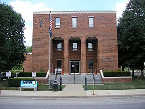
Lee County courthouse in Beattyville
|
|

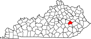
Location within the U.S. state of Kentucky
|
|
 Kentucky's location within the U.S. |
|
| Country | |
| State | |
| Founded | 1870 |
| Named for | Robert E. Lee |
| Seat | Beattyville |
| Largest city | Beattyville |
| Area | |
| • Total | 211 sq mi (550 km2) |
| • Land | 209 sq mi (540 km2) |
| • Water | 2.4 sq mi (6 km2) 1.1% |
| Population
(2020)
|
|
| • Total | 7,395 |
| • Estimate
(2023)
|
7,293 |
| • Density | 35.05/sq mi (13.53/km2) |
| Time zone | UTC−5 (Eastern) |
| • Summer (DST) | UTC−4 (EDT) |
| Congressional district | 5th |
Lee County is a county found in the state of Kentucky in the United States. In 2020, about 7,395 people lived there. The main town and county seat is Beattyville.
Lee County was created in 1870. It was formed from parts of nearby counties like Breathitt, Estill, Owsley, and Wolfe. The county was named after Robert E. Lee. Even though this area of Kentucky supported the Union during the Civil War, the government that created the county was led by former Confederates.
The first county seat was a town called Proctor. It was named after a person named Rev. Joseph Proctor. The very first court meeting happened on April 25, 1870, in an old house. Back then, the local economy included things like coal mining, gathering salt, cutting timber, and other businesses.
The current county seat, Beattyville, was first known as Taylor's Landing. This was because it was a place where people could cross the Kentucky River by ferry. In 1850, it was renamed Beatty after an early settler named Samuel Beatty. The town officially became Beattyville in 1872. It was chosen as the new county seat because its location on the river made it easy for travel and trade.
Contents
Geography of Lee County
Lee County covers a total area of about 211 square miles. Most of this area, about 209 square miles, is land. A small part, about 2.4 square miles, is water.
Eastern Kentucky Coal Field Region
Lee County is located in the Eastern Coal Field region of Kentucky. This area is known for its very rugged and hilly land. About half of the county is part of the Daniel Boone National Forest.
Timber and coal are still important for the economy here. Oil and natural gas are also found. In the past, some mining and logging methods caused harm to the environment. People are still working to fix these problems. An invasive plant called kudzu has also caused issues, but people are working to control it. The growing interest in protecting the environment and the rise of tourism are helping to encourage more action.
Counties Next to Lee County
- Powell County (north)
- Wolfe County (northeast)
- Breathitt County (southeast)
- Owsley County (south)
- Jackson County (southwest)
- Estill County (northwest)
Protected Natural Areas
- Daniel Boone National Forest (part of it is in Lee County)
Population of Lee County
| Historical population | |||
|---|---|---|---|
| Census | Pop. | %± | |
| 1880 | 4,254 | — | |
| 1890 | 6,205 | 45.9% | |
| 1900 | 7,988 | 28.7% | |
| 1910 | 9,531 | 19.3% | |
| 1920 | 11,918 | 25.0% | |
| 1930 | 9,729 | −18.4% | |
| 1940 | 10,860 | 11.6% | |
| 1950 | 8,739 | −19.5% | |
| 1960 | 7,420 | −15.1% | |
| 1970 | 6,587 | −11.2% | |
| 1980 | 7,754 | 17.7% | |
| 1990 | 7,422 | −4.3% | |
| 2000 | 7,916 | 6.7% | |
| 2010 | 7,719 | −2.5% | |
| 2020 | 7,395 | −4.2% | |
| 2023 (est.) | 7,293 | −5.5% | |
| U.S. Decennial Census 1790–1960 1900–1990 1990–2000 2010–2021 |
|||
According to the census from 2000, there were 7,916 people living in Lee County. There were 2,985 households and 2,122 families. The county had about 38 people per square mile.
About 22.70% of the people were under 18 years old. About 14.30% were 65 years or older. The average age in the county was 37 years.
Economy of Lee County
Lee County, Kentucky, has faced economic challenges. In 2014, a significant portion of its population lived with lower incomes compared to the national average.
Communities in Lee County
City
- Beattyville (This is the county seat)
Unincorporated Communities
These are smaller towns or areas that are not officially organized as cities.
- Airedale
- Athol
- Bear Track
- Belle Point
- Canyon Falls
- Congleton
- Cressmont
- Crystal
- Delvinta
- Earnestville
- Enoch
- Evelyn
- Fillmore
- Fincastle
- Fixer
- Greeley
- Heidelberg
- Idamay
- Leeco
- Lower Buffalo
- Maloney
- Monica
- Mount Olive
- Old Landing
- Primrose
- Proctor
- Saint Helens
- Standing Rock
- Tallega
- White Ash
- Williba
- Willow Shoals
- Yellow Rock
- Zacharia
- Zoe
See also
 In Spanish: Condado de Lee (Kentucky) para niños
 | Bessie Coleman |
 | Spann Watson |
 | Jill E. Brown |
 | Sherman W. White |

