
Owsley County, Kentucky facts for kids
Quick facts for kids
Owsley County
|
|
|---|---|

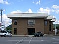
Owsley County courthouse in Booneville
|
|

Location within the U.S. state of Kentucky
|
|
 Kentucky's location within the U.S. |
|
| Country | |
| State | |
| Founded | 1843 |
| Named for | William Owsley |
| Seat | Booneville |
| Largest city | Booneville |
| Area | |
| • Total | 198 sq mi (510 km2) |
| • Land | 197 sq mi (510 km2) |
| • Water | 0.9 sq mi (2 km2) 0.4% |
| Population
(2020)
|
|
| • Total | 4,051 |
| • Estimate
(2023)
|
4,001 |
| • Density | 20.46/sq mi (7.899/km2) |
| Time zone | UTC−5 (Eastern) |
| • Summer (DST) | UTC−4 (EDT) |
| Congressional district | 5th |
Owsley County is a county found in the eastern part of Kentucky. It is part of the Eastern Coalfield region. In 2020, about 4,051 people lived there. This makes it one of the least populated counties in Kentucky.
The main town and county seat is Booneville. The county was created on January 23, 1843. It was formed from parts of Clay, Estill, and Breathitt counties. Owsley County is named after William Owsley (1782–1862). He was a judge and also the Governor of Kentucky from 1844 to 1848.
Contents
History of Owsley County
Owsley County became Kentucky's 96th county in 1843. It was named after Governor William Owsley. Later, some of its land was used to form Jackson County in 1858. More land was used for Lee County in 1870.
First Settlers
The first people to settle in Owsley County were John Renty Baker and John Abner. They arrived around 1780. They settled near what is now the Clay County line. A gravestone shows that Milly, John Abner's wife, died in 1846.
John Renty Baker and his sons were skilled gunsmiths. They created machines to make gun barrels better. John Renty Baker's father, Robert Baker, might have helped create the famous "Kentucky Rifle".
John Renty Baker was a "Longhunter". This meant he spent more than a year at a time hunting and trapping. He hunted in Kentucky in 1766 with Daniel Boone's brother-in-law. Baker lived among the Cherokee people. He also traveled down the Cumberland River to sell furs.
After his wife passed away, Baker lived alone in a rockshelter near Buffalo Creek. He died there in 1820. He was known to have at least 21 children.
Booneville's Beginnings
James Moore Sr. was the first settler in Booneville. His home was just outside the town. His son, James Jr., built a small cabin across the river. This cabin is still standing today. It has been made larger over the years.
James Moore's land covered all of Booneville. It stretched east across the South Fork River. The area was first called Moore's Station. It was renamed Booneville in 1846. The town was named after Daniel Boone. James Moore Jr. became the first postmaster.
When the county was formed in 1843, Elias Moore gave land for the county seat. The post office opened in 1844. Owsley County lost some land to Jackson County in 1858. It lost more to Wolfe County two years later. In 1870, Lee County was formed. This made Owsley County its current size.
Early Families and Records
The Moore, Bowman, Baker, Gabbard, and Reynolds families were among the first permanent settlers. Many families today still live on the land their ancestors received. These land grants often came from Virginia. Kentucky was once part of Virginia.
Sadly, the county courthouse burned down in January 1929. This destroyed all of Owsley County's old records. Another fire happened on January 5, 1967. It badly damaged the new courthouse.
Geography
Owsley County covers about 198 square miles. Most of this is land, about 197 square miles. Only a small part, 0.9 square miles, is water. The South Fork of the Kentucky River flows through the county. Most of the rain that falls here goes into this river.
The county is located in the Eastern Mountain Coal Fields. This area is part of the Appalachian Plateau. The highest point in the county is about 1,730 feet high. It is on the southern border with Clay County. The lowest point is about 650 feet high. This is where the South Fork River crosses into Lee County.
Neighboring Counties
- Lee County (north)
- Breathitt County (east)
- Perry County (southeast)
- Clay County (south)
- Jackson County (west)
Main Roads
- Kentucky Route 30
- Kentucky Route 11
- Kentucky Route 28
Protected Areas
- Daniel Boone National Forest is partly in Owsley County. This forest includes the Red River Gorge. The gorge is a popular place for rock climbing and hiking.
Population Information
| Historical population | |||
|---|---|---|---|
| Census | Pop. | %± | |
| 1850 | 3,774 | — | |
| 1860 | 5,335 | 41.4% | |
| 1870 | 3,889 | −27.1% | |
| 1880 | 4,942 | 27.1% | |
| 1890 | 5,975 | 20.9% | |
| 1900 | 6,874 | 15.0% | |
| 1910 | 7,979 | 16.1% | |
| 1920 | 7,820 | −2.0% | |
| 1930 | 7,223 | −7.6% | |
| 1940 | 8,957 | 24.0% | |
| 1950 | 7,324 | −18.2% | |
| 1960 | 5,369 | −26.7% | |
| 1970 | 5,023 | −6.4% | |
| 1980 | 5,709 | 13.7% | |
| 1990 | 5,036 | −11.8% | |
| 2000 | 4,858 | −3.5% | |
| 2010 | 4,755 | −2.1% | |
| 2020 | 4,051 | −14.8% | |
| 2023 (est.) | 4,001 | −15.9% | |
| U.S. Decennial Census 1790–1960 1900–1990 1990–2000 2010–2021 |
|||
In 2010, there were 4,755 people living in Owsley County. Most people living here are White. About 32.6% of homes had children under 18. Many homes were married couples living together. The average age of people in the county was 38 years old.
Economy
Natural Resources
In the past, deep coal mines provided many jobs. Today, this is not as common. There are some surface coal mining sites in the county. One mine can be seen north of Booneville.
Gas and oil wells are also found in the county. Many are on the north side. However, not many are working right now.
Timber is an important part of the local economy. There used to be a sawmill in the Lerose community. You can still see places where timber is gathered for processing.
Education
The public schools in Owsley County are run by the Owsley County School District. There is also one Christian private school. Sugar Camp Baptist Church has a school facility.
Attractions
Abraham Lincoln Relief Sculpture
The Abraham Lincoln Relief Sculpture is a cool piece of art. People also call it Abe Lincoln Rock. It is located near Highway 846 in the Conkling community. This sculpture is listed in the Smithsonian American Art Museum.
A traveling peddler named Granville Johnson carved the sculpture. He did this in the 1930s. The story says that Johnson was sick when he came to Owsley County. The John Williams family helped him get better. As he recovered, Mr. Johnson would carve the rock each day. He made the sculpture as a thank-you gift to the family.
The Owsley County Fiscal Court bought the sculpture and land in 2008. It can be a bit hard to find. There are no signs telling visitors where it is.
Cemeteries
- Baker-Amis Cemetery
- Botner Cemetery
- Callahan Cemetery
- Clark-Scott Cemetery
- Cortland Cemetery
- Elijah Isaacs Graveyard
- Griffith Cemetery
- Gross Cemetery
- Horn Hill Cemetery
- John Tyler Brewer Cemetery
- King Cemetery
- Lerose Cemetery
- McIntosh Cemetery
- Morris Cemetery
- Noble Cemetery
- Pendergrass Cemetery
- Shepherd Cemetery
- Stewart Cemetery
- Island City Community Cemetery (maintained by the 1st Baptist Church of Island City)
Communities
City
- Booneville (county seat)
Unincorporated communities
- Arnett
- Big Springs
- Blake
- Brewer Neighborhood
- Chestnut Gap
- Conkling
- Couch Fork
- Couch Town
- Cowcreek
- Elk Lick
- Endee
- Eversole
- Fish Creek
- Hall
- Hogg
- Indian Creek
- Island City
- Lerose
- Levi
- Lucky Fork
- Major
- Mistletoe
- Moors
- Needmore
- Pebworth
- Pleasant
- Ricetown
- Rock Spring
- Rockhouse
- Scoville
- Sebastian
- Shephard
- Southfork
- Stacey
- Stay
- Sturgeon
- Sugar Camp
- Taft
- Travellers Rest
- Vincent
- Whoopflarea
Notable Residents
Earle Combs

Earle Bryan Combs was born on May 13, 1899, in Pebworth, Owsley County. He played baseball for the New York Yankees from 1924 to 1935. He was put into the Baseball Hall of Fame in 1970.
Earle was a great leadoff hitter. He played with famous players like Babe Ruth and Lou Gehrig. He usually got almost 200 hits each season. His career batting average was .325. A plaque honors his birthplace on Highway 11 in Pebworth.
Combs left Owsley County in 1917 to go to school. After that, he did not return to live there for long. He settled in Richmond, KY in 1954 after his baseball career.
Daniel Boone

According to a book by Joyce Wilson, Daniel Boone visited Owsley County. He was on a two-year hunting trip from 1769 to 1771. He came back in 1784 to survey land for James Moore.
Boone used a large rock at Sexton's Creek as a starting point. He carved his initials into this rock. This rock is called "Boone Rock" or "Goose Rock." It is about nine miles south of Booneville on Highway 11 South. The initials are now under water because the creek has changed course.
Boone liked this area very much. He called it "a place where peace crowns the sylvan shade." He owned land here. Part of his land stayed in his family until 1819.
Daniel Boone's favorite camping spot was called the "old encampment." It is south of Booneville, near the highway and the river. Later in life, Daniel Boone found that many of his land claims were not valid. This was because others had officially claimed the land before him.
Daniel Boone's granddaughter, Leah Schull Newman, is buried in the Newnam Cemetery. This cemetery is in the Pebworth area. Other Boone family members are also buried there.
Images for kids
-
Owsley County courthouse in Booneville
-
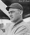
Combs playing for the Louisville Colonels
-
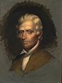
Daniel Boone
See also
 In Spanish: Condado de Owsley para niños
