Clay County, Kentucky facts for kids
Quick facts for kids
Clay County
|
|
|---|---|

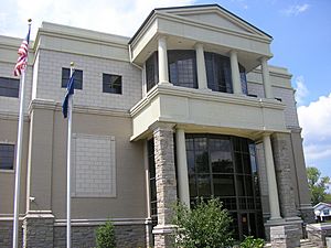
Clay County courthouse in Manchester
|
|

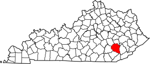
Location within the U.S. state of Kentucky
|
|
 Kentucky's location within the U.S. |
|
| Country | |
| State | |
| Founded | 1807 |
| Named for | Green Clay |
| Seat | Manchester |
| Largest city | Manchester |
| Area | |
| • Total | 471 sq mi (1,220 km2) |
| • Land | 469 sq mi (1,210 km2) |
| • Water | 1.8 sq mi (5 km2) 0.4%% |
| Population
(2020)
|
|
| • Total | 20,345 |
| • Estimate
(2023)
|
19,648 |
| • Density | 43.20/sq mi (16.678/km2) |
| Time zone | UTC−5 (Eastern) |
| • Summer (DST) | UTC−4 (EDT) |
| Congressional district | 5th |
Clay County is a county located in the state of Kentucky in the United States. In 2020, about 20,345 people lived here. The county seat, which is like the main town for government, is Manchester.
Clay County was created in 1807. It was named after Green Clay, who was an important person in Kentucky's early history. He was a relative of Henry Clay, a famous U.S. Senator and Secretary of State.
Contents
History of Clay County
Clay County was formed in 1807 from parts of three other counties: Floyd, Knox, and Madison. An important event in its history was when the county courthouse burned down in January 1936.
Geography of Clay County
Clay County covers a total area of about 471 square miles. Most of this area is land, with a small part being water.
Neighboring Counties
Clay County shares its borders with several other counties:
- Owsley County (to the north)
- Perry County (to the northeast)
- Leslie County (to the east)
- Bell County (to the southeast)
- Knox County (to the southwest)
- Laurel County (to the west)
- Jackson County (to the northwest)
Rivers and Creeks
Many important water bodies flow through Clay County. These include:
Population Facts
| Historical population | |||
|---|---|---|---|
| Census | Pop. | %± | |
| 1810 | 2,398 | — | |
| 1820 | 4,393 | 83.2% | |
| 1830 | 3,548 | −19.2% | |
| 1840 | 4,607 | 29.8% | |
| 1850 | 5,421 | 17.7% | |
| 1860 | 6,652 | 22.7% | |
| 1870 | 8,297 | 24.7% | |
| 1880 | 10,222 | 23.2% | |
| 1890 | 12,447 | 21.8% | |
| 1900 | 15,364 | 23.4% | |
| 1910 | 17,789 | 15.8% | |
| 1920 | 19,795 | 11.3% | |
| 1930 | 18,526 | −6.4% | |
| 1940 | 23,901 | 29.0% | |
| 1950 | 23,116 | −3.3% | |
| 1960 | 20,748 | −10.2% | |
| 1970 | 18,481 | −10.9% | |
| 1980 | 22,752 | 23.1% | |
| 1990 | 21,746 | −4.4% | |
| 2000 | 24,556 | 12.9% | |
| 2010 | 21,730 | −11.5% | |
| 2020 | 20,345 | −6.4% | |
| 2023 (est.) | 19,648 | −9.6% | |
| U.S. Decennial Census 1790–1960 1900–1990 1990–2000 2010–2020 |
|||
In 2010, there were 21,730 people living in Clay County. The population density was about 52 people per square mile. The average age of people living in the county was 35 years old.
Towns and Communities
Clay County has one main city and several smaller communities.
City
- Manchester (This is the county seat)
Census-Designated Places
These are areas that are like towns but are not officially incorporated as cities:
Unincorporated Towns and Villages
These are smaller communities that are not officially part of a city or census-designated place:
- Big Creek
- Fall Rock
- Garrard
- Goose Rock
- Hubbardsville
- Sibert
Post Offices
Many communities in Clay County have had, or still have, their own post offices. Here are a few examples:
See also
 In Spanish: Condado de Clay (Kentucky) para niños
 | Claudette Colvin |
 | Myrlie Evers-Williams |
 | Alberta Odell Jones |

