Manchester, Kentucky facts for kids
Quick facts for kids
Manchester, Kentucky
|
|
|---|---|

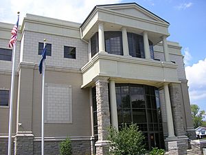
Clay County Courthouse in Manchester, Kentucky
|
|
| Motto(s):
The City of Hope
|
|

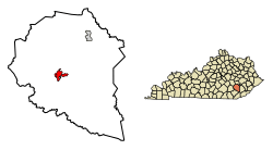
Location of Manchester in Clay County, Kentucky.
|
|
| Country | United States |
| State | Kentucky |
| County | Clay |
| Incorporated | February 6, 1844 |
| Named for | the English industrial town |
| Government | |
| • Type | Mayor-Council |
| Area | |
| • Total | 2.96 sq mi (7.65 km2) |
| • Land | 2.93 sq mi (7.58 km2) |
| • Water | 0.03 sq mi (0.07 km2) |
| Elevation | 869 ft (265 m) |
| Population
(2020)
|
|
| • Total | 1,512 |
| • Estimate
(2022)
|
1,459 |
| • Density | 516.57/sq mi (199.44/km2) |
| Time zone | UTC-5 (Eastern (EST)) |
| • Summer (DST) | UTC-4 (EDT) |
| ZIP code |
40962
|
| Area code(s) | 606 |
| FIPS code | 21-49656 |
| GNIS feature ID | 0513768 |
Manchester is a city in Clay County, Kentucky, United States. It's known as a "home rule-class city," which means it has the power to govern itself in many ways. Manchester is the main town, or seat, of Clay County. It is also home to a federal prison. In 2010, about 1,255 people lived there.
Contents
A Look Back: Manchester's History
Manchester was founded in 1807. It was created to be the main town for the newly formed Clay County. The town was built on a 10-acre piece of land near the Lower Goose Creek Salt Works.
The county court first decided to name the town Greenville. This was to honor Green Clay, a general from the War of 1812. He was the person who gave the county its name. However, there was already a town called Greenville in another county. So, the name was changed to "Manchester" in December.
There's a local story that the town was named after the hometown of General Theophilus Toulmin Garrard's second wife. But it's more likely that local business people wanted a name that reminded everyone of the successful industrial city of Manchester, England. They hoped their new town would also become a busy and important place.
Where is Manchester Located?
Manchester is located in Kentucky. Its exact coordinates are 37 degrees, 9 minutes, 10 seconds North and 83 degrees, 45 minutes, 48 seconds West. This helps pinpoint its location on a map.
The United States Census Bureau says that the city covers about 1.5 square miles (3.9 square kilometers). All of this area is land.
Who Lives in Manchester?
| Historical population | |||
|---|---|---|---|
| Census | Pop. | %± | |
| 1880 | 97 | — | |
| 1900 | 398 | — | |
| 1910 | 626 | 57.3% | |
| 1940 | 1,509 | — | |
| 1950 | 1,706 | 13.1% | |
| 1960 | 1,868 | 9.5% | |
| 1970 | 1,664 | −10.9% | |
| 1980 | 1,838 | 10.5% | |
| 1990 | 1,634 | −11.1% | |
| 2000 | 1,738 | 6.4% | |
| 2010 | 1,255 | −27.8% | |
| 2020 | 1,512 | 20.5% | |
| 2022 (est.) | 1,459 | 16.3% | |
| U.S. Decennial Census | |||
In 2010, the city of Manchester had 1,255 people living there. These people lived in 579 households. A household is like a home where people live together. Out of these, 332 were families.
The population density was about 836.7 people per square mile. This means that for every square mile of land, there were about 836 people. There were also 655 housing units, which are places where people can live.
Most of the people in Manchester (about 92.5%) were White. About 6.3% were African American. A small number of people were Asian or from other racial backgrounds. About 1% of the population was Hispanic or Latino.
Looking at the households, about 23.3% had children under 18 living with them. About 33.5% were married couples living together. Some households (19%) had a female head of the house with no husband present. About 42.7% of households were not families. Many people (37.8%) lived alone, and 19.2% of households had someone aged 65 or older living by themselves.
On average, there were 2.16 people in each household. For families, the average size was 2.84 people.
Learning and Libraries
Manchester has a public library called the Clay County Public Library. This library lends out books and other materials to people in the community. It's a great place for students and everyone else to learn and read!
Local Media
Manchester is home to several radio stations. These stations broadcast news, music, and other programs to the local area. The four radio stations that are based in Manchester are:
- WWXL
- WKLB
- WTBK
- WWLT
Famous People from Manchester
Manchester has been home to some notable people who have made a difference:
- Bert T. Combs – He was a judge and also served as the 50th Governor of Kentucky.
- Theophilus T. Garrard – A politician who also became a Union general during the American Civil War.
- Richie Farmer – He was a well-known basketball player for the University of Kentucky and later became Kentucky's Commissioner of Agriculture.
See also
 In Spanish: Manchester (Kentucky) para niños
 | Sharif Bey |
 | Hale Woodruff |
 | Richmond Barthé |
 | Purvis Young |

