Clay, Kentucky facts for kids
Quick facts for kids
Clay, Kentucky
|
|
|---|---|

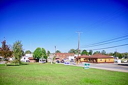
Main Street (KY 109)
|
|

Location of Clay in Webster County, Kentucky.
|
|
| Country | United States |
| State | Kentucky |
| County | Webster |
| Area | |
| • Total | 0.87 sq mi (2.25 km2) |
| • Land | 0.86 sq mi (2.23 km2) |
| • Water | 0.01 sq mi (0.02 km2) |
| Elevation | 381 ft (116 m) |
| Population
(2020)
|
|
| • Total | 1,031 |
| • Density | 1,196.06/sq mi (461.86/km2) |
| Time zone | UTC-6 (Central (CST)) |
| • Summer (DST) | UTC-5 (CDT) |
| ZIP code |
42404
|
| Area code(s) | 270 |
| FIPS code | 21-15202 |
| GNIS feature ID | 0489565 |
Clay is a small city located in Webster County, Kentucky, in the United States. It's a "home rule-class city," which means it has some power to govern itself. In 2020, about 1,031 people lived there.
The city was first settled in 1837. It is named after a famous American statesman, Henry Clay. In 2022, Clay became a "wet city" after people voted for it. This means that selling alcoholic drinks is now allowed there.
Contents
History of Clay, Kentucky
The community of Clay started with a post office in 1837. Back then, it was called Ashland. This name came from Henry Clay's large estate in Lexington.
In 1854, the town's name was changed to Clay. It officially became a city in 1860 and was called "Claysville." However, the name was made shorter to "Clay" in 1872.
Where is Clay Located?
Clay is found in Kentucky at specific geographic coordinates. These are like its address on a map. The city is mainly located where two roads, Kentucky Route 109 and Kentucky Route 132, meet.
It is northwest of another city called Providence. The city of Wheatcroft is also nearby, just to the west along KY 109. The United States Census Bureau says that Clay covers about 0.9 square miles (2.3 square kilometers) of land.
People and Population in Clay
The number of people living in Clay has changed over many years. Here's how the population has grown and shrunk:
| Historical population | |||
|---|---|---|---|
| Census | Pop. | %± | |
| 1870 | 170 | — | |
| 1880 | 248 | 45.9% | |
| 1890 | 323 | 30.2% | |
| 1900 | 450 | 39.3% | |
| 1910 | 1,098 | 144.0% | |
| 1920 | 1,378 | 25.5% | |
| 1930 | 1,551 | 12.6% | |
| 1940 | 1,429 | −7.9% | |
| 1950 | 1,291 | −9.7% | |
| 1960 | 1,343 | 4.0% | |
| 1970 | 1,426 | 6.2% | |
| 1980 | 1,356 | −4.9% | |
| 1990 | 1,173 | −13.5% | |
| 2000 | 1,179 | 0.5% | |
| 2010 | 1,181 | 0.2% | |
| 2020 | 1,031 | −12.7% | |
| U.S. Decennial Census | |||
In 2000, there were 1,179 people living in Clay. About 24.8% of the people were under 18 years old. The average age of people in Clay was 37 years.
Clay in Popular Culture
The city of Clay was mentioned in a song! The country music group The Statler Brothers released a song in 1980 called "How are Things in Clay, Kentucky?". Later, a duo named Wilson Fairchild covered this song. Wilson Fairchild is made up of the sons of two of The Statler Brothers.
Schools in Clay
Students in Clay attend public schools run by the Webster County School District.
- Clay Elementary School teaches students from Pre-School up to 6th grade. In the late 1990s, the school got a new gym and cafeteria.
- Older students go to Webster County High School in Dixon. The Middle School is also connected to the High School building.
See also
 In Spanish: Clay (Kentucky) para niños
 | William M. Jackson |
 | Juan E. Gilbert |
 | Neil deGrasse Tyson |

