Knox County, Kentucky facts for kids
Quick facts for kids
Knox County
|
|
|---|---|
|
County
|
|

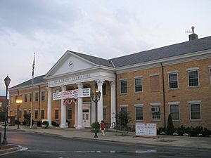
Knox County courthouse in Barbourville
|
|

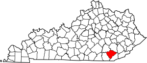
Location within the U.S. state of Kentucky
|
|
 Kentucky's location within the U.S. |
|
| Country | |
| State | |
| Founded | December 19, 1799 |
| Named for | Henry Knox |
| Seat | Barbourville |
| Largest city | Barbourville |
| Area | |
| • Total | 388 sq mi (1,000 km2) |
| • Land | 386 sq mi (1,000 km2) |
| • Water | 1.5 sq mi (4 km2) 0.4% |
| Population
(2020)
|
|
| • Total | 30,193 |
| • Estimate
(2023)
|
29,794 |
| • Density | 77.82/sq mi (30.05/km2) |
| Time zone | UTC−5 (Eastern) |
| • Summer (DST) | UTC−4 (EDT) |
| Congressional district | 5th |
Knox County is a county in the southeastern part of Kentucky. It's located in a region called Appalachia.
In 2020, about 30,193 people lived here. The main town, or county seat, is Barbourville. The county is named after General Henry Knox.
Unlike some other coal-producing areas in Kentucky, Knox County has kept many jobs and its population. It's also part of the London, KY Micropolitan Statistical Area.
Contents
History of Knox County
Knox County was created on December 19, 1799. It was formed from parts of Lincoln County.
Most people believe the county was named after Henry Knox. He was a general in the American Revolutionary War and the first United States Secretary of War.
However, some think it was named after James Knox. He was an explorer and hunter before the war. James Knox also helped build and improve the Wilderness Road, which goes through the county.
The Civil War Battle of Barbourville
A battle from the Civil War happened in Barbourville on September 19, 1861. About 800 Confederate soldiers fought against 300 Union troops.
The Union soldiers tried to protect their camp, Camp Andrew Johnson. They even removed planks from a bridge to stop the Confederates. But the larger Confederate force crossed the bridge anyway. They destroyed the camp and took the Union's weapons and supplies.
Courthouse and Economy History
The current courthouse was finished in 1964. It is the fifth courthouse the county has used.
For a long time, coal mining has been very important to Knox County's economy. Even though other mining areas in Kentucky have lost jobs and people, Knox County has managed to keep its jobs and population steady.
Geography of Knox County
Knox County covers about 388 square miles. Most of this area, 386 square miles, is land. Only a small part, about 1.5 square miles, is water.
Neighboring Counties
Knox County shares borders with these other counties:
- Clay County (to the northeast)
- Bell County (to the southeast)
- Whitley County (to the southwest)
- Laurel County (to the northwest)
Economy and Jobs
The biggest employers in Knox County are in health care and social help. Retail stores and educational services also employ many people.
The jobs that pay the most are in mining, quarrying, and oil and gas. Real estate sales and finance jobs also offer good pay.
Population Information
| Historical population | |||
|---|---|---|---|
| Census | Pop. | %± | |
| 1810 | 5,875 | — | |
| 1820 | 3,661 | −37.7% | |
| 1830 | 4,315 | 17.9% | |
| 1840 | 5,722 | 32.6% | |
| 1850 | 7,050 | 23.2% | |
| 1860 | 7,707 | 9.3% | |
| 1870 | 8,294 | 7.6% | |
| 1880 | 10,587 | 27.6% | |
| 1890 | 13,762 | 30.0% | |
| 1900 | 17,372 | 26.2% | |
| 1910 | 22,116 | 27.3% | |
| 1920 | 24,172 | 9.3% | |
| 1930 | 26,266 | 8.7% | |
| 1940 | 31,029 | 18.1% | |
| 1950 | 30,409 | −2.0% | |
| 1960 | 25,258 | −16.9% | |
| 1970 | 23,689 | −6.2% | |
| 1980 | 30,239 | 27.6% | |
| 1990 | 29,676 | −1.9% | |
| 2000 | 31,795 | 7.1% | |
| 2010 | 31,883 | 0.3% | |
| 2020 | 30,193 | −5.3% | |
| 2023 (est.) | 29,794 | −6.6% | |
| U.S. Decennial Census 1790-1960 1900-1990 1990-2000 2010-2020 |
|||
In the year 2000, there were 31,795 people living in Knox County. The population density was about 82 people per square mile.
About 26% of the people were under 18 years old. The average age was 35 years.
Education
Knox County has several public school districts for students from kindergarten through 12th grade.
K–12 Schools
Three public school districts serve the county:
- Knox County Public Schools: This district serves the entire county, including Barbourville and Corbin.
- Central Elementary (Preschool–5th grade)
- Dewitt Elementary (Preschool–5th grade)
- Flat Lick Elementary (Preschool–5th grade)
- Girdler Elementary (Preschool–5th grade)
- G.R. Hampton Elementary (Preschool–5th grade)
- Jesse D. Lay Elementary (Preschool–5th grade)
- Lynn Camp Elementary (Preschool–5th grade)
- Knox County Middle School (6th–8th grade)
- Lynn Camp High School (6th–12th grade)
- Knox Appalachian School (5th–12th grade)
- Knox Central High School (9th–12th grade)
- Knox County Learning Academy (9th–12th grade)
- Barbourville Independent School District: This district serves the city of Barbourville. It has one campus for all grades (Preschool–12th grade).
- Corbin Independent School District: This district serves the entire city of Corbin. Its boundaries cross county lines.
- Corbin Primary School (Kindergarten–2nd grade)
- Corbin Elementary (3rd–4th grade)
- Corbin Intermediate (5th–6th grade)
- Corbin Middle School (7th–8th grade)
- Corbin High School (9th–12th grade)
Colleges and Universities
Union College is a small college located in Barbourville. It is a liberal arts college connected with the Methodist church.
Communities
Cities
- Barbourville (This is the county seat, the main town)
- Corbin (Most of this city is in Whitley County)
Census-Designated Places
These are areas that are like towns but are not officially incorporated cities.
- Artemus
- Flat Lick
- North Corbin (Most of this area is in Laurel County)
Other Unincorporated Places
These are smaller communities that are not officially cities or census-designated places.
- Gray
- Kay Jay
See also
 In Spanish: Condado de Knox (Kentucky) para niños
 | Kyle Baker |
 | Joseph Yoakum |
 | Laura Wheeler Waring |
 | Henry Ossawa Tanner |

