Livingston, Kentucky facts for kids
Quick facts for kids
Livingston, Kentucky
|
|
|---|---|

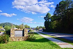
Welcome sign along US 25
|
|

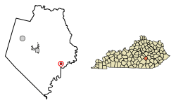
Location of Livingston in Rockcastle County, Kentucky.
|
|
| Country | United States |
| State | Kentucky |
| County | Rockcastle |
| Incorporated | 1880 |
| Reincorporated | 1943 |
| Named for | a local landowner |
| Area | |
| • Total | 0.32 sq mi (0.84 km2) |
| • Land | 0.31 sq mi (0.81 km2) |
| • Water | 0.01 sq mi (0.03 km2) |
| Elevation | 919 ft (280 m) |
| Population
(2020)
|
|
| • Total | 166 |
| • Density | 530.35/sq mi (204.92/km2) |
| Time zone | UTC-5 (Eastern (EST)) |
| • Summer (DST) | UTC-4 (EDT) |
| ZIP code |
40445
|
| Area code(s) | 606 |
| FIPS code | 21-47098 |
| GNIS feature ID | 2404943 |
Livingston is a small city in Rockcastle County, Kentucky, in the United States. It is known as a "home rule-class city," which means it has the power to manage its own local affairs. In 2020, about 166 people lived there. Livingston is part of the Richmond-Berea micropolitan area, which is a group of towns connected by jobs and daily life.
Contents
History of Livingston
The first post office in this area opened in 1840. It was called Fish Point back then.
Later, in 1870, the Louisville and Nashville Railroad (L&N) built a train station here. They named the station after James Livingston, who owned land nearby. Because of the train station, the post office changed its name to Livingston Station in 1879.
In 1880, Livingston officially became a city. Two years later, in 1882, its post office was simply renamed Livingston.
Geography and Nature
Livingston is a small city, covering about 0.3 square miles (0.8 square kilometers) of land. It is located along U.S. Route 25 in Kentucky. This road connects Livingston to Mt. Vernon, Kentucky to the northwest and London, Kentucky to the southeast.
The city's southern edge reaches the Rockcastle River. Livingston is surrounded by the beautiful Daniel Boone National Forest. This means there are lots of trees and nature around the city. The Sheltowee Trace Trail, a long hiking trail, also passes right through Livingston.
People of Livingston
| Historical population | |||
|---|---|---|---|
| Census | Pop. | %± | |
| 1900 | 605 | — | |
| 1910 | 685 | 13.2% | |
| 1920 | 703 | 2.6% | |
| 1930 | 912 | 29.7% | |
| 1940 | 669 | −26.6% | |
| 1950 | 378 | −43.5% | |
| 1960 | 419 | 10.8% | |
| 1970 | 338 | −19.3% | |
| 1980 | 334 | −1.2% | |
| 1990 | 241 | −27.8% | |
| 2000 | 228 | −5.4% | |
| 2010 | 226 | −0.9% | |
| 2020 | 166 | −26.5% | |
| U.S. Decennial Census | |||
In 2000, there were 228 people living in Livingston. Most residents were White (96.05%), and a small number were Native American (3.95%). About 3.51% of the population identified as Hispanic or Latino.
The city had 104 households. About 24% of these households had children under 18 living with them. The average household had about 2.19 people.
The median age of people in Livingston was 38 years old. This means half the people were younger than 38, and half were older. About 20.6% of the population was under 18, and 20.6% was 65 or older.
Recent Events and Culture
Livingston has a strong tradition of country, bluegrass, and spiritual music. On weekends, people often gather downtown to enjoy music and celebrate their local heritage.
In August 2021, the State Governor Andy Beshear appointed Donna Montgomery-Durham to serve as a Livingston City Commissioner. City Commissioners help make important decisions for the city.
In November 2023, a CSX freight train had an accident in Livingston. Some train cars spilled molten sulfur and caught fire. To keep everyone safe, the area was evacuated for Thanksgiving Day. Governor Beshear declared a state of emergency to help manage the situation. The fire was put out quickly, and residents were able to return home. This event made national news.
Climate in Livingston
Livingston has a climate with hot, humid summers and generally mild to cool winters. This type of weather is called a humid subtropical climate. On climate maps, you might see it labeled as "Cfa."
Notable People from Livingston
- Private First Class David Monroe Smith (1926–1950) was born in Livingston. He was a brave soldier who received the Medal of Honor for his service during the Korean War.
See also
 In Spanish: Livingston (Kentucky) para niños
 | James Van Der Zee |
 | Alma Thomas |
 | Ellis Wilson |
 | Margaret Taylor-Burroughs |

