Sheltowee Trace Trail facts for kids
Quick facts for kids Sheltowee Trace Trail |
|
|---|---|

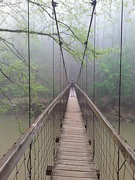
Hiker crossing the Red River
|
|
| Length | 333 miles (535.91 km) |
| Location | Kentucky and Tennessee |
| Designation | National Recreation Trail |
| Trailheads | Big South Fork National River and Recreation Area, Tennessee Rowan County, Kentucky |
| Use | Hiking |
| Difficulty | Easy to strenuous |
| Season | Year-round |
| Hazards | Severe weather American black bear Tick-borne diseases Mosquitos Yellowjackets Biting flies Chiggers Steep grades Limited water Diarrhea from water Poison ivy Venomous snakes |
The Sheltowee Trace Trail is a super long path, about 343 miles (552 km) long! It's known as a National Recreation Trail, which means it's a special place for outdoor fun. This amazing trail started in 1979. It stretches all the way from the Burnt Mill Bridge Trail Head in the Big South Fork National River and Recreation Area in Tennessee up to northern Rowan County in Kentucky.
The trail gets its unique name from a famous explorer, Daniel Boone. When he was adopted by Chief Blackfish of the Shawnee tribe, they gave him the name Sheltowee. This cool name means "Big Turtle"!
Contents
Discover the Sheltowee Trace Trail
The Sheltowee Trace Trail is an exciting adventure waiting for you! It's a long path that winds through beautiful parts of Kentucky and Tennessee. It's a special trail that lets you explore nature and see amazing sights.
What's in a Name?
Have you ever wondered where the name "Sheltowee" came from? It's a really interesting story! The trail is named after the famous American pioneer, Daniel Boone. When Daniel Boone was a young man, he was adopted by the Shawnee tribe. The great warrior Chief Blackfish gave him the name Sheltowee, which means "Big Turtle." It's a cool way to remember history while you're out on the trail!
Where Does the Trail Go?
Most of the Sheltowee Trace Trail is located within the beautiful Daniel Boone National Forest. But it doesn't stop there! The trail also takes you through other amazing places, like:
- The Big South Fork National River and Recreation Area
- Cumberland Falls State Resort Park
- Natural Bridge State Resort Park
- Two large lakes: Cave Run Lake and Laurel Lake
- Many wildlife management areas where you can spot animals
Almost all of the trail, except for the southernmost 45 miles (72 km), is in Kentucky. It's a great way to see different parts of these two states!
How Can You Use the Trail?
The Sheltowee Trace Trail is a "multi-use" trail, which means different activities are allowed on different parts of it.
- Hiking: This is the main way people enjoy the trail. You can walk for miles and explore nature.
- Horseback Riding: Some sections are open for horses, so you might see riders enjoying the path.
- Mountain Biking: Certain parts of the trail are perfect for mountain bikes, offering exciting rides.
It's important to know that not all activities are allowed everywhere. For example, off-road motorcycles and ATVs are not permitted on the trail. Always check the signs to know what's allowed in each area. In 2019, the trail was made even longer, adding 10 more miles to its path!
Staying Safe on the Trail
When you're exploring the Sheltowee Trace Trail, it's important to be prepared and stay safe. Here are some things to keep in mind:
- Weather: Be ready for different kinds of weather. Check the forecast before you go and bring appropriate gear.
- Animals: You might see wildlife like American black bears. Know what to do if you encounter animals and never approach them.
- Insects: Ticks, mosquitoes, and yellowjackets can be found on the trail. Use insect repellent and check yourself for ticks after your hike.
- Water: Always carry enough water, especially on longer hikes. If you need to drink from natural sources, make sure to filter or treat the water to avoid getting sick.
- Plants: Watch out for plants like Poison ivy that can cause itchy rashes. Learn what it looks like so you can avoid it.
- Snakes: Some snakes on the trail can be venomous. Be aware of your surroundings and give snakes plenty of space.
Always tell someone where you are going and when you expect to be back. Hiking with a friend is also a great idea!
 | James B. Knighten |
 | Azellia White |
 | Willa Brown |

