
Severe weather facts for kids
Severe weather is any dangerous kind of meteorological activity in the sky that can cause damage, knock out power, or put people in danger. The kind of bad weather that happens depends a lot on a region's latitude, its height above sea level or altitude, the shape of the land or topography, and local atmospheric conditions. Dangerous weather includes howling winds, pounding hail, and excessive precipitation like heavy rain or snow. It can spark or spread wildfires, and it fuels powerful thunderstorms, sudden air blasts called downbursts, spinning tornadoes, whirling waterspouts, huge tropical cyclones, and large extratropical cyclones. During colder months, severe events bring freezing blizzards, blinding snowstorms, and slippery ice storms, while dry regions face choking duststorms.
Severe storms are one type of extreme weather. This means they are unexpected, unusual, or out of place for that time of the year. Because of the effects of climate change, the frequency and strength of extreme events are rising. We now see more shifts in hot airflow direction, longer summer heatwaves, and harsher droughts across the globe.
Contents
Understanding What Counts as Severe Weather

Scientists who study the atmosphere are called meteorologists. They define severe weather as any storm or atmospheric condition that can put human life and property in danger. When bad weather arrives, it often requires town officials and emergency workers to step in. A stricter scientific definition often focuses on powerful events connected directly to severe thunderstorms.
The World Meteorological Organization groups severe weather into two major families: general severe weather and localized severe weather. Massive systems like Nor'easters and big European wind storms cover huge areas of land. Because they spread across whole countries or states, scientists classify them as general severe weather. In contrast, quick-hitting events like tornadoes and microbursts strike much smaller areas. Since their damage path is narrow, experts classify them as localized severe weather.
It is important to remember that severe weather is not always identical to extreme weather. Extreme weather refers to unusual events that break historical records for a specific area, like an unheard-of heat spike or an unseasonal freeze. Severe weather focuses directly on violent, damaging storms that demand fast action.
How Meteorologists Categorize Storm Strength
Forecasters split dangerous thunderstorms into three distinct ranks so families can prepare. These ranks are "approaching severe", "severe", and "significantly severe".
- Approaching severe storms produce chunks of ice between 0.5 and 1 inch across or blow winds between 50 and 58 miles per hour. In the United States, local forecasters issue a special convective Special Weather Statement to alert the public.
- Severe storms bring hail between 1 and 2 inches in diameter, blast damaging winds between 58 and 75 miles per hour, or form a tornado.
- Significant severe storms drop giant hail measuring 2 inches across or larger, unleash winds over 75 miles per hour, or generate a destructive tornado rated EF2 or higher.
When storms grow dangerous, government weather agencies step in to protect communities. In the United States, the National Weather Service issues a formal severe thunderstorm warning. Similar urgent alerts come from Environment Canada, the Australian Bureau of Meteorology, the Meteorological Service of New Zealand, and the UK Met Office. Trained spotter volunteers keep their eyes on the clouds. If someone spots a funnel cloud, or if Doppler weather radar detects a spinning strong rotation in a storm, forecasters instantly sound a high-priority tornado warning.
When ten or more tornadoes touch down over one or two days, accompanied by widespread wind damage and giant hail, forecasters classify the event as a severe weather outbreak. These dangerous storm systems can sweep across thousands of square miles in just a few hours.
How Dangerous Storms Form in the Atmosphere

Organized severe storms need the same basic ingredients that make ordinary summer thunderstorms: moist air near the ground, unstable air aloft, and an upward push. That upward push often comes when the warm sun heats the ground, creating rising bubbles of warm air called thermals. When moist surface air rises quickly, it meets freezing temperatures high above, creating strong instability.
Special atmospheric triggers can turn a simple thunderstorm into a dangerous monster. For example, a pool of sub-freezing air high in the atmosphere can freeze raindrops into giant hail. The most violent hailstorms and destructive twisters are spun by rotating storms known as supercell thunderstorms. The worst straight-line winds, called downbursts and derechos, burst out from curving lines of storms known as bow echoes. Both types of storms need plenty of wind shear, which occurs when winds blow at different speeds and directions at different altitudes.
Raging floods, giant hurricanes, spinning tornadoes, and electrical thunderstorms are among nature's most destructive natural disasters. Even though they all grow from towering cumulonimbus clouds, they develop under different conditions and across different landscapes. Scientists feed real-time measurements into complex computer models to predict where these storms will travel, helping keep towns safe.
Dangerous High Winds and Gusts

Rushing air can push with tremendous force. Even modest winds of 26 miles per hour can snap leafy tree branches, sending them crashing into electric lines and causing blackouts. Certain tree species suffer far more damage than others. Trees with shallow roots easily tip over when soil is wet. Brittle trees like eucalyptus, sea hibiscus, and avocado snap their branches under moderate strain.
Strong wind gusts can push against man-made structures in unexpected ways. If a strong gust pushes on a suspension bridge at just the right rhythm, the bridge will begin to twist. When the wind's pushes harmonize with the natural swing of the cables, the structure can shake itself apart. This mechanical failure famously caused the collapse of the original Tacoma Narrows Bridge in 1940.
Extreme winds from thunderstorms, tornadoes, or coastal hurricanes can shatter windows and blow roofs off buildings. Fast winds blowing down steep mountains can pick up sand and blast the paint right off parked cars. When swirling winds top 155 miles per hour, ordinary houses can completely collapse. To measure this damage, scientists use the Saffir–Simpson scale for ocean storms and the Enhanced Fujita scale (along with the TORRO scale in Europe) for twisters.
Twisting Tornadoes

A tornado is a rapidly spinning column of air that stretches all the way from the base of a dark cumulonimbus cloud down to the dirt. In rare moments, twisters can also hang beneath a towering cumulus cloud. Most tornadoes display a visible condensation funnel surrounded by a spinning cloud of dirt and pulverized debris.
Ordinary tornadoes spin with winds between 40 and 110 miles per hour, measuring around 250 feet across. These twisters touch down for only a few minutes, travel a mile or two, and then break apart. The most violent super-twisters are much scarier. Their howling winds can top 300 miles per hour, carve damage paths wider than two miles, and stay on the ground for dozens of miles.
Tornadoes are among the most sudden weather hazards on Earth. Most last under ten minutes, and very few survive for more than an hour. A rare few have stayed on the ground for several hours, such as the famous Tri-State Tornado of 1925. Because these storms form and vanish so quickly, scientists are constantly working to learn more about how they start.
Spinning Waterspouts

When a spinning funnel forms over a lake or ocean, it is called a waterspout. Some waterspouts are true tornadoes that moved off the shore, while others are non-supercell whirlwinds that grow upward from the warm water's surface.
Waterspouts rarely cause serious damage because they spend most of their lives over open water. However, when one moves ashore, it can toss beach chairs, rip through marinas, and tear siding off coastal houses. Once over land, friction from trees and buildings slows down the spinning winds, causing the funnel to break apart. Strong crosswinds can also blow the vortex apart. Even though they are usually weaker than land tornadoes, waterspouts can flip small fishing boats and damage large sailing ships.
Sudden Downbursts and Long-Track Derechos

A downburst happens when rain-cooled, heavy air sinks rapidly out of a storm and slams into the ground. Instead of spinning like a tornado, downburst winds blast straight outward in every direction from the crash zone. Forecasters divide these into "dry downbursts", which fall from high-based thunderstorm clouds with little rain reaching the dirt, and "wet downbursts", which drop torrential rain.
Small downbursts that cover an area less than 2.5 miles across are called Microbursts. Larger blasts are known as macrobursts. A related event called a heat burst happens near old storm boundaries called outflow boundaries or weakening squall lines. In a heat burst, dry sinking air warms up dramatically, causing surface temperatures to jump up within minutes in the middle of the night.
Downbursts create sudden shifts in wind speed and direction, known as vertical wind shear. This rapid air shift is dangerous for airplanes taking off or landing. These rapid convective blasts can push winds up to 168 miles per hour, knocking down whole forests and flattening buildings. In fact, straight-line downbursts happen ten times more often than tornadoes. When straight-line winds organize into a fast-moving, long-lasting storm system that travels hundreds of miles, meteorologists call it a Derecho.
Fast-Moving Squall Lines

A squall line is a long, continuous wall of severe thunderstorms that forms right along or ahead of an advancing cold front. These lines bring intense downpours of precipitation, falling hail, dangerous bursts of lightning, and screaming straight-line winds.
When winds push the middle of a squall line forward faster than its edges, the storm bends on radar into a bow echo. The strongest winds blast out along the forward crest of this bow. Spinning tornadoes can also sprout along waves inside the storm band where tiny low-pressure areas develop. Behind the heavy rain shield, an area called a wake low can form, occasionally triggering a sudden warm heat burst. Most wind damage from thunderstorms comes from these organized lines.
Spinning Tropical Cyclones

Giant rotating storms that form over warm tropical oceans are known scientifically as tropical cyclones. People call them hurricanes in North America and typhoons in eastern Asia. These monsters span hundreds of miles and whip up powerful ocean waves. The pounding surf can tear up underwater habitats like delicate coral reefs.
When a tropical cyclone reaches land, its winds rip down trees and destroy buildings. Coastal towns usually suffer the worst wind damage because friction over land slows the storm down. However, the storm's leftover clouds can travel hundreds of miles inland, dumping days of torrential rain and causing severe river floods.
Intense Extratropical Cyclones and Nor'easters

In Europe, cold autumn and winter winds sweeping off the North Atlantic feed large spinning storms called extratropical cyclones. These low-pressure systems bring driving rain, battering coastal waves, and fierce gales that blow down trees across the continent.
In North America, a massive synoptic-scale storm that hugs the East Coast of the United States and Atlantic Canada is called a Nor'easter. They get their name because their howling winds blow from the northeast across coastal cities of the Northeastern United States. A Nor'easter forms around a deep low-pressure area spinning just off the coastline. Its counter-clockwise rotation funnels ocean moisture right over land. These winter storms bring widespread coastal flooding, tear away beaches through coastal erosion, and drop feet of heavy snow.
Blinding Dust Storms

A dust storm is a wall of blowing sand and fine soil pushed by rushing winds. These storms happen most often in dry deserts or across farmlands suffering through long droughts. When cold storm winds rush down to the dry ground, they scoop up loose dirt and lift it thousands of feet into the sky.
Dust storms make it almost impossible to see, turning midday into dark twilight. Drivers on highways cannot see the road ahead, leading to dangerous accidents. The fine sand particles scratch the eyes and make breathing difficult by irritating the lungs. Dust storms also strip away nutrient-rich topsoil, leaving behind bare ground and reducing precious arable lands. The blowing grit scours the paint off cars and wears down the stones of historic buildings.
Raging Wildfires and Fire Clouds

Wildfires are out-of-control blazes that burn through dry forests, brush, and prairies. In places like the United States, Canada, and northern China, lightning from dry storms is a primary cause. In many other regions, fires start because of human activities like land clearing, animal husbandry, equipment sparks, or unattended campfires. In the dry Mediterranean Basin and across Australia, hot dry winds can turn a tiny spark into a massive disaster.
A wildfire can race forward at top speeds, moving over 6 miles per hour through thick forests and over 13 miles per hour through tall dry grasslands. Strong updrafts of hot air lift burning twigs and glowing embers, which scientists call firebrands. Rushing winds carry these embers over rivers, wide highways, and dirt firebreaks. When embers land on dry brush far ahead of the main fire, they ignite spot fires up to 6 miles away. In the Western United States, hotter summers and earlier melting snowpacks have made wildfire seasons longer and more dangerous.
Falling Chunks of Ice: Hailstorms

A hailstorm is a severe thunderstorm that drops balls or irregular lumps of solid ice called hailstones. While hailstorms can strike almost anywhere, they develop most often across warm temperate plains and inside tropical monsoon thunderstorms.
Hail begins as tiny frozen water drops inside tall thunderclouds (cumulonimbus). Violent updrafts of rising air keep the ice floating high where temperatures are well below freezing. As the ice ball is tossed up and down, it collects layers of supercooled liquid water that freeze instantly onto its surface. Eventually, the hailstone grows too heavy for the updraft to support. It plunges toward the ground, picked up and sped up by storm downdrafts.
Large hailstones fall with enough speed to dent metal automobile bodies, smash through house skylights, destroy crops, and injure grazing livestock. A hit from a giant hailstone can cause a painful concussion or dangerous head trauma. One of the largest hailstones ever found in the United States landed in Aurora, Nebraska, in 2003. It measured 7 inches across and had a circumference of 18.75 inches, which is almost as big as a soccer ball!
Heavy Rainfall and Destructive Floods

Excessive rain happens when continuous plumes of humid air, often called an atmospheric river, get sucked into a slow-moving storm system. Flooding occurs whenever water spills over land that is usually dry. Forecasters track three main types of flooding: river flooding when rivers overflow their natural banks, flash flooding from sudden downpours, and coastal flooding when ocean waves are pushed ashore by storms.
Flash floods can happen in just a few minutes during slow-moving storms. They are dangerous in paved cities where asphalt roads and concrete parking lots prevent rain from soaking into the ground. Flash floods sweep through low streets, knock down wooden fences, wreck bridges, and carry away parked cars. The raging waters also tear away riverbanks and loosen mountain slopes, triggering dangerous landslide events. Standing floodwaters can spread microscopic waterborne and insect-borne illnesses.
Seasonal Monsoons and Wet Seasons
A monsoon is a seasonal shift in wind directions that brings months of steady rains. This wet season provides most of the yearly precipitation for countries across Southeast Asia, Australia, Western Africa, and Central America. When rains pour down day after day, whole river valleys flood and hillsides turn into sliding rivers of mud.
Flooding can get much worse if brush fires burned the hillsides during the previous dry season. Intense fire heat leaves behind a waxy layer on loam soils that repels water like plastic. Governments use detailed floodplain maps to warn families before dangerous high water arrives.
Standing floodwaters become breeding grounds for disease-causing protozoa, bacterial microbes, and viral agents. Mosquitoes and biting flies multiply rapidly in muddy puddles. Drinking contaminated floodwater can cause illnesses like malaria, cholera, typhoid, and hepatitis A. Rescue workers who wade through cold water for hours must also watch out for skin conditions like trench foot.
Giant Tropical Cyclones and Storm Surges

A tropical cyclone works like a giant heat engine. It draws enormous energy from warm ocean water. As moist air rises into the storm, the condensation of water vapor releases hidden heat energy, which drives the winds faster and faster.
The most dangerous part of a tropical cyclone is the storm surge. Howling hurricane winds push an enormous wall of ocean water ahead of the storm. When this mound of water hits the coast, it can flood land up to 25 miles inland. In 1992, Hurricane Andrew struck southern Florida with ferocious category 5 winds, smashing thousands of houses into splinters.
Even though tropical cyclones can cause enormous destruction, they also play a vital role in Earth's climate balance. They bring needed rainfall to dry areas and can end a severe drought. They also scoop up trapped heat from the warm equator and carry it toward cooler temperate latitudes. This giant heat exchange helps keep temperatures balanced throughout the troposphere.
Severe Winter Storms, Ice, and Snow
Blinding Blizzards and Deep Snow

Extratropical winter storms can drop thick blankets of heavy, water-soaked snow. Just one square foot of wet snow can weigh more than 10 pounds. When that tremendous weight piles onto tree branches and power cables, poles snap, leaving cities in the dark. Heavy snow on flat rooftops can cause entire buildings to collapse. On steep mountain slopes, the heavy weight of fresh snow can trigger a roaring avalanche. The rushing snow pushes a blast of wind ahead of it that can snap giant pine trees like toothpicks.
Another winter storm is Lake-effect snow. This happens when freezing Arctic winds blow over large, unfrozen lakes. The cold wind picks up warmth and water vapor from the water's surface. As soon as that humid air hits the cold lee shores, it turns into narrow bands of intense, blinding snowfall that drop feet of snow in a few hours.
A true blizzard features winds over 35 miles per hour and blowing snow that reduces visibility to near zero. People caught outdoors in a blizzard can easily lose their way. Sub-zero temperatures and severe wind chill freeze bare skin in minutes, causing frostbite or dangerous whole-body cooling known as hypothermia.
Destructive Ice Storms

An ice storm occurs when falling raindrops stay liquid even though their temperature drops below freezing. When this supercooled water hits freezing trees, power poles, or roads, it freezes instantly into a clear glaze of ice. Because of this shiny coating, some people call an ice storm a Silver storm.
Ice storms are pretty to look at, but they are very dangerous. A thick coat of heavy ice can snap giant oak trees in half and bring down electric cables, cutting off home heating during bitter winter weather. Roads become sheets of slick ice, making travel impossible. When the ice finally thaws, all that melted water can trigger flash floods around nearby rivers.
Deadly Heat Waves and Long Droughts
The Danger of Long Droughts

A drought is a prolonged period of dry weather with little or no rainfall. Unlike quick storms, droughts develop slowly over months or years. Yet, their long-term impact can be just as destructive as a hurricane.
During a severe drought, streams run dry, reservoirs shrink, and crops wither in farm fields. During the 1930s, a terrible dry spell called the Dust Bowl ruined 50 million acres of farmland across the United States. In 1988, another severe drought cost the United States over $40 billion, causing more total damage than Hurricane Andrew or the 1989 Loma Prieta earthquake. The bone-dry grass and trees left behind by droughts create ideal fuel for catastrophic wildfires.
Extreme Heat Waves

A heat wave is a long stretch of unusually hot weather that lasts for days or weeks. While heat waves do not rip roofs off buildings like tornadoes do, they are actually the deadliest type of weather for human beings. In the United States and Australia, heat waves cause more deaths each year than floods, tornadoes, lightning, and hurricanes combined.
When high temperatures mix with thick humidity, sweat cannot evaporate from human skin to cool the body down. Wild animals and family pets suffer, and crops can dry up and die in the field. Cities get especially hot because asphalt streets and concrete buildings absorb heat all day and radiate it back out at night.
Images for kids
-
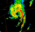
Cyclonic vortex over Pennsylvania with a trailing squall line
See also
 In Spanish: Clima extremo para niños
- List of severe weather phenomena
- Storm chasing