
Supercell facts for kids

A supercell is a very powerful and dangerous type of thunderstorm. These storms are known for being the biggest and most intense thunderstorms. What makes them special is a huge, spinning column of air called a mesocyclone. This spinning air, called an updraft, is what makes supercells so strong.
Many of the most powerful tornadoes (like EF3 to EF5 on the Enhanced Fujita Scale) grow from supercells. Besides tornadoes, supercells often bring very heavy rain, lots of lightning, strong winds, and large hail.
Contents
What Makes a Supercell Special?
Supercells usually form by themselves, away from other storms. Sometimes, they can be part of a bigger line of storms called a squall line. They often appear in the warm, moist air ahead of a cold front. Because they can last for many hours, they are sometimes called "quasi-steady-state" storms.
Supercells can move in unexpected ways. They might turn right or left compared to how the main winds are blowing. When this happens, they are called "right-movers" or "left-movers." Sometimes, one supercell can even split into two, with each part spinning in opposite directions!
Supercells come in different sizes, but they all produce a lot of hail, heavy rain, strong winds, and powerful downbursts (strong downward blasts of air). Supercells are one of the few types of storms that can create tornadoes inside their spinning mesocyclone. However, only about 30% of supercells actually produce a tornado.
Where Do Supercells Happen?
Supercells can form anywhere in the world if the weather conditions are just right. The first storm identified as a supercell was in Wokingham, England, studied in 1962.
Supercells happen most often in certain parts of the world. These areas include:
- The Great Plains of the central United States and southern Canada.
- Parts of the southeastern U.S. and northern Mexico.
- East-central Argentina and nearby areas of Uruguay.
- Bangladesh and parts of eastern India.
- South Africa.
- Eastern Australia.
They also happen sometimes in other places around the middle of the Earth, like Eastern China and across Europe. The places where supercells are most common are also where most tornadoes occur, like Tornado Alley in the U.S.
How Does a Supercell Form and Spin?

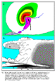
Imagine air spinning horizontally, like a log rolling on its side. This horizontal spin is caused by different wind speeds at different heights, which is called wind shear. When a strong updraft (rising air) lifts this spinning air, it makes the horizontal spin turn vertical. This creates the deep, spinning column of air called the mesocyclone.

Wind shear (red) makes air spin (green)
|

The updraft (blue) bends the spinning air upwards
|

Often, a "cap" or capping inversion is needed for a supercell to become very strong. This cap is like a lid that traps warm, moist air near the ground. This trapped air gets warmer and more unstable. When the cap finally breaks, the warm air bursts upwards very quickly, leading to an explosive storm development.
In North America, supercells often show up on Doppler radar with a "hook" shape. This hook is caused by rain and hail being wrapped around the spinning updraft.
Parts of a Supercell Storm

Overshooting Top
This is a dome-shaped bulge on top of the storm's anvil. It shows where the updraft is so strong that it punches through the top of the troposphere (the lowest layer of the atmosphere) into the stratosphere. From a satellite, it looks like a bubble on the smooth cloud top.
Anvil Cloud
The anvil is the flat, wide top of the storm that spreads out like an anvil. It forms when the storm's updraft hits the very top of the troposphere and can't go any higher. The air then spreads out horizontally. Anvils are very cold and don't have much rain. They can stretch far ahead of the storm.
Precipitation-Free Base
This area is usually on the side of the storm where air is flowing in. It looks like there's no rain falling, but sometimes large hail can be falling here. This is where the main updraft is located.
Wall Cloud
A wall cloud is a lowered, rotating cloud base that forms below the main updraft. It looks like it's dropping down from the storm. Wall clouds form when cool, moist air from the storm's downdraft gets pulled into the strong updraft. Not all wall clouds produce tornadoes, but if a storm does make a tornado, it usually has a wall cloud that lasts for more than ten minutes. If a wall cloud is moving violently up or down, or if cloud pieces around it are swirling, it's a sign that a tornado might form soon.
Mammatus Clouds
Mammatus clouds are cool, bubbly, or pillow-like clouds that hang down from the underside of the storm's anvil. They look most impressive when the sun is low in the sky, lighting them up from the side or below. Mammatus clouds can be seen with many strong thunderstorms, not just supercells.
Forward Flank Downdraft (FFD)

This is usually where the heaviest rain and hail fall. It's the "front" part of the storm where cool, rain-filled air is rushing downwards and spreading out.
Rear Flank Downdraft (RFD)
The Rear Flank Downdraft is a complex part of the supercell. It's believed to be very important for forming tornadoes. This is a surge of cooler, drier air that wraps around the back of the storm's updraft. It can cause very strong winds and is often seen on radar as a "hook echo."
Flanking Line
A flanking line is a line of smaller cumulus or cumulonimbus clouds that form near the supercell. They are created by warm, rising air being pulled into the main storm's updraft. Sometimes, small tornadoes called landspouts can form along this line.
How Supercells Look on Radar

Radar helps meteorologists see what's happening inside a supercell.
- Hook echo: This hook-shaped pattern on radar shows where the spinning updraft (mesocyclone) is located. It often means a tornado is present or could form.
- Bounded weak echo region (BWER): This is an area on radar where there are very weak echoes (meaning little rain or hail) surrounded by strong echoes. It shows where a very powerful updraft is located, and it can mean a tornado is present.
- V Notch: A V-shaped notch on the front edge of the storm, pointing away from the main downdraft. This shows strong air movement around a powerful updraft.
- Hail spike: This is a weak echo area behind the main storm on radar, seen at higher elevations. It suggests that large hail is present.
Images for kids
-
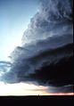
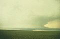
A low precipitation supercell shelf cloud. Shelf cloud forms when cooler air flows under warmer, moist air.
-
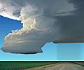
A supercell thunderstorm over Pikes Peak as seen from Palmer Park.
-
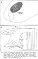
Schematics of an LP supercell.
-
Idealized view of an LP supercell.
-
Schematics of an HP supercell.
-
High precipitation supercell.
-
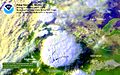
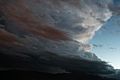
Satellite view of a supercell.


See also
 In Spanish: Supercelda para niños
