Tornado Alley facts for kids
Tornado Alley is a name for a large area in the central United States and Canada. It's where tornadoes happen most often. The name was first used in 1952 for a study project. This project looked at severe weather in parts of Texas, Louisiana, Oklahoma, Kansas, South Dakota, Iowa, and Nebraska. People who study tornadoes and storm chasers know this area as the main "tornado belt."
The exact borders of Tornado Alley are not set in stone. It's more of a common term. But most people agree it stretches from Texas, through Oklahoma, Kansas, Nebraska, South Dakota, Iowa, Minnesota, Wisconsin, Illinois, Indiana, Missouri, Arkansas, North Dakota, Montana, Ohio, and parts of Colorado and Wyoming. Some studies suggest that the main area might be moving eastward. Tornadoes are also becoming more common in the northern and eastern parts, reaching into the Canadian Prairies, Ohio, Michigan, and Southern Ontario.
Contents
Where is Tornado Alley?
Over the years, the exact location of Tornado Alley has not been clearly defined. The National Weather Service (NWS) has never officially set its boundaries. So, different ideas about its location come from different ways of looking at the data.
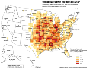
The National Severe Storms Laboratory (NSSL) says "Tornado Alley" is a term the news media uses. It refers to places that have a lot of tornadoes. One study from 1921 to 1995 found that almost a quarter of all strong tornadoes happened in this area.
States like Illinois, Wisconsin, Minnesota, Indiana, Michigan, and western Ohio are sometimes included. Some research shows that tornadoes are happening more often in the northern parts of Tornado Alley. This includes areas where it reaches the Canadian Prairies.
Tornadoes can happen almost anywhere on Earth. However, they are much more common in the United States. Especially in the central states, between the Rocky Mountains in the west and the Appalachian Mountains in the east. Texas has the highest total number of tornadoes of any state. Kansas and Oklahoma used to rank highest for tornadoes per area. But in 2013, Florida was reported to have the most tornadoes per area. Florida is not usually considered part of Tornado Alley. Florida's high number is partly because it gets many waterspouts. These are small tornadoes that form over water. While strong land tornadoes have hit Florida, they usually don't reach the same power as those in the Southern Plains. In the U.S., tornadoes often happen in late spring and early summer. This is when warm air meets cold air, creating storms.
Another way to define Tornado Alley is by where the strongest tornadoes happen most often. It can also be seen as an area from central Texas up to the Canadian Prairies. And from eastern Colorado to western Ohio.
Some experts believe there are several "Tornado Alleys." Besides the main Texas/Oklahoma/Kansas area, other places include the Upper Midwest, the lower Ohio Valley, the Tennessee Valley, and the lower Mississippi Valley. These areas might have their own special features. But a common idea is that there is one big Tornado Alley in the U.S. and Canada. This big area can then be divided into smaller parts based on regional features.
The southeastern U.S., especially the lower Mississippi Valley and the upper Tennessee Valley, is sometimes called "Dixie Alley." This name was made up in 1971. A study in 2018 found that from 1979 to 2017, tornadoes in the U.S. have been shifting eastward. This means more tornadoes are happening in Dixie Alley. The study showed fewer tornadoes in parts of the traditional Tornado Alley. And more tornadoes in places like eastern Arkansas and northern Mississippi.
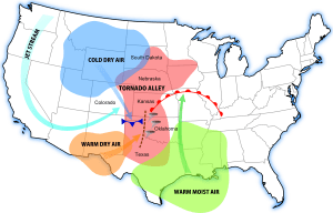
In Tornado Alley, warm, humid air from near the equator meets cool, dry air from Canada and the Rocky Mountains. This mix creates perfect conditions for tornadoes to form inside strong thunderstorms called supercells.
How the Term "Tornado Alley" Started
The term "tornado alley" was first used in 1952. It was created by U.S. Air Force weather experts Major Ernest J. Fawbush and Captain Robert C. Miller. They used it as the name for their research project. This project studied severe weather in parts of Texas and Oklahoma.
Staying Safe in Tornado Alley
Even though many strong tornadoes happen in Tornado Alley, building rules are not always stricter there. They are often weaker than in places that get many hurricanes, like south Florida. One town, Moore, Oklahoma, which has been hit by many tornadoes, did make its building rules stronger in 2014. Other common safety steps include building storm cellars. These are underground shelters. People also install tornado sirens to warn everyone. People in these areas are also very aware of tornadoes. They know how to prepare, and the news often covers weather.
The southeastern United States is known for very strong, long-lasting tornadoes. Many homes in this area are not as strong as in other parts of the U.S. Also, many people live in mobile homes. Because of this, more people get hurt or killed by tornadoes in the southern United States. Strong tornadoes happen less often here than in the traditional Tornado Alley. But when they do, they can be very severe and affect large areas.
How Often Do Tornadoes Happen?
These numbers are from the National Climatic Data Center. They show the 17 U.S. states with the highest average number of tornadoes (EF0-EF5) per 10,000 square miles each year. This data is for the period between 1991 and 2010.
- Florida: 12.3
- Kansas: 11.7
- Maryland: 9.9
- Illinois: 9.7
- Mississippi: 9.2
- Iowa: 9.1
- Oklahoma: 9
- South Carolina: 9
- Alabama: 8.6
- Louisiana: 8.5
- Arkansas: 7.5
- Nebraska: 7.4
- Missouri: 6.5
- North Carolina: 6.4
- Tennessee: 6.2
- Indiana: 6.1
- Texas: 5.9
Tornadoes in Canada
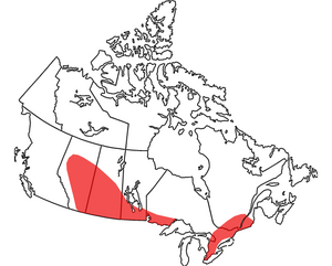
Canada has the second-highest number of tornadoes in the world, after the United States. The average number of tornadoes per equal land area is highest in the southern parts of Alberta, Saskatchewan, Manitoba, and Ontario.
About half of all Canadian tornadoes hit the Canadian Prairies and Northern Ontario up to Lake Superior. These regions form the northern edge of the U.S. Tornado Alley. Very strong tornadoes, up to F5 strength, have been recorded here.
Another third of Canadian tornadoes hit Southern Ontario and Quebec. This is especially true in the area between the Great Lakes and Canada's capital city, Ottawa. Tornadoes don't often hit areas behind lakes, but it can happen. Some, like the 2011 Goderich tornado, have been very strong. However, most Ontario tornadoes are in a narrow path from Windsor to Ottawa. They also happen in parts of Central Quebec. Tornadoes up to F4 strength have been recorded in this region.
In recent years, it seems the Ottawa Valley is getting more frequent and stronger tornadoes. The 2018 National Capital Region Outbreak caused two very strong tornadoes (EF3 and EF2). They caused a lot of damage in Ottawa and Gatineau. In 2023, five tornadoes hit the region. This new trend has led some people to call this area "Tornado Valley."
Weather in Southwestern Ontario is greatly affected by being a peninsula between the Great Lakes. Because of this, warmer temperatures in this area will likely cause more rain in storms. This is due to water evaporating from the lakes. Bigger temperature differences might also make tornadoes stronger and more frequent.
Northern Ontario, between the Manitoba border and Lake Superior, also gets severe tornadoes. But experts believe many tornadoes in this area are not reported. This is because very few people live there.
See also
 In Spanish: Tornado Alley para niños
- Hailstorm Alley
- Hurricane Alley
- List of tornadoes by calendar day
- Lists of tornadoes and tornado outbreaks
- Tornado climatology
 | Isaac Myers |
 | D. Hamilton Jackson |
 | A. Philip Randolph |


