Central United States facts for kids
The Central United States is a large area located in the middle of the United States. It's often thought of as the land between the Eastern United States and the Western United States. This region usually includes states from the Midwestern United States and parts of the Southern United States.
Because the United States is so big, people often divide it into different regions to make it easier to talk about. However, there isn't one official way to define the "Central United States." Different groups might include slightly different states depending on what they are studying.
Contents
Understanding the Central United States
The idea of the "Central United States" helps us understand the geography and culture of this large area. It includes many states that share similar landscapes, like wide plains and major rivers.
Which States are Often Included?
When people talk about the Central United States, they usually mean states like:
- Illinois
- Indiana
- Iowa
- Kansas
- Michigan (parts of it)
- Minnesota
- Missouri
- Nebraska
- North Dakota
- Ohio (parts of it)
- South Dakota
- Wisconsin
It also often includes central and western parts of the Southern states, such as:
- Alabama
- Arkansas
- Kentucky (western parts)
- Louisiana
- Mississippi
- Oklahoma
- Tennessee (western parts)
- Texas
Time Zones in the Central US
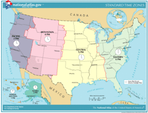
Most of the Central United States falls within the Central Time Zone. This means that clocks in these states are set to the same time. For example, if it's 10:00 AM in Chicago, Illinois, it's also 10:00 AM in Dallas, Texas.
However, some states in the Central US, like parts of Indiana and Ohio, are in the Eastern Time Zone. Also, the very western edges of states like North Dakota and South Dakota might be in the Mountain Time Zone. This is because time zones are set up to follow lines of longitude, which run north and south.
Images for kids
 | Stephanie Wilson |
 | Charles Bolden |
 | Ronald McNair |
 | Frederick D. Gregory |


