
Nebraska facts for kids
Quick facts for kids
Nebraska
|
|||
|---|---|---|---|
|
|||
| Nickname(s):
The Cornhusker State
|
|||
| Motto(s):
Equality before the law
|
|||
| Anthem: "Beautiful Nebraska" |
|||

Location of Nebraska within the United States
|
|||
| Country | United States | ||
| Before statehood | Nebraska Territory | ||
| Admitted to the Union | March 1, 1867 (37th) | ||
| Capital | Lincoln | ||
| Largest city | Omaha | ||
| Largest county or equivalent | Douglas | ||
| Largest metro and urban areas | Omaha–Council Bluffs | ||
| Legislature | Nebraska Legislature | ||
| Judiciary | Nebraska Supreme Court | ||
| U.S. senators | Deb Fischer (R) Pete Ricketts (R) |
||
| U.S. House delegation | 1: Mike Flood (R) 2: Don Bacon (R) 3: Adrian Smith (R) (list) |
||
| Area | |||
| • Total | 77,327 sq mi (200,356 km2) | ||
| • Land | 76,796 sq mi (199,099 km2) | ||
| • Water | 531 sq mi (1,247 km2) 0.7% | ||
| Area rank | 16th | ||
| Dimensions | |||
| • Length | 430 mi (690 km) | ||
| • Width | 210 mi (340 km) | ||
| Elevation | 2,600 ft (790 m) | ||
| Highest elevation
(Panorama Point)
|
5,424 ft (1,654 m) | ||
| Lowest elevation
(Missouri River at Kansas border)
|
840 ft (256 m) | ||
| Population
(2024)
|
|||
| • Total | 2,005,465 | ||
| • Rank | 37th | ||
| • Density | 24.94/sq mi (9.62/km2) | ||
| • Density rank | 43rd | ||
| • Median household income | $74,600 (2023) | ||
| • Income rank | 25th | ||
| Demonym(s) | Nebraskan | ||
| Language | |||
| • Official language | English | ||
| Time zones | |||
| most of state | UTC−06:00 (Central) | ||
| • Summer (DST) | UTC−05:00 (CDT) | ||
| Panhandle | UTC−07:00 (Mountain) | ||
| • Summer (DST) | UTC−06:00 (MDT) | ||
| USPS abbreviation |
NE
|
||
| ISO 3166 code | US-NE | ||
| Traditional abbreviation | Neb., Nebr. | ||
| Latitude | 40° N to 43° N | ||
| Longitude | 95° 19′ W to 104° 03′ W | ||


| Dance | Square dance |
|---|---|
| Bird | Western meadowlark |
| Fish | Channel catfish |
| Flower | Tall Goldenrod |
| Tree | Eastern Cottonwood |
| Insect | Western honey bee |
| River | Platte River |
Nebraska (nə-BRASS-kə) is a state in the Midwestern part of the United States. It is a landlocked state, meaning it has no coastlines. Nebraska shares borders with South Dakota to the north, Iowa and Missouri to the east (across the Missouri River), Kansas to the south, Colorado to the southwest, and Wyoming to the west.
Nebraska is the 16th largest state by land area, covering over 77,220 square miles (200,000 km²). With about 2 million people as of 2024, it is the 38th most populated state. This also makes it one of the least crowded states. The state capital is Lincoln, and its largest city is Omaha, located on the Missouri River.
Nebraska joined the United States in 1867, two years after the American Civil War ended. The Nebraska Legislature is special because it is unicameral. This means it has only one house or group of lawmakers, unlike most other states that have two. Also, its members are elected without showing their political party on the ballot. Nebraska is also one of only two states that divide their Electoral College votes by district. This means the winner doesn't take all the votes.
The state has two main land areas: the Dissected Till Plains and the Great Plains. The Dissected Till Plains are gently rolling hills in the east, where Omaha and Lincoln are. The Great Plains cover most of western Nebraska and are mostly treeless prairie. Eastern Nebraska has a humid continental climate (wet summers, cold winters), while western Nebraska is mostly semi-arid (drier). Temperatures change a lot between summer and winter. Thunderstorms and tornadoes are common in spring and summer.
Long ago, many Indigenous peoples lived here. These included the Omaha, Missouria, Ponca, Pawnee, Otoe, and Lakota (Sioux) tribes. Many famous trails, like the one used by the Lewis and Clark Expedition, cross the state. After the Transcontinental Railroad was built and the Homestead Acts were passed, many settlers moved to Nebraska in the 1870s and 1880s. This led to the state becoming known for its large farming industry.
Contents
What's in a Name?
Nebraska's name comes from words used by the Otoe and Omaha Native American tribes. The words Ñí Brásge (Otoe) or Ní Btháska (Omaha) mean "flat water." This name refers to the Platte River, which flows through the state.
Nebraska's Past: A Quick Look

Native American tribes lived in the Nebraska area for thousands of years. These included the Omaha, Missouria, Ponca, Pawnee, Otoe, and Lakota (Sioux) peoples.
When Europeans arrived, both Spain and France wanted to control this region.
- In the 1690s, Spain traded with the Apache people in western Nebraska.
- By 1703, France traded with Native peoples along the Missouri River.
- In 1720, Spain sent an army group led by Pedro de Villasur. This group was attacked and defeated by Pawnee and Otoe tribes, who were friends with the French. This stopped Spain's exploration of Nebraska for a long time.
In 1762, France gave the Louisiana territory to Spain. Later, in 1803, the United States bought this land from France in the Louisiana Purchase.
In 1819, the U.S. Army built Fort Atkinson. This was the first U.S. Army post west of the Missouri River. Many European-American settlers did not start moving here until after 1848, because of the California Gold Rush.
Becoming a Territory and a State
On May 30, 1854, the U.S. Congress created the Kansas Territory and the Nebraska Territory. The Nebraska Territory was much larger than the state is today. It included parts of what are now Colorado, North Dakota, South Dakota, Wyoming, and Montana. Omaha was the first capital of the Nebraska Territory.

In the 1860s, the U.S. government opened up large areas of land for farming. This happened after many Native American tribes moved to reservations. The Homestead Act offered free land to settlers. Thousands of people moved to Nebraska to claim this land. Since there were few trees on the prairies, many early settlers built their homes out of sod (grass and soil), just like some Native Americans did.
Nebraska became the 37th state on March 1, 1867. The capital moved from Omaha to Lancaster, which was renamed Lincoln to honor President Abraham Lincoln. The last big battle between the Pawnee and Sioux tribes, called the Massacre Canyon, happened in 1873.
Growth and New Ideas
From the 1870s to the 1880s, Nebraska's population grew a lot.
- The wide-open prairie was great for raising cattle.
- New farming tools like barbed wire, windmills, and the steel plow helped farmers.
- Good weather also made Nebraska excellent for farming.
By the 1880s, over 450,000 people lived in Nebraska. The holiday Arbor Day, which celebrates planting trees, was started in Nebraska City by Governor J. Sterling Morton.
Later, many African Americans moved to Omaha from the South. They came looking for jobs in meatpacking and railroads. Omaha has a long history of working for civil rights.
Since the 1960s, Native American groups in Nebraska have worked to improve their communities. They have built schools to keep their cultures alive and worked with state leaders on important issues.
Nebraska's Landscape

Nebraska has 93 counties. It is bordered by South Dakota, Iowa, Missouri, Kansas, Colorado, and Wyoming. The state is divided into two time zones: Central Time in the east and Mountain Time in the west.
Three main rivers flow through Nebraska from west to east:
- The Platte River (formed by the North Platte and South Platte) runs through the middle.
- The Niobrara River flows through the northern part.
- The Republican River crosses the southern part.
Nebraska has two main land regions:
- The Dissected Till Plains: These are gently rolling hills in the eastern part of the state, where Omaha and Lincoln are. This area was shaped by Ice Age glaciers.
- The Great Plains: This region covers most of western Nebraska. It includes areas like the Sandhills, the Pine Ridge, and the High Plains.
Panorama Point is Nebraska's highest spot, at 5,424 feet (1,653 m). Even though it's the highest, it's a gentle rise near the Colorado and Wyoming borders. A past tourism slogan for Nebraska was "Where the West Begins."
Nebraska's Weather

Nebraska has two main climate types. The eastern half has a humid continental climate, with warm, wet summers and cold winters. The western half has a semi-arid climate, which is drier. The whole state sees big changes in temperature and rainfall between seasons. Summers are hot, and winters are generally cold.
Rainfall decreases as you go from east to west. The southeast gets about 31.5 inches (800 mm) of rain each year, while the western Panhandle gets about 13.8 inches (350 mm). Snowfall is fairly even across the state, usually between 25 and 35 inches (65 and 90 cm) per year.
Nebraska is in Tornado Alley, a region where tornadoes are common. Thunderstorms and tornadoes happen mostly in spring and summer. Sometimes, warm chinook winds from the Rocky Mountains can make western Nebraska warmer in winter.
How Nebraska is Governed
Nebraska's government follows the Constitution of Nebraska, which was adopted in 1875. It has three main parts: the executive, legislative, and judicial branches.
Executive Branch: The Leaders
The main leader of the executive branch is the Governor. The Governor is like the chief executive of the state. Other elected officials in this branch include the Lieutenant Governor, Attorney General, Secretary of State, State Treasurer, and State Auditor. All these officials serve for four years.
Legislative Branch: Making Laws
Nebraska is the only state in the U.S. with a unicameral legislature. This means it has only one house for making laws. Even though it's called the "Legislature" or "Unicameral," its members are called "senators."
What's also unique is that Nebraska's Legislature is nonpartisan. This means that when people vote for senators, no political party is listed next to their names. Members from any party can be chosen to lead the Legislature or its committees. The Legislature can also overturn the governor's veto with a three-fifths vote. This is different from other states that often need a two-thirds vote.
Before 1934, Nebraska had two houses, like most states. But a U.S. Senator named George W. Norris thought having two houses was unnecessary. He argued that if everyone is equal, there's no need to do the same thing twice. He also pointed out that secret votes in committees could add things to bills that neither house had approved.
During the Great Depression, people in Nebraska voted to change their constitution. They decided to have a unicameral legislature, getting rid of the lower house. Today, Nebraska's unicameral legislature has rules that bills can only be about one topic and must be reviewed for at least five days.
The Legislature meets in the Nebraska State Capitol building in Lincoln. It was built between 1922 and 1932. The building has a tall, domed tower that is 400 feet (122 m) high. A 19-foot (5.8 m) bronze statue called "The Sower," which represents farming, sits on top of the building.
Judicial Branch: The Courts
Nebraska's court system is connected, with the Nebraska Supreme Court overseeing all other courts. Judges are chosen using the Missouri Plan. This plan helps select judges for all levels of courts, from the lowest county courts to the twelve district courts. The Court of Appeals handles appeals from these courts.
Who Lives in Nebraska?
| Historical population | |||
|---|---|---|---|
| Census | Pop. | %± | |
| 1860 | 28,841 | — | |
| 1870 | 122,993 | 326.5% | |
| 1880 | 452,402 | 267.8% | |
| 1890 | 1,062,656 | 134.9% | |
| 1900 | 1,066,300 | 0.3% | |
| 1910 | 1,192,214 | 11.8% | |
| 1920 | 1,296,372 | 8.7% | |
| 1930 | 1,377,963 | 6.3% | |
| 1940 | 1,315,834 | −4.5% | |
| 1950 | 1,325,510 | 0.7% | |
| 1960 | 1,411,330 | 6.5% | |
| 1970 | 1,483,493 | 5.1% | |
| 1980 | 1,569,825 | 5.8% | |
| 1990 | 1,578,385 | 0.5% | |
| 2000 | 1,711,263 | 8.4% | |
| 2010 | 1,826,341 | 6.7% | |
| 2020 | 1,961,504 | 7.4% | |
| 2023 (est.) | 1,978,379 | 8.3% | |
| Source: 1910–2020 | |||

In 2020, Nebraska's population was about 1,961,504 people. This was a 7.4% increase since 2010. The middle point of Nebraska's population is in Polk County, in the city of Shelby.
Most people in Nebraska are White (78.4%). Other groups include Black or African American (4.7%), Asian (2.5%), and American Indian and Alaska Native (1.0%). About 10.2% of the population is of Hispanic or Latino origin.
Many people in Nebraska have German (36.1%), Irish (13.1%), or English (7.8%) backgrounds. Nebraska also has the largest percentage of Czech American and non-Mormon Danish American people in the country. Thurston County has a majority of American Indian people.
In recent years, Nebraska has welcomed many refugees. In 2016, it took in more refugees per person than any other state. Lincoln, Nebraska, is a major home for Yazidis refugees in the United States.
Nebraska's Economy


Nebraska's economy is strong. In 2010, the state's total economic output was $89.8 billion. The average income per person in 2004 was $31,339, ranking 25th in the nation.
Farming is a huge part of Nebraska's economy. It is a top producer of beef, pork, wheat, corn, soybeans, and sorghum. Other important parts of the economy include:
- Freight transport (by train and truck)
- Manufacturing
- Telecommunications
- Information technology
- Insurance
In October 2021, Nebraska had a very low unemployment rate of 1.9%. This was the lowest ever recorded for any state!
Cool Inventions and Companies
- Kool-Aid was created in 1927 by Edwin Perkins in Hastings. Kool-Aid is the official soft drink of Nebraska!
- CliffsNotes, which are study guides for books, were developed by Clifton Hillegass from Rising City.
- Omaha is home to Berkshire Hathaway, a huge company led by Warren Buffett, one of the richest people in the world.
- Many other big companies are based in Omaha, like Mutual of Omaha (insurance) and Union Pacific Railroad (trains).
- In Lincoln, you'll find companies like Ameritas Life Insurance Corp. and Nelnet.
- Sidney is the main office for Cabela's, a store that sells outdoor goods.
- The world's largest train yard, Union Pacific's Bailey Yard, is in North Platte.
- The Vise-Grip was invented in Nebraska in 1924.
- Kawasaki Motors Manufacturing in Lincoln is the only Kawasaki plant in the world that makes Jet Skis, all-terrain vehicles (ATVs), and MULEs.
Energy in Nebraska
Nebraska is the second-largest producer of ethanol biofuels in the U.S. It doesn't have many fossil fuels, except for some crude oil. The state has a lot of renewable energy sources, especially from its farming industry.
Nebraska is the only state where all electric utilities are owned by the public. Half of its electricity comes from coal, and wind power has been growing fast.
Getting Around Nebraska
Trains
The Union Pacific Railroad, based in Omaha, was started in 1862. Its Bailey Yard in North Platte is the largest train yard in the world. The route of the first transcontinental railroad goes through Nebraska. Other major train companies like Amtrak and BNSF Railway also operate in the state.
Roads and Highways
Nebraska has several Interstate Highways and U.S. Routes that help people travel across the state.
- Interstate Highways:


- U.S. Routes:


Public Transportation
Cities like Lincoln and Omaha have public bus services. There are also intercity bus services like Burlington Trailways and Jefferson Lines that connect different cities.
Learning in Nebraska
Nebraska has many colleges and universities.
- University of Nebraska System: This includes the main campus in Lincoln, plus campuses in Kearney and Omaha. There's also a Medical Center and a College of Technical Agriculture.
- Nebraska State College System: This includes Chadron State College, Peru State College, and Wayne State College.
- Community Colleges: These offer two-year programs and job training. Examples include Central Community College and Metropolitan Community College.
- Private Colleges/Universities: Many private schools offer different types of degrees, such as Creighton University and Nebraska Wesleyan University.
Nebraska's Culture and Fun
Arts and Entertainment
Nebraska has many places to enjoy art and performances.
- Museums: You can find many museums across the state.
- Performing Arts:
- The Lied Center for Performing Arts in Lincoln hosts many shows.
- In Omaha, you can visit the Orpheum Theatre, Holland Performing Arts Center, and Omaha Community Playhouse.
- The Omaha Symphony performs concerts.
Sports in Nebraska

Nebraska loves sports!
Professional Teams
- Omaha Supernovas: A professional Volleyball team.
- Union Omaha: A professional soccer team.
- Omaha Storm Chasers: A minor league baseball team.
- Lincoln Saltdogs: An independent baseball team.
- Omaha Beef: An indoor football team.
College Sports
College sports are very popular, especially football! Nebraska has many schools that are part of the NCAA and other athletic associations.
The College World Series, which is the championship for college baseball, has been held in Omaha since 1950. It's now played at Charles Schwab Field Omaha.
Images for kids
-
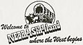
The Official Symbol and Slogan of Nebraska
-
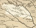
Nebraska in 1718, Guillaume de L'Isle map, with the approximate area of the future state highlighted.
-
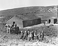
Homesteaders in central Nebraska in 1888.
-
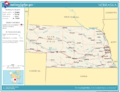
Map of Nebraska.
-
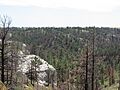
Forested hills in the Pine Ridge region of Nebraska.
-
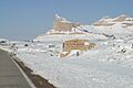
Winter at Scotts Bluff National Monument.
-
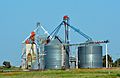
Nebraska grain bins and elevator
-
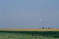
A cropduster in agrarian Nebraska, far west of Omaha
-
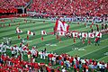
Football game at the University of Nebraska on September 6, 2008


See also
 In Spanish: Nebraska para niños
