U.S. Route 75 facts for kids
Quick facts for kids
U.S. Route 75 |
|
|---|---|
 |
|
| Route information | |
| Length | 1,239 mi (1,994 km) |
| Existed | 1926–present |
| Major junctions | |
| South end | |
|
|
| North end | Canada–US border at Noyes, MN; Port of Entry closed |
| Location | |
| States: | Texas, Oklahoma, Kansas, Nebraska, Iowa, Minnesota |
| Highway system | |
| United States Numbered Highways List • Bannered • Divided • Replaced |
|
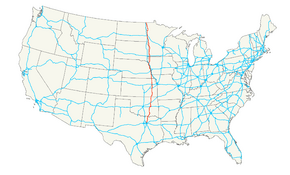
U.S. Route 75 is a long road in the central United States. It runs from north to south. This important road is part of the U.S. Highway system. It stretches for about 1,239 miles (1,994 km).
The road starts in the north at Noyes, Minnesota. This is right at the border with Canada. In the south, U.S. Route 75 ends in Dallas, Texas. Here, it meets Interstate 30 and Interstate 45. In Dallas, this part of the road is also known as the North Central Expressway.
Contents
Journey Through the States
U.S. Route 75 travels through six different states. It starts in Texas and goes north. Then it crosses into Oklahoma, Kansas, Nebraska, and Iowa. Finally, it reaches its northern end in Minnesota.
Texas: The Southern Start
In Texas, U.S. Route 75 begins in the big city of Dallas. It is a busy road there. Long ago, this highway used to go all the way to Galveston on the Gulf of Mexico. But now, that part of the road is called Texas State Highway 75. This change happened because a newer, faster road, Interstate 45, was built.
Oklahoma: Crossing the Plains
After Texas, U.S. Route 75 enters Oklahoma. It passes through cities like Tulsa. In Oklahoma, the road connects with other major highways. For example, it meets Interstate 40 and Interstate 44.
Kansas: Farmland and Cities
Next, the highway goes through Kansas. Here, you can see lots of farmland. It also goes through Topeka, the state capital. In Topeka, U.S. 75 connects with Interstate 70. This is another important cross-country road.
Nebraska and Iowa: River Views
As U.S. Route 75 continues north, it enters Nebraska. It passes through Omaha, a large city on the Missouri River. Then, it crosses into Iowa near Sioux City. The road often runs close to the Missouri River in these states.
Minnesota: The Northern End
Finally, U.S. Route 75 reaches Minnesota. It travels through the western part of the state. It passes by cities like Luverne and Moorhead. The journey ends in a small town called Noyes. This is where the road meets the border with Canada. The border crossing at Noyes is now closed.
Images for kids
-
U.S. Route 75/I-480 sign in Omaha
 | George Robert Carruthers |
 | Patricia Bath |
 | Jan Ernst Matzeliger |
 | Alexander Miles |


