
Scotts Bluff National Monument facts for kids
Quick facts for kids Scotts Bluff National Monument |
|
|---|---|
|
IUCN Category III (Natural Monument)
|
|

Covered Wagon on the Oregon Trail at Scotts Bluff
|
|

Scotts Bluff National Monument
Location in Nebraska

Scotts Bluff National Monument
Location in the United States
|
|
| Location | Scotts Bluff County, Nebraska, U.S. |
| Nearest city | Gering, Nebraska |
| Area | 3,005 acres (12.16 km2) |
| Created | December 12, 1919 |
| Visitors | 166,007 (in 2019) |
| Governing body | National Park Service |
| Website | Scotts Bluff National Monument |
Scotts Bluff National Monument is a special place in western Nebraska, United States. It protects over 3,000 acres of land. This land includes old trails, grassy plains, rocky badlands, tall bluffs, and areas along the North Platte River. Many people visit this monument each year to explore its history and nature.
The main bluff is named after Hiram Scott, a fur trader who died nearby in 1828. Scotts Bluff was a very important landmark for pioneers traveling west. It guided people on the Oregon Trail, California Trail, and Pony Express Trail. Over 250,000 pioneers saw Scotts Bluff between 1843 and 1869. It was one of the most mentioned landmarks in their travel journals.
The area around the bluff, including Scotts Bluff County and the city of Scottsbluff, Nebraska, got its name from this famous landmark.
Contents
Exploring Scotts Bluff's Geography
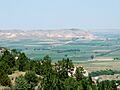
Even though it's called "Scotts Bluff National Monument," the area has two main bluffs. These are "South Bluff" and the northern "Scotts Bluff." There are five large rock formations on these bluffs. They are called Dome Rock, Crown Rock, Sentinel Rock, Eagle Rock, and Saddle Rock. The land between Scotts Bluff and the North Platte River is known as the "Badlands." This area has rough, eroded hills and valleys.
A Look Back at Scotts Bluff's History
Early Explorers and Fur Traders
The bluffs were first mapped in 1812 by fur traders on an expedition. They noticed these bluffs were the first big rock formations along the North Platte River. This marked where the Great Plains started to change into the foothills of the Rocky Mountains. Later, in 1823, explorers rediscovered this route. Fur traders then used the bluffs as a key landmark. European Americans named the main bluff after Hiram Scott. Local Native Americans called it Me-a-pa-te, meaning "the hill that is hard to go around."
A Guide for Westward Travelers

In the 1830s, fur traders, missionaries, and soldiers regularly passed Scotts Bluff. Starting in 1841, many settlers traveled past it on their way to Oregon, California, and Utah. All these groups used the bluff as a major guide.
At first, the Oregon Trail went south of Scotts Bluff. The Mormon Trail went north, across the North Platte River. In the early 1850s, a road was built through a natural gap between the bluffs. This gap became known as Mitchell Pass. After 1851, Mitchell Pass became the main route for the Oregon and California Trails. Pioneers liked this route better than going through the rough badlands or taking a longer southern detour. The use of these trails slowed down after 1869. This was because the transcontinental railroad was completed, making travel faster and easier.
Becoming a National Monument

On December 12, 1919, Scotts Bluff and nearby bluffs became a National Monument. The National Park Service was put in charge of protecting and managing this special place.
The Oregon Trail Museum and Visitor Center was built at the base of the bluff. It's a great place to start hiking tours. The museum teaches visitors about the pioneers and their journey west. It also shows drawings by William Henry Jackson and explains the area's geology and paleontology.
In the 1930s, a road was built to the top of Scotts Bluff. Workers from the Civilian Conservation Corps built this road. It goes through three tunnels and makes it easy to reach the summit. All historic sites managed by the National Park Service were added to the National Register of Historic Places in 1966.
The Name: Scotts Bluff
How Scotts Bluff Got Its Name
The bluff is named after Hiram Scott, a fur trader. He died near the bluff in 1828. His companions found his remains later, many miles from where he was last seen. The wild bluffs near his lonely grave have been called Scotts Bluff ever since.
The Correct Spelling
For a long time, people spelled the name "Scott's Bluff" or "Scotts Bluff." In 1941, the United States Board on Geographical Names made a final decision. They officially adopted the spelling Scotts Bluff (without an apostrophe). The nearby city is spelled Scottsbluff, as one word.

The Rocks of Scotts Bluff (Geology)


The bluffs are made of different layers of rock that formed over millions of years. The oldest rocks you can see are siltstones and mudstones. Above these are layers of siltstones that came from ancient volcanoes. Other layers include river sediments and wind-blown sands. The very top layers are hard, lime-cemented rocks. These hard layers protect the softer rocks below, giving the bluffs their tall, steep shapes.
Trails to Explore at the Monument

There are several trails for visitors to enjoy at Scotts Bluff National Monument:
- North Overlook Trail: This paved trail is about 0.5 miles long. It starts from the summit parking lot. From here, you can see great views of the North Platte River Valley. You can also reach the highest point on the bluff, which is 4,659 feet above sea level.
- South Overlook Trail: This paved trail is about 0.4 miles long. It also starts from the summit parking lot. From this overlook, you can see the Visitor Center and Mitchell Pass.
- Saddle Rock Trail: This trail starts at the Visitor Center and climbs 435 feet over 1.6 miles. The first part is fairly flat, leading to Scott's Spring. After that, it climbs steeply to the summit parking lot.
- Oregon Trail Pathway: This short trail climbs 85 feet in 0.5 miles. It begins near the display of old wagons and ends in Mitchell Pass.
- Bike Path: This is the only trail where bikes are allowed. It runs from the Visitor Center to the eastern edge of the park. It drops 50 feet over 1.2 miles.
Scotts Bluff's Legacy
Scotts Bluff County and the city of Scottsbluff were named after this important landmark.
During World War II, many oil tanker ships were built and named after national monuments. One of these ships, the SS Scotts Bluff, was built in 1944. It served in the war before its name was changed when it was sold in 1948.
Images for kids
-
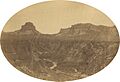
View through Mitchell Pass, July 1858. By Samuel C. Mills, photographer with the Simpson Expedition
-
View from the summit
-
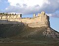
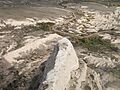
Saddle Rock in Scotts Bluff National Monument
-
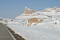
Scotts Bluff during winter (Nov. 2002)
-
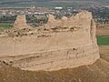
Looking north-northwest at Scottsbluff National Monument, Gering, Nebraska
-
Looking down at road and irrigation ditch to the northeast from Scotts Bluff National Monument


See also
 In Spanish: Monumento nacional de Scotts Bluff para niños
