Scotts Bluff County, Nebraska facts for kids
Quick facts for kids
Scotts Bluff County
|
|
|---|---|

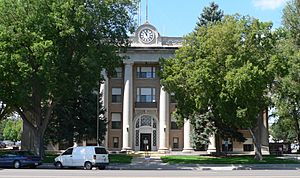
Scotts Bluff County Courthouse in Gering
|
|

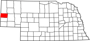
Location within the U.S. state of Nebraska
|
|
 Nebraska's location within the U.S. |
|
| Country | |
| State | |
| Founded | 1888 |
| Named for | Scotts Bluff |
| Seat | Gering |
| Largest city | Scottsbluff |
| Area | |
| • Total | 745 sq mi (1,930 km2) |
| • Land | 739 sq mi (1,910 km2) |
| • Water | 6.0 sq mi (16 km2) 0.8%% |
| Population
(2020)
|
|
| • Total | 36,084 |
| • Density | 49.2/sq mi (19.0/km2) |
| Time zone | UTC−7 (Mountain) |
| • Summer (DST) | UTC−6 (MDT) |
| Congressional district | 3rd |
Scotts Bluff County is a county located in the western part of Nebraska, a state in the United States. It sits right on the border with the state of Wyoming. In 2020, about 36,084 people lived here.
The main town where the county government is located, called the county seat, is Gering. The biggest city in the county is Scottsbluff. These two cities are close together and form an important urban area in Nebraska.
Scotts Bluff County is part of the Scottsbluff, NE Micropolitan Statistical Area. This means it's a smaller urban area that includes Scottsbluff and nearby communities.
If you look at Nebraska license plates, cars from Scotts Bluff County have the number 21. This is because when the state started its license plate system in 1922, Scotts Bluff County had the twenty-first highest number of registered vehicles.
Contents
History
Scotts Bluff County gets its name from a very famous natural landmark called Scotts Bluff. This tall bluff was a super important guide for pioneers traveling west in the 1800s on the Oregon Trail. Imagine trying to find your way across a huge country without GPS! Landmarks like Scotts Bluff were essential.
The bluff was named after a fur trapper named Hiram Scott. He was part of the Rocky Mountain Fur Company and sadly died near the bluff around 1828. A writer named Washington Irving wrote that Scott was injured and left behind by his group. He supposedly crawled for sixty miles but still didn't make it, dying near the bluff that now carries his name. Today, Scotts Bluff National Monument is a protected area managed by the National Park Service.
The town of Gering was started in 1887 right at the base of Scotts Bluff. A bit later, in 1900, the city of Scottsbluff was founded across the North Platte River. The river used to be a major travel route. Now, Gering and Scottsbluff are connected and together they form the 7th largest urban area in Nebraska.
Transportation
Scotts Bluff County has an airport called Scotts Bluff County Airport (BFF). It's the third busiest airport in Nebraska when you count how many passengers fly from there.
Geography
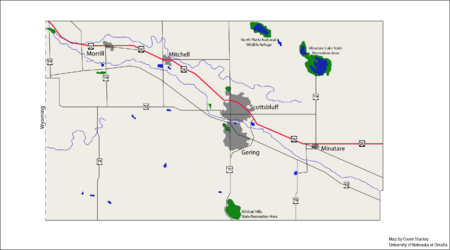
Scotts Bluff County is located on the far western side of Nebraska. Its western edge touches the eastern border of Wyoming. The North Platte River flows through the upper middle part of the county, heading towards the east-southeast.
The land in the county has rolling hills and is quite dry. About half of the land is used for farming. The land generally slopes downwards towards the east-southeast.
The county covers a total area of about 745 square miles (1,930 square kilometers). Out of this, 739 square miles (1,910 square kilometers) is land, and about 6.0 square miles (16 square kilometers) is water.
Major highways
Adjacent counties
- Sioux County – north
- Box Butte County – northeast
- Morrill County – east
- Banner County – south
- Goshen County, Wyoming – west
Protected areas
- Kiowa State Wildlife Management Area
- Lake Minatare State Recreation Area
- North Platte National Wildlife Refuge
- Scotts Bluff National Monument
- Wildcat Hills State Recreation Area
Population Information
| Historical population | |||
|---|---|---|---|
| Census | Pop. | %± | |
| 1890 | 1,888 | — | |
| 1900 | 2,552 | 35.2% | |
| 1910 | 8,355 | 227.4% | |
| 1920 | 20,710 | 147.9% | |
| 1930 | 28,644 | 38.3% | |
| 1940 | 33,917 | 18.4% | |
| 1950 | 33,939 | 0.1% | |
| 1960 | 33,809 | −0.4% | |
| 1970 | 36,432 | 7.8% | |
| 1980 | 38,344 | 5.2% | |
| 1990 | 36,025 | −6.0% | |
| 2000 | 36,951 | 2.6% | |
| 2010 | 36,970 | 0.1% | |
| 2020 | 36,084 | −2.4% | |
| 2022 (est.) | 35,603 | −3.7% | |
| US Decennial Census 1790-1960 1900-1990 1990-2000 2010-2013 2020-2022 |
|||
In 2000, there were about 36,951 people living in Scotts Bluff County. The population density was about 50 people per square mile. Many different groups of people live in the county, making it a diverse place.
Economy
The economy of Scotts Bluff County is mostly based on agriculture. This means that farming is a very important part of how people make a living there. The main crops grown in the area are sugar beets, corn, and beans.
Communities
Cities
- Gering (county seat)
- Minatare
- Mitchell
- Terrytown
- Scottsbluff
Villages
Unincorporated communities
See also
 In Spanish: Condado de Scotts Bluff para niños
 | Shirley Ann Jackson |
 | Garett Morgan |
 | J. Ernest Wilkins Jr. |
 | Elijah McCoy |


