Morrill, Nebraska facts for kids
Quick facts for kids
Morrill, Nebraska
|
|
|---|---|
|
Village
|
|

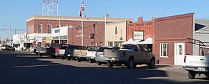
Downtown Morrill, February 2012
|
|

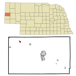
Location of Morrill, Nebraska
|
|
| Country | United States |
| State | Nebraska |
| County | Scotts Bluff |
| Area | |
| • Total | 0.61 sq mi (1.58 km2) |
| • Land | 0.61 sq mi (1.58 km2) |
| • Water | 0.00 sq mi (0.00 km2) |
| Elevation | 3,990 ft (1,220 m) |
| Population
(2020)
|
|
| • Total | 934 |
| • Density | 1,536.18/sq mi (592.90/km2) |
| Time zone | UTC-7 (Mountain (MST)) |
| • Summer (DST) | UTC-6 (MDT) |
| ZIP code |
69358
|
| Area code(s) | 308 |
| FIPS code | 31-32830 |
| GNIS feature ID | 2399397 |
Morrill is a small community called a village in Scotts Bluff County, Nebraska. It is located in the western part of Nebraska, known as the Panhandle. Morrill is part of the larger Scottsbluff, Nebraska area. In 2020, about 934 people lived there.
Contents
History of Morrill
How Morrill Started
In 1886, some settlers from Fort Collins, Colorado found a rich valley near a place called Sheep Creek. They decided to build a community there and named it Collins.
Moving the Town
In the early 1900s, a railroad was planned to come through the area. Because of this, a new town site was created about a mile from Collins. Charles Henry Morrill, who was in charge of the Lincoln Land Company, planned this new town. It was named after him and officially became a village in 1907.
Geography of Morrill
Morrill is a small village covering about 0.60 square miles (1.58 square kilometers). All of this area is land.
Population and People
| Historical population | |||
|---|---|---|---|
| Census | Pop. | %± | |
| 1910 | 346 | — | |
| 1920 | 772 | 123.1% | |
| 1930 | 756 | −2.1% | |
| 1940 | 877 | 16.0% | |
| 1950 | 849 | −3.2% | |
| 1960 | 884 | 4.1% | |
| 1970 | 937 | 6.0% | |
| 1980 | 1,097 | 17.1% | |
| 1990 | 974 | −11.2% | |
| 2000 | 957 | −1.7% | |
| 2010 | 921 | −3.8% | |
| 2020 | 934 | 1.4% | |
| U.S. Decennial Census | |||
Morrill's Population in 2010
According to the census from 2010, 921 people lived in Morrill. There were 417 households, which are groups of people living together. The village had about 1535 people per square mile.
Most of the people living in Morrill were White (93.3%). Some were Native American (1.3%) or Asian (0.5%). About 10.1% of the population identified as Hispanic or Latino.
The average age of people in Morrill was 44.1 years old. About 21% of residents were under 18. Also, 21.8% were 65 years old or older. Slightly more than half of the residents (52.1%) were female.
Roads and Transportation
Main Highways in Morrill
 U.S. Highway 26 is a major road that goes through Morrill from east to west.
- Nebraska Route 79-D, also known as So. Morrill Road, is another important route.
See also
 In Spanish: Morrill (Nebraska) para niños
 | Jessica Watkins |
 | Robert Henry Lawrence Jr. |
 | Mae Jemison |
 | Sian Proctor |
 | Guion Bluford |

