Morrill County, Nebraska facts for kids
Quick facts for kids
Morrill County
|
|
|---|---|

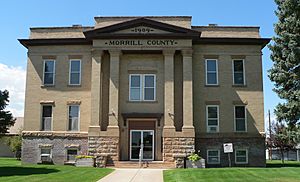
Morrill County Courthouse in Bridgeport
|
|

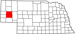
Location within the U.S. state of Nebraska
|
|
 Nebraska's location within the U.S. |
|
| Country | |
| State | |
| Founded | 1908 |
| Named for | Charles Henry Morrill |
| Seat | Bridgeport |
| Largest city | Bridgeport |
| Area | |
| • Total | 1,430 sq mi (3,700 km2) |
| • Land | 1,424 sq mi (3,690 km2) |
| • Water | 6.0 sq mi (16 km2) 0.4%% |
| Population
(2020)
|
|
| • Total | 4,555 |
| • Density | 3.185/sq mi (1.230/km2) |
| Time zone | UTC−7 (Mountain) |
| • Summer (DST) | UTC−6 (MDT) |
| Congressional district | 3rd |
Morrill County is a county located in the western part of the U.S. state of Nebraska. In 2020, about 4,555 people lived there. The main town and county seat (where the county government is) is Bridgeport.
If you see a Nebraska license plate, cars from Morrill County have the number 64. This is because Morrill County had the 64th largest number of vehicles registered in the state when the license plate system started in 1922.
Contents
History of Morrill County
Some important historical events happened in the area that is now Morrill County. In 1865, two battles, the Battle of Mud Springs and the Battle of Rush Creek, took place here. These battles were between the US Army and Native American tribes like the Cheyenne, Lakota Sioux, and Arapaho.
Morrill County was officially created on November 3, 1908. Before that, it was part of Cheyenne County. Voters in Cheyenne County decided to split the county into two parts. The northern part became Morrill County.
In December 1908, the people of the new county voted for Bridgeport to be their county seat. They also chose their first county officials. The county was named after Charles Henry Morrill, who was a president of a company called the Lincoln Land Company.
Geography and Landmarks
Morrill County has gently rolling hills. A lot of the land is used for farming, and some farms use special watering systems called center pivot irrigation. The North Platte River flows through the southern part of the county, passing by Bridgeport.
The county covers about 1,430 square miles. Most of this (1,424 square miles) is land, and a small part (6.0 square miles) is water.
One of the most famous landmarks in Nebraska, Chimney Rock, is located in western Morrill County. This amazing rock formation is about 325 feet tall, with a pointy top (spire) that is 120 feet high. It's about 4 miles south of Bayard.
Chimney Rock was a very important landmark for pioneers traveling on the Oregon Trail long ago. Today, it's a symbol of Nebraska and even appears on the state's license plates and its special commemorative quarter.
Neighboring Counties
Morrill County shares borders with several other counties:
- Box Butte County – to the north
- Sheridan County – to the northeast
- Garden County – to the east
- Cheyenne County – to the south
- Banner County – to the southwest
- Scotts Bluff County – to the northwest
Major Roads in Morrill County
Several important highways run through Morrill County:
 US 385 - This road goes north and south through the county.
 US 26 – This road runs northwest to southeast, following the north side of the North Platte River.
 Nebraska Highway 92 – This highway goes southeast from the western border and meets US 26 near Broadwater.
 Nebraska Highway 88 – This road goes east from the southwest part of the county, then turns north to meet US 385 in Bridgeport.
Population Information
| Historical population | |||
|---|---|---|---|
| Census | Pop. | %± | |
| 1910 | 4,584 | — | |
| 1920 | 9,151 | 99.6% | |
| 1930 | 9,950 | 8.7% | |
| 1940 | 9,436 | −5.2% | |
| 1950 | 8,263 | −12.4% | |
| 1960 | 7,057 | −14.6% | |
| 1970 | 5,813 | −17.6% | |
| 1980 | 6,085 | 4.7% | |
| 1990 | 5,423 | −10.9% | |
| 2000 | 5,440 | 0.3% | |
| 2010 | 5,042 | −7.3% | |
| 2020 | 4,555 | −9.7% | |
| 2022 (est.) | 4,527 | −10.2% | |
| US Decennial Census 1790-1960 1900-1990 1990-2000 2010 2020 2022 |
|||
According to the 2000 United States Census, there were 5,440 people living in Morrill County. The county had about 4 people per square mile.
Most of the people in the county (about 93.68%) were White. About 10.09% of the population identified as Hispanic or Latino. Many residents have German (40.5%), English (9.2%), Irish (7.3%), or American (6.7%) backgrounds.
The average age of people in Morrill County was 40 years old. About 27.20% of the population was under 18 years old.
Towns and Villages
Morrill County has several communities:
Cities
Village
Small Communities (Unincorporated)
Past Communities
Some communities that once existed in Morrill County are:
- Alden
- Chimney Rock
- Finley
- Goodstreak
- Hickory
- Kelly
- Kuhn
- Riley
- Simla
Law Enforcement in Morrill County
| Morrill County Sheriff's Office | |
|---|---|

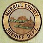
Patch of Morrill County Sheriff's Office
|
|
| Abbreviation | MCSO |
| Jurisdictional structure | |
| Operations jurisdiction | Morrill County, Nebraska, United States |
| Legal jurisdiction | Morrill County, Nebraska |
| Operational structure | |
| Headquarters | 6th & L St., Bridgeport, Nebraska 69336 |
| Agency executive |
|
The Morrill County Sheriff's Office is responsible for keeping the peace and enforcing laws in the county. In 2008, the office had four officers and five civilian staff members.
In 2009, Sheriff Johyn D. Edens received an award from the Humane Society of the United States. This award recognized his work in investigating a situation involving the care of 200 wild horses (mustangs) at an animal sanctuary.
In 2010, there was a very close election for the new Sheriff. Two candidates, Milo Cardenas and Travis Petersen, received the exact same number of votes. To decide who would go on to the final election, they had to draw cards! Milo Cardenas drew a nine of hearts, and Travis Petersen drew a six of spades, so Milo Cardenas won and became the Sheriff.
Images for kids
See also
 In Spanish: Condado de Morrill para niños
 | Janet Taylor Pickett |
 | Synthia Saint James |
 | Howardena Pindell |
 | Faith Ringgold |


