Angora, Nebraska facts for kids
Quick facts for kids
Angora, Nebraska
|
|
|---|---|

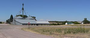
Angora, seen from the east across U.S. Highway 385
|
|
| Country | United States |
| State | Nebraska |
| County | Morrill |
| Elevation | 4,265 ft (1,300 m) |
| Time zone | UTC-7 (Mountain (MST)) |
| • Summer (DST) | UTC-6 (MDT) |
| ZIP code |
69331
|
| Area code(s) | 308 |
Angora (also called Antelope Hill) is a small, unincorporated community in the state of Nebraska, United States. An unincorporated community is a group of homes and buildings that does not have its own local government. Angora is located in northern Morrill County.
About Angora
Angora is found along U.S. Route 385, which is a main highway. It is north of Bridgeport, the largest town in Morrill County. The community sits high up, about 4,265 feet (1,300 meters) above sea level.
How Angora Got Its Name
The community of Angora was started in the year 1900. It was created by a railroad company called the Chicago, Burlington, and Quincy Railroad. They built a railway line through this area. Angora was named after a city in Turkey. At that time, the city in Turkey was known as Angora. Today, that same city is called Ankara.
Angora's Post Office
The Angora post office opened its doors in 1901. It has been serving the community ever since. The post office still operates today and has its own special ZIP code, which is 69331.
Weather in Angora
Angora has a type of weather called a semiarid climate. This means it is quite dry, but not as dry as a desert. It gets some rain, but not a lot. The summers are usually warm, and the winters are cold.
 | Aurelia Browder |
 | Nannie Helen Burroughs |
 | Michelle Alexander |


