Bridgeport, Nebraska facts for kids
Quick facts for kids
Bridgeport, Nebraska
|
|
|---|---|

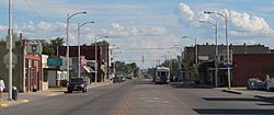
Main Street
|
|

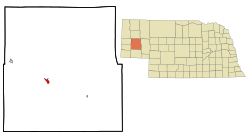
Location in Morrill County and the state of Nebraska
|
|
| Country | United States |
| State | Nebraska |
| County | Morrill |
| Area | |
| • Total | 1.20 sq mi (3.11 km2) |
| • Land | 1.20 sq mi (3.10 km2) |
| • Water | 0.00 sq mi (0.01 km2) |
| Elevation | 3,665 ft (1,117 m) |
| Population
(2020)
|
|
| • Total | 1,454 |
| • Density | 1,213.69/sq mi (468.43/km2) |
| Time zone | UTC-7 (Mountain (MST)) |
| • Summer (DST) | UTC-6 (MDT) |
| ZIP code |
69336
|
| Area code(s) | 308 |
| FIPS code | 31-06295 |
| GNIS feature ID | 2393416 |
Bridgeport is a city in Morrill County, Nebraska, United States. It is the main town, or county seat, of Morrill County. In 2020, about 1,454 people lived there.
Contents
History of Bridgeport
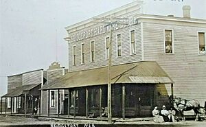
Bridgeport got its start in 1899. This was when the Chicago, Burlington and Quincy Railroad built its tracks through the area. The town was named after a bridge that crosses the North Platte River. Bridgeport officially became a village in 1901.
Geography and Location
Bridgeport is located in Morrill County. It is mostly on the south side of the North Platte River. Two major roads, U.S. Routes 26 and 385, meet in the city. They share a bridge over the North Platte River.
US 26 goes northwest about 38 miles to Scottsbluff. It goes southeast about 88 miles to Ogallala. US 385 goes north about 37 miles to Alliance. It goes south about 41 miles to Sidney. Nebraska Highway 92 also passes through Bridgeport. It offers a shorter route of 34 miles to Scottsbluff.
The city of Bridgeport covers a total area of about 1.20 square miles. A very small part of this, about 0.003 square miles, is water. This water area includes the part of the city that extends over the North Platte River.
Population and People
| Historical population | |||
|---|---|---|---|
| Census | Pop. | %± | |
| 1910 | 541 | — | |
| 1920 | 1,235 | 128.3% | |
| 1930 | 1,421 | 15.1% | |
| 1940 | 1,520 | 7.0% | |
| 1950 | 1,631 | 7.3% | |
| 1960 | 1,645 | 0.9% | |
| 1970 | 1,490 | −9.4% | |
| 1980 | 1,668 | 11.9% | |
| 1990 | 1,581 | −5.2% | |
| 2000 | 1,594 | 0.8% | |
| 2010 | 1,545 | −3.1% | |
| 2020 | 1,454 | −5.9% | |
| U.S. Decennial Census | |||
2010 Census Information
In 2010, Bridgeport had 1,545 people living there. There were 644 households, which are groups of people living together. The city had about 1,343 people per square mile.
Most of the people in Bridgeport were White (87.1%). About 19.2% of the population identified as Hispanic or Latino. The average age in the city was 40.3 years old. About 25.7% of the residents were under 18 years old.
Schools in Bridgeport
The Bridgeport Public Schools district has two main schools. There is one elementary school for younger students. There is also one junior/senior high school for older students. Both schools are located within Bridgeport.
Climate and Weather
Bridgeport experiences a variety of weather conditions. The data below shows the typical temperatures and rainfall. The lowest temperature ever recorded in Nebraska was in Bridgeport. It was -47 degrees Fahrenheit on February 12, 1899. This record was later matched by another city, Oshkosh, in 1989.
| Climate data for Bridgeport, Nebraska (1991–2020 normals, extremes 1897–present) | |||||||||||||
|---|---|---|---|---|---|---|---|---|---|---|---|---|---|
| Month | Jan | Feb | Mar | Apr | May | Jun | Jul | Aug | Sep | Oct | Nov | Dec | Year |
| Record high °F (°C) | 75 (24) |
80 (27) |
88 (31) |
95 (35) |
99 (37) |
107 (42) |
111 (44) |
109 (43) |
103 (39) |
97 (36) |
81 (27) |
74 (23) |
111 (44) |
| Mean maximum °F (°C) | 60.4 (15.8) |
65.1 (18.4) |
75.5 (24.2) |
83.4 (28.6) |
91.4 (33.0) |
98.7 (37.1) |
102.5 (39.2) |
99.6 (37.6) |
95.3 (35.2) |
83.7 (28.7) |
71.4 (21.9) |
60.6 (15.9) |
103.4 (39.7) |
| Mean daily maximum °F (°C) | 41.1 (5.1) |
45.0 (7.2) |
56.0 (13.3) |
64.2 (17.9) |
73.3 (22.9) |
85.2 (29.6) |
91.5 (33.1) |
89.1 (31.7) |
80.6 (27.0) |
65.6 (18.7) |
51.9 (11.1) |
41.1 (5.1) |
65.4 (18.6) |
| Daily mean °F (°C) | 28.4 (−2.0) |
31.6 (−0.2) |
41.0 (5.0) |
48.7 (9.3) |
58.5 (14.7) |
69.4 (20.8) |
75.8 (24.3) |
73.3 (22.9) |
64.3 (17.9) |
50.0 (10.0) |
37.8 (3.2) |
28.4 (−2.0) |
50.6 (10.3) |
| Mean daily minimum °F (°C) | 15.8 (−9.0) |
18.3 (−7.6) |
26.0 (−3.3) |
33.3 (0.7) |
43.7 (6.5) |
53.6 (12.0) |
60.1 (15.6) |
57.6 (14.2) |
48.0 (8.9) |
34.4 (1.3) |
23.7 (−4.6) |
15.7 (−9.1) |
35.9 (2.2) |
| Mean minimum °F (°C) | −7.9 (−22.2) |
−3.6 (−19.8) |
7.2 (−13.8) |
18.3 (−7.6) |
29.5 (−1.4) |
42.2 (5.7) |
50.1 (10.1) |
47.0 (8.3) |
33.0 (0.6) |
17.1 (−8.3) |
2.8 (−16.2) |
−6.6 (−21.4) |
−14.7 (−25.9) |
| Record low °F (°C) | −35 (−37) |
−47 (−44) |
−27 (−33) |
−11 (−24) |
15 (−9) |
28 (−2) |
34 (1) |
30 (−1) |
14 (−10) |
−7 (−22) |
−19 (−28) |
−42 (−41) |
−47 (−44) |
| Average precipitation inches (mm) | 0.36 (9.1) |
0.50 (13) |
0.91 (23) |
2.17 (55) |
3.31 (84) |
2.89 (73) |
2.43 (62) |
2.06 (52) |
1.70 (43) |
1.28 (33) |
0.57 (14) |
0.45 (11) |
18.63 (473) |
| Average snowfall inches (cm) | 6.2 (16) |
8.0 (20) |
5.1 (13) |
4.3 (11) |
0.7 (1.8) |
0.0 (0.0) |
0.0 (0.0) |
0.0 (0.0) |
0.3 (0.76) |
1.5 (3.8) |
4.8 (12) |
7.8 (20) |
38.7 (98) |
| Average precipitation days (≥ 0.01 in) | 3.3 | 3.8 | 4.5 | 7.0 | 9.2 | 8.0 | 6.4 | 5.3 | 4.8 | 5.1 | 2.9 | 3.2 | 63.5 |
| Average snowy days (≥ 0.1 in) | 2.4 | 3.0 | 2.1 | 1.3 | 0.2 | 0.0 | 0.0 | 0.0 | 0.1 | 0.7 | 1.9 | 2.6 | 14.3 |
| Source: NOAA | |||||||||||||
See also
 In Spanish: Bridgeport (Nebraska) para niños
 | Bayard Rustin |
 | Jeannette Carter |
 | Jeremiah A. Brown |


