
Sidney, Nebraska facts for kids
Quick facts for kids
Sidney, Nebraska
|
|
|---|---|

Carnegie library
|
|

Location within Cheyenne County and Nebraska
|
|
| Country | United States |
| State | Nebraska |
| County | Cheyenne |
| Area | |
| • Total | 7.49 sq mi (19.39 km2) |
| • Land | 7.49 sq mi (19.38 km2) |
| • Water | 0.00 sq mi (0.00 km2) |
| Elevation | 4,085 ft (1,245 m) |
| Population
(2020)
|
|
| • Total | 6,410 |
| • Density | 856.38/sq mi (330.65/km2) |
| Time zone | UTC−7 (Mountain (MST)) |
| • Summer (DST) | UTC−6 (MDT) |
| ZIP codes |
69160, 69162
|
| Area code(s) | 308 |
| FIPS code | 31-45295 |
| GNIS feature ID | 2395883 |
| Website | cityofsidney.org |
Sidney is a city in Cheyenne County, Nebraska, United States. It is the main city, also known as the county seat, of Cheyenne County. The city is about 9 miles (14 km) north of the Colorado state line. In 2020, about 6,410 people lived there.
Contents
A Look Back at Sidney's History
Sidney was founded in 1867. It was named after Sidney Dillon, who was the president of the Union Pacific Railroad. The city grew around Fort Sidney, a military base. Soldiers at Fort Sidney protected the transcontinental railroad from possible attacks.
Sidney's Role in Transportation
Sidney became an important stop for travelers. It was the southern end of the Sidney Black Hills Stage Road. This road helped people and soldiers reach places like Fort Robinson and Deadwood, South Dakota. When the railroad reached Sidney, it became a hub. The city had a roundhouse for trains and repair shops. There was also a hotel for railroad passengers.
Old West Stories
Sidney is home to one of the Old West's famous Boot Hill cemeteries. Many people buried there were soldiers from the fort.
Recent Changes in Sidney
For many years, the main office for Cabela's, a large outdoor retailer, was in Sidney. In 2017, another company bought Cabela's. This led to many jobs moving away from Sidney.
Exploring Sidney's Geography
Sidney covers about 6.93 square miles (17.95 square kilometers) of land. It is located in the western part of the Midwestern region, known for growing wheat. West of Sidney, the land is mostly used for raising cattle.
Location and Travel
Sidney is located along Lodgepole Creek. It is also right next to Interstate 80, a major highway. The city is found where U.S. Route 385 meets I-80. This makes Sidney a key stop for travelers. It's about halfway between Cheyenne, Wyoming, and North Platte, Nebraska.
Because of its location, a new business area has grown near the highway. This area includes truck stops, stores, hotels, and restaurants. In recent years, wind farms have been built nearby. These farms help the city grow and bring new energy to the area.
Who Lives in Sidney?
| Historical population | |||
|---|---|---|---|
| Census | Pop. | %± | |
| 1880 | 1,069 | — | |
| 1900 | 1,001 | — | |
| 1910 | 1,185 | 18.4% | |
| 1920 | 2,852 | 140.7% | |
| 1930 | 3,306 | 15.9% | |
| 1940 | 3,388 | 2.5% | |
| 1950 | 4,912 | 45.0% | |
| 1960 | 8,004 | 62.9% | |
| 1970 | 6,403 | −20.0% | |
| 1980 | 6,010 | −6.1% | |
| 1990 | 5,959 | −0.8% | |
| 2000 | 6,282 | 5.4% | |
| 2010 | 6,757 | 7.6% | |
| 2020 | 6,410 | −5.1% | |
| U.S. Decennial Census 2012 Estimate |
|||
Population in 2020
In 2020, the 2020 United States census counted 6,410 people living in Sidney. Most residents, about 87.8%, were white. About 8% of the population was Hispanic or Latino. Other groups included Asian, black or African-American, and Native American people.
There were 3,062 households in Sidney. About 21.1% of these households had children under 18. The average household had 2.1 people. The average family had 3.0 people.
The median age in Sidney was 37.9 years. This means half the people were younger than 37.9, and half were older. About 23.6% of the population was under 18. About 18.8% were 65 or older.
Population in 2010
In 2010, there were 6,757 people living in Sidney. The city had 2,893 households. About 30.9% of these households had children under 18. The average household size was 2.30 people.
The median age in 2010 was 37.1 years. About 25.1% of residents were under 18. About 15.3% were 65 or older.
Sidney's Climate
Sidney has a semi-arid climate. This means it is generally dry. Winters are cold and dry. Summers are hot and a bit wetter. Most of the rain falls during the summer months. The city gets about 18.24 inches (463 mm) of rain each year.
| Climate data for Sidney 6 NNW, Nebraska (1991–2020 normals, extremes 1927–present) | |||||||||||||
|---|---|---|---|---|---|---|---|---|---|---|---|---|---|
| Month | Jan | Feb | Mar | Apr | May | Jun | Jul | Aug | Sep | Oct | Nov | Dec | Year |
| Record high °F (°C) | 74 (23) |
78 (26) |
85 (29) |
96 (36) |
97 (36) |
110 (43) |
109 (43) |
106 (41) |
110 (43) |
94 (34) |
81 (27) |
80 (27) |
110 (43) |
| Mean maximum °F (°C) | 61.4 (16.3) |
65.0 (18.3) |
74.9 (23.8) |
80.9 (27.2) |
88.2 (31.2) |
95.5 (35.3) |
100.1 (37.8) |
98.3 (36.8) |
93.8 (34.3) |
84.5 (29.2) |
72.7 (22.6) |
63.0 (17.2) |
101.6 (38.7) |
| Mean daily maximum °F (°C) | 40.8 (4.9) |
42.8 (6.0) |
52.6 (11.4) |
59.5 (15.3) |
69.0 (20.6) |
81.2 (27.3) |
88.4 (31.3) |
86.0 (30.0) |
78.0 (25.6) |
63.5 (17.5) |
50.8 (10.4) |
41.4 (5.2) |
62.8 (17.1) |
| Daily mean °F (°C) | 28.8 (−1.8) |
30.7 (−0.7) |
39.3 (4.1) |
46.3 (7.9) |
56.1 (13.4) |
67.2 (19.6) |
73.9 (23.3) |
71.6 (22.0) |
63.1 (17.3) |
49.3 (9.6) |
37.7 (3.2) |
29.3 (−1.5) |
49.4 (9.7) |
| Mean daily minimum °F (°C) | 16.8 (−8.4) |
18.6 (−7.4) |
26.1 (−3.3) |
33.0 (0.6) |
43.2 (6.2) |
53.1 (11.7) |
59.4 (15.2) |
57.2 (14.0) |
48.2 (9.0) |
35.2 (1.8) |
24.7 (−4.1) |
17.2 (−8.2) |
36.1 (2.3) |
| Mean minimum °F (°C) | −4.9 (−20.5) |
−2.5 (−19.2) |
6.4 (−14.2) |
16.1 (−8.8) |
26.8 (−2.9) |
40.3 (4.6) |
49.0 (9.4) |
46.4 (8.0) |
32.8 (0.4) |
15.9 (−8.9) |
4.4 (−15.3) |
−3.1 (−19.5) |
−11.3 (−24.1) |
| Record low °F (°C) | −33 (−36) |
−30 (−34) |
−27 (−33) |
−7 (−22) |
15 (−9) |
29 (−2) |
36 (2) |
35 (2) |
13 (−11) |
−2 (−19) |
−19 (−28) |
−39 (−39) |
−39 (−39) |
| Average precipitation inches (mm) | 0.30 (7.6) |
0.50 (13) |
0.95 (24) |
1.88 (48) |
3.00 (76) |
3.15 (80) |
2.60 (66) |
2.11 (54) |
1.65 (42) |
1.15 (29) |
0.51 (13) |
0.44 (11) |
18.24 (463) |
| Average snowfall inches (cm) | 3.8 (9.7) |
4.9 (12) |
4.3 (11) |
3.2 (8.1) |
0.7 (1.8) |
0.0 (0.0) |
0.0 (0.0) |
0.0 (0.0) |
0.1 (0.25) |
2.4 (6.1) |
3.7 (9.4) |
5.7 (14) |
28.8 (73) |
| Average precipitation days (≥ 0.01 in) | 2.4 | 3.5 | 4.4 | 5.9 | 8.6 | 8.4 | 7.3 | 5.9 | 5.0 | 4.5 | 2.6 | 2.2 | 60.7 |
| Average snowy days (≥ 0.1 in) | 2.0 | 2.4 | 1.7 | 1.0 | 0.2 | 0.0 | 0.0 | 0.0 | 0.0 | 0.8 | 1.5 | 1.9 | 11.5 |
| Source: NOAA | |||||||||||||
Things to See and Do
.jpg)
- Historic Fort Sidney is a place you can visit to learn about the past.
Getting Around Sidney
The Sidney Stage Line provides bus service in the city. It runs Monday through Saturday. There are 12 stops along its route.
Famous People From Sidney
- Rod Horn, a professional football player for the Cincinnati Bengals.
- Harry Northup, an actor and poet.
- Ken Ramos, a baseball player.
- Luke Short, a famous gunfighter from the Old West.
Images for kids
-
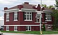
Carnegie library
-
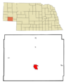
Location within Cheyenne County and Nebraska
-
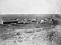
Sidney, 1868
See also
 In Spanish: Sidney (Nebraska) para niños
