Lodgepole Creek facts for kids
Quick facts for kids Lodgepole Creek |
|
|---|---|

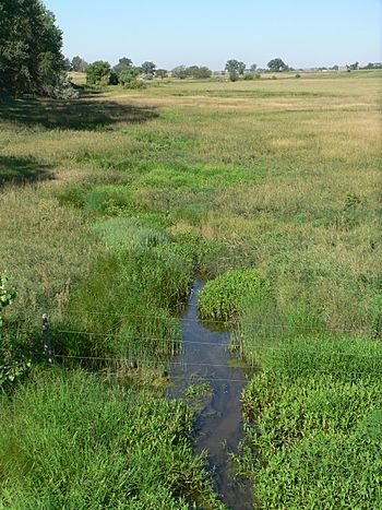
Lodgepole Creek north of Kimball, Nebraska
|
|
| Physical characteristics | |
| Main source | 41°19′17″N 105°11′57″W / 41.32139°N 105.19917°W |
| River mouth | Confluence with South Platte River 3,517 ft (1,072 m) 40°57′18″N 102°23′04″W / 40.95500°N 102.38444°W |
| Length | 278 mi (447 km) |
| Basin features | |
| Progression | South Platte—Platte—Missouri—Mississippi |
Lodgepole Creek is a stream about 278 mi (447 km) long. It flows through parts of Wyoming, Nebraska, and Colorado. This creek is a branch of the South Platte River. It helps drain a wide, flat area between the South Platte and North Platte rivers. This area is in southeastern Wyoming, southern Nebraska, and northeastern Colorado.
Even though it's called a "creek," it's quite small. For most of its journey, it flows through dry, flat grasslands called the High Plains. For over 100 years, the Lodgepole Creek Valley has been an important path for travel. Major routes like the original transcontinental railroad, the Lincoln Highway, U.S. Highway 30, and Interstate 80 all follow this creek for a long way.
Where Lodgepole Creek Flows
Lodgepole Creek starts in the Laramie Mountains in southeastern Wyoming. This is about 10 miles (16 km) east of Laramie, Wyoming. The creek flows east, passing north of Cheyenne, Wyoming. It then enters Nebraska just east of Pine Bluffs, Wyoming.
In Nebraska, the creek continues to flow east. It goes past towns like Kimball, Nebraska, Sidney, Nebraska, and Chappell, Nebraska. At Chappell, Lodgepole Creek turns to the southeast and flows into Colorado. The stream then flows south and empties into the South Platte River at Ovid, Colorado. This spot is about 3 miles (5 km) south of the Nebraska/Colorado border.
Early Use for Farming
People have used Lodgepole Creek for a long time. In 1871, the first irrigation (watering crops) in the Nebraska Panhandle happened in the Lodgepole Valley. A dam was built across the creek at Fort Sidney. This dam helped provide water for crops grown by the soldiers at the fort.
As more settlers moved into the valley, they built many more dams and ditches. These helped them direct water from the creek to their farms. Even with all these uses, the creek kept flowing downstream. This was because the valley was narrow, and springs along the creek's path kept adding water to it.
 | Roy Wilkins |
 | John Lewis |
 | Linda Carol Brown |

