Sheridan County, Nebraska facts for kids
Quick facts for kids
Sheridan County
|
|
|---|---|

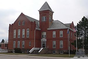
Sheridan County Courthouse in Rushville
|
|

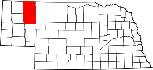
Location within the U.S. state of Nebraska
|
|
 Nebraska's location within the U.S. |
|
| Country | |
| State | |
| Founded | 1885 |
| Named for | Philip Sheridan |
| Seat | Rushville |
| Largest city | Gordon |
| Area | |
| • Total | 2,470 sq mi (6,400 km2) |
| • Land | 2,441 sq mi (6,320 km2) |
| • Water | 29 sq mi (80 km2) 1.2%% |
| Population
(2020)
|
|
| • Total | 5,127 |
| • Density | 2.076/sq mi (0.8014/km2) |
| Time zone | UTC−7 (Mountain) |
| • Summer (DST) | UTC−6 (MDT) |
| Congressional district | 3rd |
Sheridan County is a county located in the state of Nebraska in the United States. As of 2020, about 5,127 people live here. The main town, also known as the county seat, is Rushville.
Sheridan County was created in 1885. It was named after a famous general, Philip H. Sheridan. If you see a Nebraska license plate with the number 61, it means the car is from Sheridan County. This number was given because it had the sixty-first largest number of registered vehicles in Nebraska back in 1922.
Contents
Exploring Sheridan County's Land
Sheridan County is located in the northern part of Nebraska. Its northern border touches the state of South Dakota. The Niobrara River flows through the northern central part of the county. The land here has rolling hills and some small lakes, especially in the eastern and southern areas.
The county covers a total area of about 2,470 square miles (6,397 square kilometers). Most of this is land, with about 29 square miles (75 square kilometers) being water. Sheridan County is the fourth-largest county in Nebraska by size.
Main Roads in the County
These are the important highways that run through Sheridan County:
Neighboring Counties
Sheridan County shares its borders with several other counties:
- Oglala Lakota County, South Dakota - to the north
- Cherry County - to the east
- Grant County - to the southeast
- Garden County - to the south
- Morrill County - to the southwest
- Dawes County - to the west
- Box Butte County - also to the west
Special Natural Areas
Sheridan County is home to a couple of protected natural spots:
- Smith Lake State Wildlife Management Area
- Walgren Lake State Recreation Area
People of Sheridan County
| Historical population | |||
|---|---|---|---|
| Census | Pop. | %± | |
| 1890 | 8,687 | — | |
| 1900 | 3,066 | −64.7% | |
| 1910 | 7,328 | 139.0% | |
| 1920 | 9,625 | 31.3% | |
| 1930 | 10,793 | 12.1% | |
| 1940 | 9,869 | −8.6% | |
| 1950 | 9,539 | −3.3% | |
| 1960 | 9,049 | −5.1% | |
| 1970 | 7,285 | −19.5% | |
| 1980 | 7,544 | 3.6% | |
| 1990 | 6,750 | −10.5% | |
| 2000 | 6,198 | −8.2% | |
| 2010 | 5,469 | −11.8% | |
| 2020 | 5,127 | −6.3% | |
| 2022 (est.) | 4,996 | −8.6% | |
| US Decennial Census 1790-1960 1900-1990 1990-2000 2010 2020 2022 |
|||
In 2000, there were about 6,198 people living in Sheridan County. The population density was about 2 people per square mile. Most people in the county were White, and a smaller group were Native American.
About 30% of the households had children under 18 living with them. Many households were married couples. The average age of people in the county was 42 years old. About 25% of the population was under 18 years old.
Towns and Villages
Sheridan County has a few towns and villages where people live.
Cities
Villages
Special Places
- Whiteclay is a census-designated place. This means it's a community that is counted in the census but isn't officially a city or village.
Other Communities
These are smaller places that are not officially cities or villages:
Old Towns
- Antioch is a ghost town, meaning it was once a community but is now mostly abandoned.
See also
 In Spanish: Condado de Sheridan (Nebraska) para niños
 | James Van Der Zee |
 | Alma Thomas |
 | Ellis Wilson |
 | Margaret Taylor-Burroughs |

