Grant County, Nebraska facts for kids
Quick facts for kids
Grant County
|
|
|---|---|

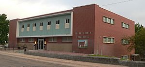
Grant County Courthouse in Hyannis
|
|

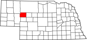
Location within the U.S. state of Nebraska
|
|
 Nebraska's location within the U.S. |
|
| Country | |
| State | |
| Founded | March 31, 1887 |
| Named for | Ulysses S. Grant |
| Seat | Hyannis |
| Largest village | Hyannis |
| Area | |
| • Total | 783 sq mi (2,030 km2) |
| • Land | 776 sq mi (2,010 km2) |
| • Water | 7.0 sq mi (18 km2) 0.9%% |
| Population
(2020)
|
|
| • Total | 611 |
| • Density | 0.7803/sq mi (0.3013/km2) |
| Time zone | UTC−7 (Mountain) |
| • Summer (DST) | UTC−6 (MDT) |
| Congressional district | 3rd |
Grant County is a county in the state of Nebraska, USA. In 2020, about 611 people lived there. This makes it one of the smallest counties in Nebraska. The main town, or county seat, is called Hyannis. Grant County was started in 1887. It was named after Ulysses S. Grant, who was the 18th President of the United States.
In Nebraska, cars have special license plates. Each county has a number on its plates. Grant County has the number 92. This number was given in 1922, based on how many vehicles were registered in the county at that time.
Contents
Geography of Grant County
Grant County has a unique landscape. It has many rolling hills that go from east to west. These hills make the area look like gentle waves. Because of this, you can find many small lakes and water areas scattered around the county.
The United States Census Bureau says that Grant County covers a total area of about 783 square miles. Most of this area, about 776 square miles, is land. The rest, about 7 square miles, is water.
Main Roads in Grant County
Neighboring Counties
- Cherry County (north)
- Hooker County (east)
- Arthur County (south)
- Garden County (west)
- Sheridan County (northwest)
People of Grant County
| Historical population | |||
|---|---|---|---|
| Census | Pop. | %± | |
| 1890 | 458 | — | |
| 1900 | 763 | 66.6% | |
| 1910 | 1,097 | 43.8% | |
| 1920 | 1,486 | 35.5% | |
| 1930 | 1,427 | −4.0% | |
| 1940 | 1,327 | −7.0% | |
| 1950 | 1,057 | −20.3% | |
| 1960 | 1,009 | −4.5% | |
| 1970 | 1,019 | 1.0% | |
| 1980 | 877 | −13.9% | |
| 1990 | 769 | −12.3% | |
| 2000 | 747 | −2.9% | |
| 2010 | 614 | −17.8% | |
| 2020 | 611 | −0.5% | |
| US Decennial Census 1790-1960 1900-1990 1990-2000 2010 |
|||
In 2000, there were 747 people living in Grant County. These people made up 292 households and 226 families. The county had about 0.95 people per square mile.
Most of the people in the county were White (about 98.80%). A small number were Native American (0.13%), Asian (0.27%), or from other backgrounds (0.80%). About 1.34% of the population was Hispanic or Latino.
About 37% of the households had children under 18 living with them. Most households (67.50%) were married couples living together. About 22.30% of all households were single people. About 8.90% of these were people aged 65 or older living alone. The average household had 2.56 people.
The age of people in the county varied. About 29.20% were under 18 years old. About 13.70% were 65 years or older. The average age was 40 years. For every 100 females, there were about 114 males.
The average income for a household in the county was $34,821. For families, the average income was $37,011. About 9.70% of the population lived below the poverty line. This included 16.70% of those under 18.
Towns and Villages
Village
- Hyannis (This is the county seat, which means it's the main town where the county government is located.)
Unincorporated Communities
These are smaller places that are not officially organized as towns or villages.
Ghost Town
- Duluth (A ghost town is a place that used to be a town but is now mostly empty.)
See also
 In Spanish: Condado de Grant (Nebraska) para niños
 | Sharif Bey |
 | Hale Woodruff |
 | Richmond Barthé |
 | Purvis Young |

