Oglala Lakota County, South Dakota facts for kids
Quick facts for kids
Oglala Lakota County
|
|
|---|---|

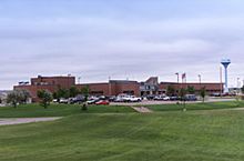
Indian Health Service Hospital in Pine Ridge on the Pine Ridge Indian Reservation, November 2011
|
|

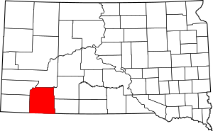
Location within the U.S. state of South Dakota
|
|
 South Dakota's location within the U.S. |
|
| Country | |
| State | |
| Founded | 1875 |
| Named for | Oglala Lakota people |
| Seat | None (de jure) Hot Springs (de facto) |
| Largest community | Pine Ridge |
| Area | |
| • Total | 2,097 sq mi (5,430 km2) |
| • Land | 2,094 sq mi (5,420 km2) |
| • Water | 2.8 sq mi (7 km2) 0.1% |
| Population
(2020)
|
|
| • Total | 13,672 |
| • Estimate
(2023)
|
13,434 |
| • Density | 6.5198/sq mi (2.5173/km2) |
| Time zone | UTC−7 (Mountain) |
| • Summer (DST) | UTC−6 (MDT) |
| Congressional district | At-large |
| Hot Springs in neighboring Fall River County serves as administrative center for county | |
Oglala Lakota County is a special area in southwestern South Dakota, United States. It was known as Shannon County until May 2015. In 2020, about 13,672 people lived here.
Even though it's a county, Oglala Lakota County doesn't have its own main office building or "county seat." Instead, the nearby town of Hot Springs helps manage its paperwork. The county was created in 1875. The biggest community in the county is Pine Ridge.
This county is entirely inside the Pine Ridge Indian Reservation. It also includes part of Badlands National Park. Oglala Lakota County is one of five counties in South Dakota that are completely on an Indian reservation.
The county gets its name from the Oglala Lakota people. They are a group within the larger Lakota people. Many people living in the county are members of this group. The local newspaper for the county is The Lakota Country Times.
Contents
History of Oglala Lakota County
Early Beginnings and Name Change
Oglala Lakota County was first created in 1875. It was part of the Dakota Territory back then. The county was originally named after Peter C. Shannon. He was a important judge in the Dakota Territory.
A very sad event, the Wounded Knee Massacre, happened here in 1890.
For many years, Oglala Lakota County was considered "unorganized." This meant it didn't have its own fully working local government. In 1982, it became more organized. However, it still gets help from Fall River County for some important tasks. These tasks include keeping records and managing money.
Renaming the County
On November 4, 2014, the people living in the county voted to change its name. They wanted to rename it from Shannon County to Oglala Lakota County. The vote passed by a large margin.
The state government of South Dakota officially approved this name change. This happened on March 5, 2015. The governor announced that May 1, 2015, would be the official day for the new name.
Geography of Oglala Lakota County
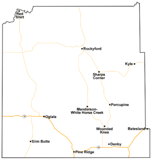
Oglala Lakota County is located in the southern part of South Dakota. Its southern border touches the state of Nebraska. The Cheyenne River flows along the northwest edge of the county. The White River also flows through the middle of the county.
The land here has rolling hills and some small mountains. It is a semi-dry area. The highest point in the county is about 3,619 feet (1,103 meters) above sea level. The county covers a total area of about 2,097 square miles (5,431 square kilometers). Most of this is land, with a small amount of water.
The Little White River also starts in this county.
Main Roads in the County
Neighboring Counties
- Pennington County - north
- Jackson County - northeast
- Bennett County - east
- Sheridan County, Nebraska - south
- Dawes County, Nebraska - southwest
- Fall River County - west
- Custer County - northwest
Protected Natural Areas
- Badlands National Park (part of it is in the county)
Lakes in the County
- Alkali Lake
- Denby Lake
- Lee Lake
- Oglala Lake
- Two Lance Lake
- Wakpamani Lake
- White Clay Lake
Population Information
| Historical population | |||
|---|---|---|---|
| Census | Pop. | %± | |
| 1920 | 2,003 | — | |
| 1930 | 4,058 | 102.6% | |
| 1940 | 5,366 | 32.2% | |
| 1950 | 5,669 | 5.6% | |
| 1960 | 6,000 | 5.8% | |
| 1970 | 8,198 | 36.6% | |
| 1980 | 11,323 | 38.1% | |
| 1990 | 9,902 | −12.5% | |
| 2000 | 12,466 | 25.9% | |
| 2010 | 13,586 | 9.0% | |
| 2020 | 13,672 | 0.6% | |
| 2023 (est.) | 13,434 | −1.1% | |
| U.S. Decennial Census 1790-1960 1900-1990 1990-2000 2010-2020 |
|||
Population in 2020
According to the 2020 census, there were 13,672 people living in Oglala Lakota County. There were 3,208 households, which are groups of people living together. The county had 3,454 housing units, which are places where people can live.
Communities in Oglala Lakota County
Town
Census-Designated Places (CDPs)
These are areas that are like towns but don't have their own local government.
Unincorporated Communities
These are smaller communities that are not officially towns or CDPs.
County Divisions
Oglala Lakota County does not have smaller divisions called townships. Instead, it is divided into two "unorganized territories." These are called East Oglala Lakota and West Oglala Lakota. They used to be known as East Shannon and West Shannon.
See also
 In Spanish: Condado de Shannon (Dakota del Sur) para niños
 | Mary Eliza Mahoney |
 | Susie King Taylor |
 | Ida Gray |
 | Eliza Ann Grier |


